Estimated Value: $489,616 - $552,000
3
Beds
2
Baths
1,432
Sq Ft
$370/Sq Ft
Est. Value
About This Home
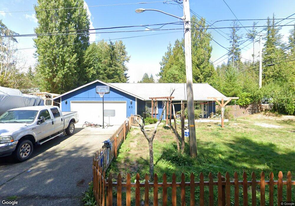
This home is located at 20 E Oakdale St, Allyn, WA 98524 and is currently estimated at $529,154, approximately $369 per square foot. 20 E Oakdale St is a home located in Mason County with nearby schools including Grapeview Elementary/Middle School.
Ownership History
Date
Name
Owned For
Owner Type
Purchase Details
Closed on
Nov 30, 2016
Sold by
Walter Devon A
Bought by
Walter Devon A and Walter Katie
Current Estimated Value
Home Financials for this Owner
Home Financials are based on the most recent Mortgage that was taken out on this home.
Original Mortgage
$187,151
Outstanding Balance
$152,277
Interest Rate
3.94%
Mortgage Type
VA
Estimated Equity
$376,877
Purchase Details
Closed on
May 11, 2010
Sold by
White Scott W and White Mary S
Bought by
Walter Devon A
Home Financials for this Owner
Home Financials are based on the most recent Mortgage that was taken out on this home.
Original Mortgage
$213,493
Interest Rate
5.04%
Mortgage Type
VA
Create a Home Valuation Report for This Property
The Home Valuation Report is an in-depth analysis detailing your home's value as well as a comparison with similar homes in the area
Home Values in the Area
Average Home Value in this Area
Purchase History
| Date | Buyer | Sale Price | Title Company |
|---|---|---|---|
| Walter Devon A | -- | First American Title | |
| Walter Devon A | $209,000 | Mason County Title Ins Co |
Source: Public Records
Mortgage History
| Date | Status | Borrower | Loan Amount |
|---|---|---|---|
| Open | Walter Devon A | $187,151 | |
| Closed | Walter Devon A | $213,493 |
Source: Public Records
Tax History Compared to Growth
Tax History
| Year | Tax Paid | Tax Assessment Tax Assessment Total Assessment is a certain percentage of the fair market value that is determined by local assessors to be the total taxable value of land and additions on the property. | Land | Improvement |
|---|---|---|---|---|
| 2025 | $3,270 | $441,620 | $79,050 | $362,570 |
| 2023 | $3,270 | $383,945 | $77,865 | $306,080 |
| 2022 | $3,117 | $355,550 | $45,615 | $309,935 |
| 2021 | $2,731 | $355,550 | $45,615 | $309,935 |
| 2020 | $2,398 | $309,875 | $35,090 | $274,785 |
| 2018 | $2,312 | $213,180 | $26,700 | $186,480 |
| 2017 | $1,988 | $213,240 | $26,760 | $186,480 |
| 2016 | $1,855 | $195,015 | $25,490 | $169,525 |
| 2015 | $1,823 | $181,590 | $31,980 | $149,610 |
| 2014 | -- | $171,535 | $28,600 | $142,935 |
| 2013 | -- | $159,910 | $24,700 | $135,210 |
Source: Public Records
Map
Nearby Homes
- 90 E Treasure Island Dr
- 5662 E State Route 302
- 460 E Stretch Island Rd S
- 7360 E Grapeview Loop Rd
- 70 E Sund Rd
- 17717 E State Route 3
- 400 E McLane Cove Dr
- 8320 E Grapeview Loop Rd
- 116th 166th St NW
- 80 E Channel Dr
- 9321 185th Avenue Ct NW
- 350 E Mountain View Dr
- 310 E Rauschert Rd
- 430 Twilight Way
- 40 E Lakeshore Dr
- 7504 Crescent Beach Rd NW
- 0 E Wheelwright St S
- 101 E Mountain View Dr
- 0 Sullivan Rd
- 31 E Village View Dr
- 40 E Oakdale St
- 0 43XX Grapeview Loop Rd
- 0 E2318 Grapeview Loop Rd
- 2 Grapeview Loop Rd
- 1 Grapeview Loop Rd
- 0 TR 4 Grapeview Loop Rd
- 0 XXXX Grapeview Loop Rd
- 0 TR 13 Grapeview Loop Rd
- 0 L3 Grapeview Loop Rd
- 0 L4 Grapeview Loop Rd
- 5540 Grapeview Loop Rd
- 0 OFF Grapeview Loop Rd
- 60 E Oakdale St
- 5641 E Grapeview Loop Rd
- 51 E Oakdale St
- 82 E Oakdale St
- 86 E Oakdale St
- 5661 E Grapeview Loop Rd
- 71 E Oakdale St
- 91 E Country Ln