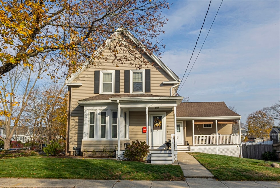
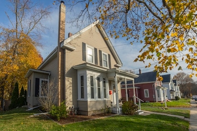
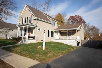
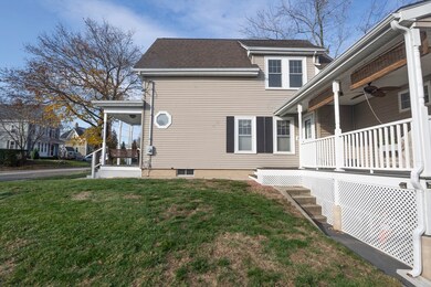
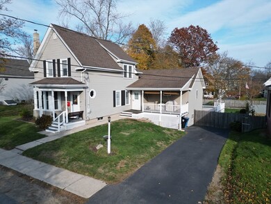
20 Elm Place Whitman, MA 02382
Estimated payment $3,721/month
Highlights
- Very Popular Property
- Colonial Architecture
- Wood Flooring
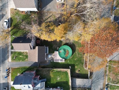
- Above Ground Pool
- Deck
- 5-minute walk to Whitman Town Park
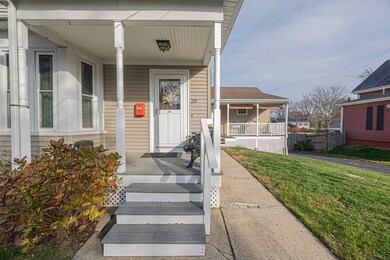
About This Home
OH Thurs 11/20 5-6pm & Sat 11/22 11-12:30. Attention first-time buyers! Nearly 2,000 sq. ft. and priced under $600K, this home sits on a quiet dead-end just a short walk to the commuter rail, downtown Whitman and local events. Offering 4 beds and 2.5 baths, the home features hardwood floors, a cozy family room with wood stove, and a large kitchen with ample cabinetry and dining area.A spacious addition provides a huge dining room with wet bar and French doors to the back deck—perfect for entertaining or use as a second family room. The lower level includes a game room with half bath ready for finishing and walk-out access to the fenced backyard with Jacuzzi and pool featuring an oversized deck for summer enjoyment. Additional perks include rear parking off English Place and a fenced garden area ideal for raised beds or vegetables. A great opportunity to own a well-maintained, spacious home close to everything Whitman offers!
Home Details
Home Type
- Single Family
Est. Annual Taxes
- $6,641
Year Built
- Built in 1890
Lot Details
- 0.32 Acre Lot
- Fenced
- Cleared Lot
- Property is zoned A2
Home Design
- Colonial Architecture
- Block Foundation
- Concrete Perimeter Foundation
Interior Spaces
- 1,970 Sq Ft Home
- Wet Bar
- Chair Railings
- Crown Molding
- Ceiling Fan
- Recessed Lighting
- French Doors
- Dining Area
- Game Room
Kitchen
- Oven
- Microwave
- Dishwasher
- Stainless Steel Appliances
- ENERGY STAR Cooktop
- Solid Surface Countertops
- Disposal
Flooring
- Wood
- Laminate
Bedrooms and Bathrooms
- 4 Bedrooms
- Primary Bedroom on Main
- Soaking Tub
- Bathtub with Shower
- Separate Shower
Basement
- Basement Fills Entire Space Under The House
- Laundry in Basement
Parking
- 2 Car Parking Spaces
- Off-Street Parking
Pool
- Above Ground Pool
- Spa
Outdoor Features
- Balcony
- Deck
- Patio
- Outdoor Storage
Utilities
- Window Unit Cooling System
- Forced Air Heating and Cooling System
- Heating System Uses Natural Gas
- Pellet Stove burns compressed wood to generate heat
- Heating System Uses Steam
- Gas Water Heater
Community Details
- No Home Owners Association
Listing and Financial Details
- Assessor Parcel Number M:0001 B:0021 L:30,1199427
Map
Home Values in the Area
Average Home Value in this Area
Tax History
| Year | Tax Paid | Tax Assessment Tax Assessment Total Assessment is a certain percentage of the fair market value that is determined by local assessors to be the total taxable value of land and additions on the property. | Land | Improvement |
|---|---|---|---|---|
| 2025 | $6,641 | $506,200 | $215,200 | $291,000 |
| 2024 | $6,189 | $485,800 | $211,000 | $274,800 |
| 2023 | $5,923 | $436,500 | $182,900 | $253,600 |
| 2022 | $5,859 | $402,400 | $166,300 | $236,100 |
| 2021 | $5,651 | $364,600 | $152,800 | $211,800 |
| 2020 | $5,437 | $343,000 | $138,200 | $204,800 |
| 2019 | $5,114 | $332,500 | $138,200 | $194,300 |
| 2018 | $4,398 | $290,300 | $124,100 | $166,200 |
| 2017 | $4,364 | $289,400 | $124,100 | $165,300 |
| 2016 | $4,233 | $271,500 | $118,200 | $153,300 |
| 2015 | $4,238 | $271,500 | $118,200 | $153,300 |
Property History
| Date | Event | Price | List to Sale | Price per Sq Ft |
|---|---|---|---|---|
| 11/24/2025 11/24/25 | Pending | -- | -- | -- |
| 11/17/2025 11/17/25 | For Sale | $599,900 | -- | $305 / Sq Ft |
Purchase History
| Date | Type | Sale Price | Title Company |
|---|---|---|---|
| Quit Claim Deed | -- | -- | |
| Deed | $31,700 | -- |
Mortgage History
| Date | Status | Loan Amount | Loan Type |
|---|---|---|---|
| Previous Owner | $20,000 | No Value Available | |
| Previous Owner | $90,000 | No Value Available | |
| Previous Owner | $86,000 | No Value Available | |
| Previous Owner | $55,000 | No Value Available |
Source: MLS Property Information Network (MLS PIN)
MLS Number: 73455735
APN: WHIT-000001-000021-000030
Disclaimer: Certain information contained herein is derived from information provided by parties other than Homes.com. All information provided is deemed reliable, but is not guaranteed to be accurate and should be independently verified.
![]() The property listing data and information, or the Images, set forth herein were provided to MLS Property Information Network, Inc. from third party sources, including sellers, lessors and public records, and were compiled by MLS Property Information Network, Inc. The property listing data and information, and the Images, are for the personal, non-commercial use of consumers having a good faith interest in purchasing or leasing listed properties of the type displayed to them and may not be used for any purpose other than to identify prospective properties which such consumers may have a good faith interest in purchasing or leasing. MLS Property Information Network, Inc. and its subscribers disclaim any and all representations and warranties as to the accuracy of the property listing data and information, or as to the accuracy of any of the Images, set forth herein.
The property listing data and information, or the Images, set forth herein were provided to MLS Property Information Network, Inc. from third party sources, including sellers, lessors and public records, and were compiled by MLS Property Information Network, Inc. The property listing data and information, and the Images, are for the personal, non-commercial use of consumers having a good faith interest in purchasing or leasing listed properties of the type displayed to them and may not be used for any purpose other than to identify prospective properties which such consumers may have a good faith interest in purchasing or leasing. MLS Property Information Network, Inc. and its subscribers disclaim any and all representations and warranties as to the accuracy of the property listing data and information, or as to the accuracy of any of the Images, set forth herein.
- 48 Day St
- 109 Fullerton Ave
- 54-56 Stetson St
- 383 Washington St
- 532 Washington St
- 53 Temple St
- 150 Harvard St
- 135-137 Temple St
- 159 Auburn St
- 154 Auburn St
- 164 Warren Ave
- 277 School St
- 551 Bedford St Unit B4
- 22 Old Coach Rd
- 84 Washington St
- 63 Dewey Ave
- 604 Bedford St Unit 5
- 23 Reed Place
- 40 Lazel St
- 24 Churchill Ave
