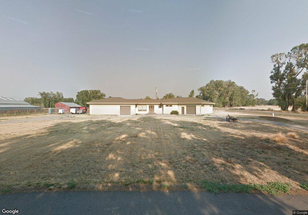
20 Emrie Ln Bozeman, MT 59718
Four Corners NeighborhoodEstimated Value: $260,000
About This Home
This home is located at 20 Emrie Ln, Bozeman, MT 59718 and is currently priced at $260,000, approximately $73 per square foot. 20 Emrie Ln is a home located in Gallatin County with nearby schools including Monforton Primary School, Monforton Elementary School, and Monforton Junior High School.
Ownership History
We collect this data history from publicly available records. To have your information removed, we recommend requesting removal directly through your county’s website.
Purchase Details
Purchase Details
Purchase Details
Home Values in the Area
Average Home Value in this Area
Purchase History
We collect this data history from publicly available records. To have your information removed, we recommend requesting removal directly through your county’s website.
| Date | Buyer | Sale Price | Title Company |
|---|---|---|---|
| -- | None Listed On Document | ||
| -- | -- | ||
| -- | Montana Title And Escrow |
Tax History
We collect this data history from publicly available records. To have your information removed, we recommend requesting removal directly through your county’s website.
| Year | Tax Paid | Tax Assessment Tax Assessment Total Assessment is a certain percentage of the fair market value that is determined by local assessors to be the total taxable value of land and additions on the property. | Land | Improvement |
|---|---|---|---|---|
| 2025 | $6,005 | $873,500 | $0 | $0 |
| 2024 | $5,008 | $671,500 | $0 | $0 |
| 2023 | $4,821 | $671,500 | $0 | $0 |
| 2022 | $4,474 | $466,400 | $0 | $0 |
| 2021 | $2,507 | $326,026 | $0 | $0 |
| 2020 | $2,252 | $289,447 | $0 | $0 |
| 2019 | $2,224 | $289,447 | $0 | $0 |
| 2018 | $2,045 | $241,209 | $0 | $0 |
| 2017 | $1,986 | $241,209 | $0 | $0 |
| 2016 | $1,942 | $232,417 | $0 | $0 |
| 2015 | $1,891 | $232,417 | $0 | $0 |
| 2014 | $1,896 | $140,106 | $0 | $0 |
Map
- 118 Dovetail Ln
- 1391 Cobb Hill Rd
- 31 Ladybug Ln
- TBD Dovetail Ln
- TBD Elk Ln
- 138 Albrey Trail Unit C
- Lot 1 Bridge District
- 50 Pattee Trail
- 104 Arrowhead Trail
- 402 Circle F Trail
- 95 Arrowhead Trail
- 254 Pattee Trail
- 108 Violet Rd
- 516 Circle F Trail
- 3 Mallard Ln
- 3490 Magenta Rd
- TBD Indigo
- 262 Parklands Trail
- 288 Parklands Trail
- 112 Hilgard Peak Ct
- 1021 Cobb Hill Rd
- 62 Emrie Ln
- Lot 1 Emrie Ln
- Lot 5A Emrie Ln
- 900 Cobb Hill Rd
- Lot 4 Emrie Ln
- 897 Cobb Hill Rd
- 1111 Cobb Hill Rd
- 858 Cobb Hill Rd
- Lot 3 Emrie Ln
- 1060 Cobb Hill Rd
- 1211 Cobb Hill Rd
- 135 Emrie Ln
- 1150 Cobb Hill Rd
- 807 Cobb Hill Rd
- 815 Cobb Hill Rd
- 1120 Beatty Rd
- 1226 Cobb Hill Rd
- 1169 Beatty Rd
- 1148 Beatty Rd
Ask me questions while you tour the home.