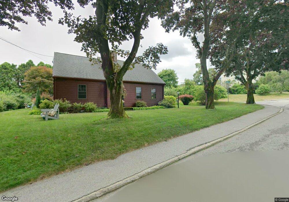
20 Gould Rd Plymouth, MA 02360
North Plymouth NeighborhoodEstimated Value: $451,000 - $633,000
3
Beds
1
Bath
1,170
Sq Ft
$456/Sq Ft
Est. Value
About This Home
This home is located at 20 Gould Rd, Plymouth, MA 02360 and is currently estimated at $533,292, approximately $455 per square foot. 20 Gould Rd is a home located in Plymouth County with nearby schools including Cold Spring, Plymouth Community Intermediate, and Plymouth North High School.
Ownership History
Date
Name
Owned For
Owner Type
Purchase Details
Closed on
Jun 15, 2012
Sold by
Lawrence Cynthia M and Lawrence Seth C
Bought by
Cynthia M Lawrence T M and Cynthia Lawrence
Current Estimated Value
Purchase Details
Closed on
Apr 24, 2006
Sold by
Lawrence Cynthia M
Bought by
Lawrence Cynthia M and Lawrence Seth C
Purchase Details
Closed on
Nov 4, 2005
Sold by
Pimental Richard M
Bought by
Lawrence Cynthia M
Create a Home Valuation Report for This Property
The Home Valuation Report is an in-depth analysis detailing your home's value as well as a comparison with similar homes in the area
Home Values in the Area
Average Home Value in this Area
Purchase History
| Date | Buyer | Sale Price | Title Company |
|---|---|---|---|
| Cynthia M Lawrence T M | -- | -- | |
| Lawrence Cynthia M | -- | -- | |
| Lawrence Cynthia M | $150,000 | -- |
Source: Public Records
Tax History Compared to Growth
Tax History
| Year | Tax Paid | Tax Assessment Tax Assessment Total Assessment is a certain percentage of the fair market value that is determined by local assessors to be the total taxable value of land and additions on the property. | Land | Improvement |
|---|---|---|---|---|
| 2025 | $5,598 | $441,100 | $241,700 | $199,400 |
| 2024 | $5,326 | $413,800 | $219,700 | $194,100 |
| 2023 | $5,291 | $385,900 | $206,000 | $179,900 |
| 2022 | $5,462 | $354,000 | $196,800 | $157,200 |
| 2021 | $5,373 | $332,500 | $196,800 | $135,700 |
| 2020 | $5,229 | $319,800 | $186,700 | $133,100 |
| 2019 | $4,851 | $293,300 | $160,200 | $133,100 |
| 2018 | $4,581 | $278,300 | $146,500 | $131,800 |
| 2017 | $4,379 | $264,100 | $146,500 | $117,600 |
| 2016 | $4,147 | $254,900 | $137,300 | $117,600 |
| 2015 | $3,961 | $254,900 | $137,300 | $117,600 |
| 2014 | $3,792 | $250,600 | $137,300 | $113,300 |
Source: Public Records
Map
Nearby Homes
- 211 Court St
- 52 Liberty St Unit L3
- 52 Liberty St Unit C5
- 291 Court St
- 60 Robbins Rd Unit 25
- 63 Cherry St
- 134 Court St Unit 6
- 134 Court St Unit 9
- 134 Court St Unit 12
- 216 Water St Unit B306
- 216 Water St Unit 101B
- 15 Caswell Ln Unit 6
- 4 S Spooner St Unit 6
- 4 S Spooner St Unit 7
- 4 S Spooner St Unit 8
- 2 S Spooner St Unit 3
- 2 S Spooner St Unit 1
- 2 S Spooner St Unit 4
- 20-22 Hedge Rd
- 100 Court St
- 18 Gould Rd
- 34 Hall St
- 117 Standish Ave
- 119 Standish Ave
- 115 Standish Ave
- 32 Hall St
- 21 Gould Rd
- 17 Gould Rd
- 14 Gould Rd
- 113 Standish Ave Unit 113
- 28 Hall St
- 15 Gould Rd
- 121 Standish Ave Unit B
- 121 Standish Ave Unit A
- 121 Standish Ave Unit B-2nd floor
- 121 Standish Ave Unit A-1st floor
- 121 Standish Ave Unit B-2nd Fl
- 121 Standish Ave Unit A -1st Fl
- 121 Standish Ave
- 31 Hall St