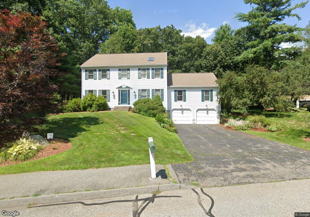
20 Jacobs Rd Marlborough, MA 01752
Estimated Value: $824,873 - $1,006,000
4
Beds
3
Baths
2,780
Sq Ft
$332/Sq Ft
Est. Value
About This Home
This home is located at 20 Jacobs Rd, Marlborough, MA 01752 and is currently estimated at $923,218, approximately $332 per square foot. 20 Jacobs Rd is a home located in Middlesex County with nearby schools including Marlborough High School, Hillside School, and First Steps Children's Center.
Ownership History
Date
Name
Owned For
Owner Type
Purchase Details
Closed on
Sep 30, 1998
Sold by
Smith Timothy J and Smith Anne P
Bought by
Damenti Nicholas and Damenti Barbara M
Current Estimated Value
Home Financials for this Owner
Home Financials are based on the most recent Mortgage that was taken out on this home.
Original Mortgage
$227,000
Interest Rate
6.89%
Mortgage Type
Purchase Money Mortgage
Purchase Details
Closed on
Dec 16, 1996
Sold by
Beutler Gregory S and Beutler Pamela D
Bought by
Smith Timothy J and Smith Anne P
Home Financials for this Owner
Home Financials are based on the most recent Mortgage that was taken out on this home.
Original Mortgage
$214,000
Interest Rate
7.75%
Mortgage Type
Purchase Money Mortgage
Create a Home Valuation Report for This Property
The Home Valuation Report is an in-depth analysis detailing your home's value as well as a comparison with similar homes in the area
Home Values in the Area
Average Home Value in this Area
Purchase History
| Date | Buyer | Sale Price | Title Company |
|---|---|---|---|
| Damenti Nicholas | $310,000 | -- | |
| Smith Timothy J | $267,500 | -- |
Source: Public Records
Mortgage History
| Date | Status | Borrower | Loan Amount |
|---|---|---|---|
| Closed | Smith Timothy J | $210,000 | |
| Closed | Smith Timothy J | $265,000 | |
| Closed | Smith Timothy J | $227,000 | |
| Previous Owner | Smith Timothy J | $214,000 |
Source: Public Records
Tax History Compared to Growth
Tax History
| Year | Tax Paid | Tax Assessment Tax Assessment Total Assessment is a certain percentage of the fair market value that is determined by local assessors to be the total taxable value of land and additions on the property. | Land | Improvement |
|---|---|---|---|---|
| 2025 | $7,689 | $779,800 | $239,600 | $540,200 |
| 2024 | $7,373 | $720,000 | $217,800 | $502,200 |
| 2023 | $7,612 | $659,600 | $188,600 | $471,000 |
| 2022 | $7,360 | $561,000 | $179,900 | $381,100 |
| 2021 | $0 | $534,200 | $150,300 | $383,900 |
| 2020 | $7,243 | $510,800 | $143,300 | $367,500 |
| 2019 | $6,924 | $492,100 | $140,700 | $351,400 |
| 2018 | $0 | $474,500 | $129,800 | $344,700 |
| 2017 | $6,957 | $454,100 | $132,000 | $322,100 |
| 2016 | $6,799 | $443,200 | $132,000 | $311,200 |
| 2015 | $6,830 | $433,400 | $135,600 | $297,800 |
Source: Public Records
Map
Nearby Homes
- 28 Evelina Dr
- 207 Bigelow St
- 28 Brook Ln
- 0 Dudley St
- 238 W Hill Rd
- 306 Berlin Rd
- 10 Masciarelli Dr
- 287 Elm St
- 113 Brigham St Unit 3B
- 113 Brigham St Unit 5C
- 18 Alden Dr Unit 3
- 0 Pleasant St
- 13 Wilshire Way Unit 13
- 196 Chapin Rd
- 11 Estabrook Ln
- 27 Fitchburg St
- 490 Main St Unit 101
- 72 Foley Rd
- 55 Hurley Cir
- 280 Elm St Unit A6
- 71 Reynolds Ct
- 603 Robin Hill St
- 25 Jacobs Rd
- 72 Reynolds Ct
- 47 Reynolds Ct
- 55 Jacobs Rd
- 582 Robin Hill St
- 617 Robin Hill St
- 64 Jacobs Rd
- TBD Robin Hill Rd
- 54 Reynolds Ct
- 69 Jacobs Rd
- 632 Robin Hill St
- 554 Robin Hill St
- 28 Reynolds Ct
- 86 Jacobs Rd
- 21 Reynolds Ct
- 650 Robin Hill St
- 83 Jacobs Rd
- 89 Donahue Dr