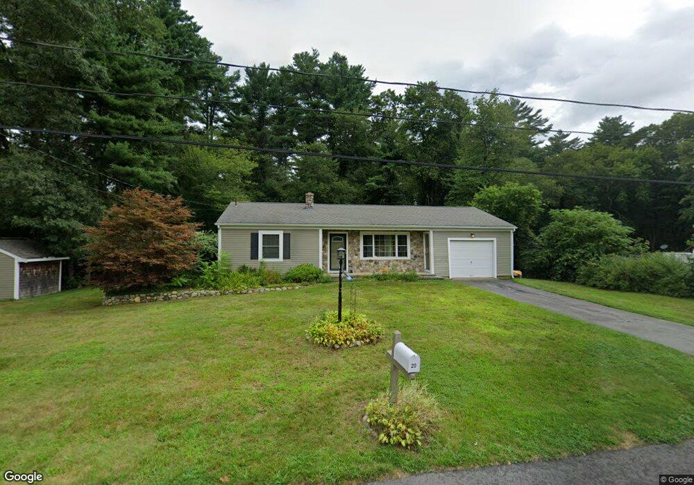
20 Johnson St Westport, MA 02790
North Westport NeighborhoodEstimated Value: $399,000 - $481,000
2
Beds
--
Bath
993
Sq Ft
$430/Sq Ft
Est. Value
About This Home
This home is located at 20 Johnson St, Westport, MA 02790 and is currently estimated at $427,250, approximately $430 per square foot. 20 Johnson St is a home located in Bristol County with nearby schools including Alice A. Macomber Primary School, Westport Elementary School, and Westport Middle-High School.
Ownership History
Date
Name
Owned For
Owner Type
Purchase Details
Closed on
Jun 25, 2021
Sold by
Watts Robin M and Carpenter William C
Bought by
Watts Robin M and Carpenter William C
Current Estimated Value
Purchase Details
Closed on
Mar 19, 2007
Sold by
Oliveira Jason R and Watts Robin M
Bought by
Watts Robin M and Carpenter William C
Home Financials for this Owner
Home Financials are based on the most recent Mortgage that was taken out on this home.
Original Mortgage
$105,000
Interest Rate
6.4%
Mortgage Type
Purchase Money Mortgage
Purchase Details
Closed on
Apr 5, 2005
Sold by
Oliveira Lucy M and Oliveira Madeline
Bought by
Oliveira Jason R and Oliveira Lucy M
Create a Home Valuation Report for This Property
The Home Valuation Report is an in-depth analysis detailing your home's value as well as a comparison with similar homes in the area
Home Values in the Area
Average Home Value in this Area
Purchase History
| Date | Buyer | Sale Price | Title Company |
|---|---|---|---|
| Watts Robin M | -- | None Available | |
| Watts Robin M | -- | -- | |
| Oliveira Jason R | -- | -- |
Source: Public Records
Mortgage History
| Date | Status | Borrower | Loan Amount |
|---|---|---|---|
| Previous Owner | Oliveira Jason R | $103,000 | |
| Previous Owner | Oliveira Jason R | $105,000 | |
| Previous Owner | Oliveira Jason R | $14,000 |
Source: Public Records
Tax History Compared to Growth
Tax History
| Year | Tax Paid | Tax Assessment Tax Assessment Total Assessment is a certain percentage of the fair market value that is determined by local assessors to be the total taxable value of land and additions on the property. | Land | Improvement |
|---|---|---|---|---|
| 2025 | $2,399 | $322,000 | $150,200 | $171,800 |
| 2024 | $2,386 | $308,700 | $139,200 | $169,500 |
| 2023 | $2,260 | $276,900 | $126,200 | $150,700 |
| 2022 | $2,104 | $248,100 | $119,900 | $128,200 |
| 2021 | $2,045 | $237,200 | $109,000 | $128,200 |
| 2020 | $1,917 | $227,400 | $99,200 | $128,200 |
| 2019 | $1,895 | $229,200 | $99,200 | $130,000 |
| 2018 | $1,491 | $182,500 | $86,300 | $96,200 |
| 2017 | $1,487 | $186,600 | $92,200 | $94,400 |
| 2016 | $1,400 | $177,000 | $87,500 | $89,500 |
| 2015 | $1,432 | $180,600 | $100,500 | $80,100 |
Source: Public Records
Map
Nearby Homes
- 15 S Breault St
- 16 S Berryman St
- 0 Van Buren St
- 9 Kyle Jacob Rd
- 565 Highland Ave
- 116 Gifford Rd
- 20 Faulkner St
- 27 Dias Ave
- 96 Forge Rd
- 1276 Old Fall River Rd
- 29 Union Ave
- 56 Lakeside Ave
- 100 D Dr
- 3 Diane Way
- 19 Charles Joseph Dr
- 55 Lakeside Ave
- 2 Donna Marie Dr
- 818 Reed Rd
- 735 Reed Rd
- 3 Roller Coaster Way Unit Lot 1