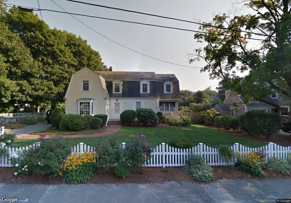
20 Keating Cir South Weymouth, MA 02190
South Weymouth NeighborhoodEstimated Value: $707,003 - $866,000
3
Beds
3
Baths
2,044
Sq Ft
$376/Sq Ft
Est. Value
About This Home
This home is located at 20 Keating Cir, South Weymouth, MA 02190 and is currently estimated at $768,751, approximately $376 per square foot. 20 Keating Cir is a home located in Norfolk County with nearby schools including Thomas V Nash, Abigail Adams Middle School, and Weymouth Middle School Chapman.
Ownership History
Date
Name
Owned For
Owner Type
Purchase Details
Closed on
Mar 25, 2020
Sold by
Quinn Rt
Bought by
Birolini Daniel P and Birolini Ellen B
Current Estimated Value
Create a Home Valuation Report for This Property
The Home Valuation Report is an in-depth analysis detailing your home's value as well as a comparison with similar homes in the area
Home Values in the Area
Average Home Value in this Area
Purchase History
| Date | Buyer | Sale Price | Title Company |
|---|---|---|---|
| Birolini Daniel P | $525,000 | None Available |
Source: Public Records
Tax History Compared to Growth
Tax History
| Year | Tax Paid | Tax Assessment Tax Assessment Total Assessment is a certain percentage of the fair market value that is determined by local assessors to be the total taxable value of land and additions on the property. | Land | Improvement |
|---|---|---|---|---|
| 2025 | $5,761 | $570,400 | $226,300 | $344,100 |
| 2024 | $5,593 | $544,600 | $215,500 | $329,100 |
| 2023 | $5,481 | $524,500 | $217,700 | $306,800 |
| 2022 | $5,374 | $468,900 | $201,600 | $267,300 |
| 2021 | $5,344 | $455,200 | $201,600 | $253,600 |
| 2020 | $5,164 | $433,200 | $201,600 | $231,600 |
| 2019 | $5,046 | $416,300 | $193,800 | $222,500 |
| 2018 | $4,904 | $392,300 | $184,600 | $207,700 |
| 2017 | $4,797 | $374,500 | $175,800 | $198,700 |
| 2016 | $4,617 | $360,700 | $169,100 | $191,600 |
| 2015 | $4,454 | $345,300 | $169,100 | $176,200 |
| 2014 | $4,285 | $322,200 | $157,300 | $164,900 |
Source: Public Records
Map
Nearby Homes
- 18 Fountain Ln Unit 2
- 120 Randolph St
- 50 Hollis St
- 45 Union St
- 60 Greentree Ln Unit 38
- 27 Park Ave
- 55 Greentree Ln Unit 19
- 193 Randolph St
- 7 Woodcrest Ct Unit 4
- 211 Randolph St
- 11 Woodcrest Ct Unit 5
- 10 Woodcrest Ct Unit 4
- 8 Woodcrest Ct Unit 4
- 25 Wales Ave
- 261 Pleasant St Unit 3
- 261 Pleasant St Unit 5
- 102 White St
- 2 Mitchell Ln Unit B
- 24 Fisher Rd
- 16 Jay Rd
- 28 Keating Cir
- 27 Roberts Dr
- 35 Roberts Dr
- 19 Roberts Dr
- 15 Keating Cir
- 16 Keating Cir
- 27 Keating Cir
- 36 Keating Cir
- 32 Roberts Dr
- 30 Roberts Dr Unit 1
- 10 Keating Cir
- 33 Keating Cir
- 26 Roberts Dr
- 937 Main St Unit 3
- 937 Main St Unit 1
- 38 Newbert Ave
- 40 Roberts Dr
- 42 Keating Cir
- 22 Newbert Ave
- 49 Roberts Dr