
Seller's Agent in 2018
Kelly Wilson
Adaro Realty, Inc.
(901) 461-9510
25 Total Sales
Estimated Value: $52,000 - $708,000
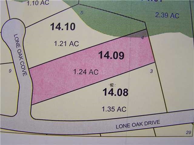
This home is located at 20 Lone Oak Cove, Eads, TN 38028 since 07 November 2015 and is currently estimated at $277,667. 20 Lone Oak Cove is a home located in Fayette County with nearby schools including Southwest Elementary School, West Junior High School, and Fayette Ware Comprehensive High School.
Last Agent to Sell the Property
Adaro Realty, Inc. License #256291 Listed on: 11/07/2015
| Date | Buyer | Sale Price | Title Company |
|---|---|---|---|
| Fayette County Investment Company Llc | -- | -- |
| Date | Event | Price | List to Sale | Price per Sq Ft |
|---|---|---|---|---|
| 08/02/2018 08/02/18 | Sold | $33,500 | -22.1% | -- |
| 07/01/2018 07/01/18 | Pending | -- | -- | -- |
| 11/07/2015 11/07/15 | For Sale | $43,000 | -- | -- |
| Year | Tax Paid | Tax Assessment Tax Assessment Total Assessment is a certain percentage of the fair market value that is determined by local assessors to be the total taxable value of land and additions on the property. | Land | Improvement |
|---|---|---|---|---|
| 2025 | $138 | $17,625 | $17,625 | -- |
| 2024 | $138 | $10,700 | $10,700 | -- |
| 2023 | $138 | $10,700 | $0 | $0 |
| 2022 | $138 | $10,700 | $10,700 | $0 |
| 2021 | $138 | $10,700 | $10,700 | $0 |
| 2020 | $146 | $10,700 | $10,700 | $0 |
| 2019 | $146 | $9,700 | $9,700 | $0 |
| 2018 | $146 | $9,700 | $9,700 | $0 |
| 2017 | $146 | $9,700 | $9,700 | $0 |
| 2016 | $156 | $9,700 | $9,700 | $0 |
| 2015 | $156 | $9,700 | $9,700 | $0 |
| 2014 | $156 | $9,700 | $9,700 | $0 |
Seller's Agent in 2018
Kelly Wilson
Adaro Realty, Inc.
(901) 461-9510
25 Total Sales
Buyer's Agent in 2018
Betty Carter
Crye-Leike
(901) 503-1263
74 Total Sales
Source: Memphis Area Association of REALTORS®
MLS Number: 9965004
APN: 105-014.09
Disclaimer: Certain information contained herein is derived from information provided by parties other than Homes.com. All information provided is deemed reliable, but is not guaranteed to be accurate and should be independently verified.
![]() Listing content and images Copyright 2025 Memphis Area Association of REALTORS®. Information provided is for the consumer’s personal, non-commercial use and may not be used for any purpose other than to identify prospective properties consumers may be interested in purchasing. Do not rely upon listing data without independently verifying it.
Listing content and images Copyright 2025 Memphis Area Association of REALTORS®. Information provided is for the consumer’s personal, non-commercial use and may not be used for any purpose other than to identify prospective properties consumers may be interested in purchasing. Do not rely upon listing data without independently verifying it.
Some or all of the listings displayed may not belong to the firm whose website is being visited.