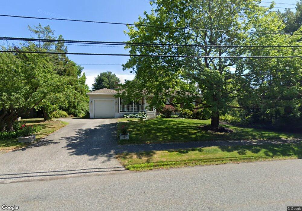
20 Lyman Rd Framingham, MA 01701
Nobscot NeighborhoodEstimated Value: $680,000 - $767,000
3
Beds
2
Baths
1,304
Sq Ft
$541/Sq Ft
Est. Value
About This Home
This home is located at 20 Lyman Rd, Framingham, MA 01701 and is currently estimated at $705,551, approximately $541 per square foot. 20 Lyman Rd is a home located in Middlesex County with nearby schools including Framingham High School, MetroWest Jewish Day School, and Summit Montessori School.
Ownership History
Date
Name
Owned For
Owner Type
Purchase Details
Closed on
May 15, 1998
Sold by
Williams Frank D and Williams Linda J
Bought by
Vrana Helaine
Current Estimated Value
Home Financials for this Owner
Home Financials are based on the most recent Mortgage that was taken out on this home.
Original Mortgage
$75,000
Outstanding Balance
$14,629
Interest Rate
7.08%
Mortgage Type
Purchase Money Mortgage
Estimated Equity
$690,922
Purchase Details
Closed on
Jun 12, 1996
Sold by
Jacobs David M and Jacobs Jill S
Bought by
Williams Frank D and Williams Linda J
Home Financials for this Owner
Home Financials are based on the most recent Mortgage that was taken out on this home.
Original Mortgage
$147,000
Interest Rate
7.97%
Mortgage Type
Purchase Money Mortgage
Create a Home Valuation Report for This Property
The Home Valuation Report is an in-depth analysis detailing your home's value as well as a comparison with similar homes in the area
Home Values in the Area
Average Home Value in this Area
Purchase History
| Date | Buyer | Sale Price | Title Company |
|---|---|---|---|
| Vrana Helaine | $225,000 | -- | |
| Vrana Helaine | $225,000 | -- | |
| Williams Frank D | $185,000 | -- | |
| Williams Frank D | $185,000 | -- |
Source: Public Records
Mortgage History
| Date | Status | Borrower | Loan Amount |
|---|---|---|---|
| Open | Williams Frank D | $75,000 | |
| Closed | Williams Frank D | $75,000 | |
| Previous Owner | Williams Frank D | $147,000 |
Source: Public Records
Tax History Compared to Growth
Tax History
| Year | Tax Paid | Tax Assessment Tax Assessment Total Assessment is a certain percentage of the fair market value that is determined by local assessors to be the total taxable value of land and additions on the property. | Land | Improvement |
|---|---|---|---|---|
| 2025 | $7,519 | $629,700 | $271,100 | $358,600 |
| 2024 | $7,253 | $582,100 | $242,200 | $339,900 |
| 2023 | $6,874 | $525,100 | $216,100 | $309,000 |
| 2022 | $6,521 | $474,600 | $196,100 | $278,500 |
| 2021 | $6,335 | $450,900 | $188,500 | $262,400 |
| 2020 | $6,395 | $426,900 | $171,300 | $255,600 |
| 2019 | $6,237 | $405,500 | $171,300 | $234,200 |
| 2018 | $6,171 | $378,100 | $164,900 | $213,200 |
| 2017 | $6,037 | $361,300 | $160,100 | $201,200 |
| 2016 | $5,989 | $344,600 | $160,100 | $184,500 |
| 2015 | $5,866 | $329,200 | $160,700 | $168,500 |
Source: Public Records
Map
Nearby Homes
- 36 Ruthellen Rd
- 32 Lyman Rd
- 769 Edgell Rd
- 484 Edgell Rd
- 18 Lomas Dr
- 641 Grove St
- 30 Elda Rd
- 301 Winch St
- 337 Edgell Rd
- 270 Edmands Rd
- 4 Pioneer Rd Unit 4
- 111 Higgins Rd
- 7 Pioneer Rd Unit 7
- 5 Pioneer Rd Unit 5
- 21 Blackberry Ln
- 9 Hawk Ln Unit 28
- 18 Eagle Ln Unit 21
- Arcadia Plan at Millwood Preserve
- 401 Belknap Rd
- 1 Brookvale Rd