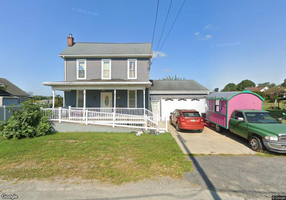
20 Main St Marietta, PA 17547
Estimated Value: $241,000 - $294,000
3
Beds
1
Bath
1,344
Sq Ft
$195/Sq Ft
Est. Value
About This Home
This home is located at 20 Main St, Marietta, PA 17547 and is currently estimated at $262,466, approximately $195 per square foot. 20 Main St is a home located in Lancaster County with nearby schools including Donegal Intermediate School, Donegal High School, and Susquehanna Waldorf School.
Ownership History
Date
Name
Owned For
Owner Type
Purchase Details
Closed on
Sep 29, 2005
Sold by
Brodhecker David Lee and Brodhecker Deborah Meyers
Bought by
Gusler Brett Allen and Kearney Nancy Catherine
Current Estimated Value
Home Financials for this Owner
Home Financials are based on the most recent Mortgage that was taken out on this home.
Original Mortgage
$114,900
Outstanding Balance
$56,544
Interest Rate
4.5%
Mortgage Type
Seller Take Back
Estimated Equity
$205,922
Create a Home Valuation Report for This Property
The Home Valuation Report is an in-depth analysis detailing your home's value as well as a comparison with similar homes in the area
Home Values in the Area
Average Home Value in this Area
Purchase History
| Date | Buyer | Sale Price | Title Company |
|---|---|---|---|
| Gusler Brett Allen | $115,000 | -- |
Source: Public Records
Mortgage History
| Date | Status | Borrower | Loan Amount |
|---|---|---|---|
| Open | Gusler Brett Allen | $114,900 |
Source: Public Records
Tax History Compared to Growth
Tax History
| Year | Tax Paid | Tax Assessment Tax Assessment Total Assessment is a certain percentage of the fair market value that is determined by local assessors to be the total taxable value of land and additions on the property. | Land | Improvement |
|---|---|---|---|---|
| 2025 | $3,183 | $125,300 | $41,700 | $83,600 |
| 2024 | $3,183 | $125,300 | $41,700 | $83,600 |
| 2023 | $3,171 | $125,300 | $41,700 | $83,600 |
| 2022 | $3,147 | $125,300 | $41,700 | $83,600 |
| 2021 | $3,088 | $125,300 | $41,700 | $83,600 |
| 2020 | $3,088 | $125,300 | $41,700 | $83,600 |
| 2019 | $3,032 | $125,300 | $41,700 | $83,600 |
| 2018 | $2,148 | $125,300 | $41,700 | $83,600 |
| 2017 | $3,371 | $111,800 | $32,900 | $78,900 |
| 2016 | $3,371 | $111,800 | $32,900 | $78,900 |
| 2015 | $859 | $111,800 | $32,900 | $78,900 |
| 2014 | $2,333 | $111,800 | $32,900 | $78,900 |
Source: Public Records
Map
Nearby Homes
- 18 S River St
- 12 Church St
- 18 S Queen St
- 87 Wild Cherry Ln
- 238 Chelmsford Dr
- 210 Abbey Dr
- 361 Wild Cherry Ln
- 85 Chelmsford Dr
- 50 Asbury Ct
- Lot 6 River Dr
- 115 Abbey Dr
- 20 Burberry Ln
- 676 W Market St
- 419 Coffee Goss Rd
- 219 Coffee Goss Rd
- 223 Coffee Goss Rd
- 518 W Market St
- 258 W Fairview Ave
- 2121 River Rd
- 105 N Waterford Ave