


20 Moro Dr Trenton, NJ 08619
University City NeighborhoodEstimated payment $4,405/month
Highlights
- Colonial Architecture
- Wood Flooring
- Great Room
- Recreation Room
- Attic
- No HOA
About This Home
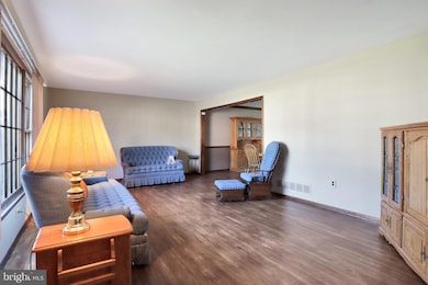
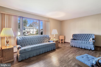
Beautiful Colonial in University Heights – Hamilton Township, NJ Welcome to this well-maintained 4-bedroom, 2.5-bath colonial located in the desirable University Heights neighborhood of Hamilton Township. This three-story home, including a finished basement, combines classic charm with thoughtful updates throughout . A brick-paved walkway and manicured front lawn create a warm first impression leading to the partial front porch . Inside, you’re greeted by a ceramic-tiled foyer with a double-door coat closet and a lovely staircase to the second level . The formal living and dining rooms feature hardwood floors, while bay windows in both the dining area and kitchen fill the space with natural light . The kitchen offers beautiful oak cabinetry, abundant storage, an island, Silestone countertops, and a tasteful backsplash — perfect for everyday use and entertaining alike . Just off the kitchen is a spacious recreational/living room featuring a full brick wall with a mantel and fireplace . The fireplace is currently closed but can be reopened at the buyer’s preference and expense; the seller is offering a brand-new electric insert and trim kit option . From the recreational/living room, sliding glass doors lead to a large Trex deck and a beautifully maintained backyard . The property also includes front and rear sprinkler systems for easy lawn care . Upstairs, the primary ensuite is spacious and includes a walk-in closet and private full bath . Three additional bedrooms are generously sized and share a well-appointed hall bath. The second level also features a whole-house fan for added comfort . The finished basement provides additional flexible living space — perfect for a recreation room, home gym, or office . Other highlights include an attached two-car garage with electric door openers , a driveway with room for four cars, and numerous updates made by the seller through the years, including the roof, air conditioning, heating system, Trex deck, kitchen counters and flooring, appliances, garage doors/openers, driveway, windows, fencing, leaf filters, and hot water heater . Freshly painted in a neutral palette and meticulously cared for, this home offers comfort, space, and timeless appeal — all in a sought-after neighborhood close to parks, schools, restaurants, and major commuter routes .
Listing Agent
(848) 203-2432 michele-gomez@hotmail.com Moverite Real Estate, LLC Listed on: 10/29/2025
Home Details
Home Type
- Single Family
Est. Annual Taxes
- $12,473
Year Built
- Built in 1979
Lot Details
- 9,888 Sq Ft Lot
- Lot Dimensions are 86.00 x 115.00
- Property is Fully Fenced
- Vinyl Fence
- Property is in very good condition
Parking
- 2 Car Direct Access Garage
- 4 Driveway Spaces
- Parking Storage or Cabinetry
- Front Facing Garage
- Garage Door Opener
- On-Street Parking
Home Design
- Colonial Architecture
- Brick Exterior Construction
- Block Foundation
- Shingle Roof
- Asphalt Roof
- Vinyl Siding
- Active Radon Mitigation
Interior Spaces
- 2,252 Sq Ft Home
- Property has 3 Levels
- Fireplace Mantel
- Brick Fireplace
- Entrance Foyer
- Great Room
- Dining Room
- Recreation Room
- Finished Basement
- Basement Fills Entire Space Under The House
- Attic Fan
Flooring
- Wood
- Carpet
- Ceramic Tile
Bedrooms and Bathrooms
- 4 Bedrooms
Schools
- University Heights Elementary School
- Crockett Middle School
- Nottingham High School
Utilities
- Central Heating and Cooling System
- Cooling System Utilizes Natural Gas
- Natural Gas Water Heater
Community Details
- No Home Owners Association
- University Heights Subdivision
Listing and Financial Details
- Tax Lot 00018
- Assessor Parcel Number 03-01552-00018
Map
Home Values in the Area
Average Home Value in this Area
Tax History
| Year | Tax Paid | Tax Assessment Tax Assessment Total Assessment is a certain percentage of the fair market value that is determined by local assessors to be the total taxable value of land and additions on the property. | Land | Improvement |
|---|---|---|---|---|
| 2025 | $11,855 | $336,400 | $95,900 | $240,500 |
| 2024 | $11,111 | $336,400 | $95,900 | $240,500 |
| 2023 | $11,111 | $336,400 | $95,900 | $240,500 |
| 2022 | $10,936 | $336,400 | $95,900 | $240,500 |
| 2021 | $11,986 | $336,400 | $95,900 | $240,500 |
| 2020 | $10,775 | $336,400 | $95,900 | $240,500 |
| 2019 | $10,513 | $336,400 | $95,900 | $240,500 |
| 2018 | $10,388 | $336,400 | $95,900 | $240,500 |
| 2017 | $10,166 | $336,400 | $95,900 | $240,500 |
| 2016 | $9,096 | $336,400 | $95,900 | $240,500 |
| 2015 | $9,484 | $199,700 | $58,800 | $140,900 |
| 2014 | $9,348 | $199,700 | $58,800 | $140,900 |
Property History
| Date | Event | Price | List to Sale | Price per Sq Ft |
|---|---|---|---|---|
| 10/29/2025 10/29/25 | For Sale | $639,900 | -- | $284 / Sq Ft |
Purchase History
| Date | Type | Sale Price | Title Company |
|---|---|---|---|
| Quit Claim Deed | -- | -- | |
| Deed | $222,000 | -- |
Mortgage History
| Date | Status | Loan Amount | Loan Type |
|---|---|---|---|
| Previous Owner | $75,000 | Purchase Money Mortgage |
Source: Bright MLS
MLS Number: NJME2069088
APN: 03-01552-0000-00018
Disclaimer: Certain information contained herein is derived from information provided by parties other than Homes.com. All information provided is deemed reliable, but is not guaranteed to be accurate and should be independently verified.
![]() The data relating to real estate for sale on this website appears in part through the BRIGHT Internet Data Exchange program, a voluntary cooperative exchange of property listing data between licensed real estate brokerage firms, and is provided by BRIGHT through a licensing agreement.
The data relating to real estate for sale on this website appears in part through the BRIGHT Internet Data Exchange program, a voluntary cooperative exchange of property listing data between licensed real estate brokerage firms, and is provided by BRIGHT through a licensing agreement.
Listing information is from various brokers who participate in the Bright MLS IDX program and not all listings may be visible on the site.
The property information being provided on or through the website is for the personal, non-commercial use of consumers and such information may not be used for any purpose other than to identify prospective properties consumers may be interested in purchasing.
Some properties which appear for sale on the website may no longer be available because they are for instance, under contract, sold or are no longer being offered for sale.
Property information displayed is deemed reliable but is not guaranteed.
Copyright 2025 Bright MLS, Inc.
- 95 Terrill Ave
- 126 Cooney Ave
- 414 Flock Rd
- 18 Wolfpack Rd
- 10 Whitman Rd
- 583 Edinburg Rd Unit MER
- 397 Edinburg Rd Unit MER
- 18 Monroe Dr
- 47 Wesleyan Dr
- 13 Blairmore Dr
- 69 Corson Ave
- 35 Wesleyan Dr
- 104 Robin Dr
- 7 Pinehurst Ct
- 26 Coral Dr
- 10 Wolfpack Ct
- 8 Samantha Ln
- 17 Samantha Ln
- 924 Hughes Dr
- 542 Mercerville-Edinburg Rd
- 145 Brookwood Rd
- 1007 Hughes Dr
- 265 Edinburg Rd Unit MER
- 121 Hoover Ave
- 153 Sheridan Rd
- 1321 Sierra Dr
- 1322 Sierra Dr Unit 1322
- 900 Grand Central Dr
- 1314 Sierra Dr Unit 1314 Sierra Drive
- 1338 Sierra Dr
- 6 Kite Ct
- 1047 Halifax Place
- 1137 Halifax Place
- 735 Grand Central Dr
- 1443 Sierra Dr
- 917 Halifax Place
- 923 Halifax Place
- 72 Joyner Ct
- 31 Oneill Ct
- 6 Harris Ct
