Estimated Value: $238,000 - $284,984
3
Beds
2
Baths
1,817
Sq Ft
$149/Sq Ft
Est. Value
About This Home
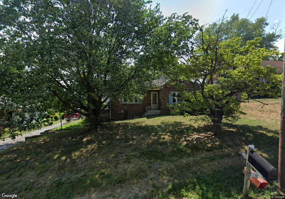
This home is located at 20 N Emigs Mill Rd, York, PA 17408 and is currently estimated at $270,246, approximately $148 per square foot. 20 N Emigs Mill Rd is a home located in York County with nearby schools including West York Area High School, Lincoln Charter School, and St Rose Of Lima School.
Ownership History
Date
Name
Owned For
Owner Type
Purchase Details
Closed on
Jun 29, 1999
Sold by
Hartlaub Donald E and Hartlaub Sandra A
Bought by
Scott William F and Scott Cheryl A
Current Estimated Value
Home Financials for this Owner
Home Financials are based on the most recent Mortgage that was taken out on this home.
Original Mortgage
$112,098
Outstanding Balance
$30,483
Interest Rate
7.19%
Mortgage Type
VA
Estimated Equity
$239,763
Purchase Details
Closed on
Feb 19, 1991
Bought by
Hartlaub Donald E and Hartlaub Sandra A
Create a Home Valuation Report for This Property
The Home Valuation Report is an in-depth analysis detailing your home's value as well as a comparison with similar homes in the area
Home Values in the Area
Average Home Value in this Area
Purchase History
| Date | Buyer | Sale Price | Title Company |
|---|---|---|---|
| Scott William F | $109,900 | -- | |
| Hartlaub Donald E | -- | -- |
Source: Public Records
Mortgage History
| Date | Status | Borrower | Loan Amount |
|---|---|---|---|
| Open | Scott William F | $112,098 |
Source: Public Records
Tax History Compared to Growth
Tax History
| Year | Tax Paid | Tax Assessment Tax Assessment Total Assessment is a certain percentage of the fair market value that is determined by local assessors to be the total taxable value of land and additions on the property. | Land | Improvement |
|---|---|---|---|---|
| 2025 | $4,438 | $131,600 | $36,970 | $94,630 |
| 2024 | $4,326 | $131,600 | $36,970 | $94,630 |
| 2023 | $4,326 | $131,600 | $36,970 | $94,630 |
| 2022 | $4,326 | $131,600 | $36,970 | $94,630 |
| 2021 | $4,195 | $131,600 | $36,970 | $94,630 |
| 2020 | $4,195 | $131,600 | $36,970 | $94,630 |
| 2019 | $4,116 | $131,600 | $36,970 | $94,630 |
| 2018 | $4,083 | $131,600 | $36,970 | $94,630 |
| 2017 | $3,958 | $131,600 | $36,970 | $94,630 |
| 2016 | $0 | $131,600 | $36,970 | $94,630 |
| 2015 | -- | $131,600 | $36,970 | $94,630 |
| 2014 | -- | $131,600 | $36,970 | $94,630 |
Source: Public Records
Map
Nearby Homes
- 4160 W Market St
- 4125 W Market St
- 4325 W Market St
- 4075 Rolling Meadow Ct
- 4415 A W Market St
- 4001 Rolling Meadow Ct
- 4070 Rolling Meadow Ct
- 105 Margate Rd
- 0 Trinity Rd Unit PAYK2057290
- 4650 Wolfs Church Rd
- 410 Hanover Rd
- 5 Shennys Dr
- 625 Bairs Rd
- 665 Bairs Rd
- 0 Baker Rd Unit PAYK2023686
- 3987 Little John Dr
- 3984 Little John Dr
- 238 Perry Ave
- 1036 Smith Hill Rd
- 652 Stoverstown Rd
- 30 N Emigs Mill Rd
- 10 N Emigs Mill Rd
- 51 N Emigs Mill Rd
- 4205 W Market St
- 4205 W Market St
- 4215 W Market St
- 4225 W Market St
- 4195 W Market St
- 4245 W Market St
- 4 Lawson Ct
- 68 Lawson Ct
- 4267 W Market St
- 18 Lawson Ct
- 16 Lawson Ct
- 22 Lawson Ct
- 43 Lawson Ct
- 45 Lawson Ct
- 35 N Alwine Ave
- 25 N Alwine Ave
- 4285 W Market St