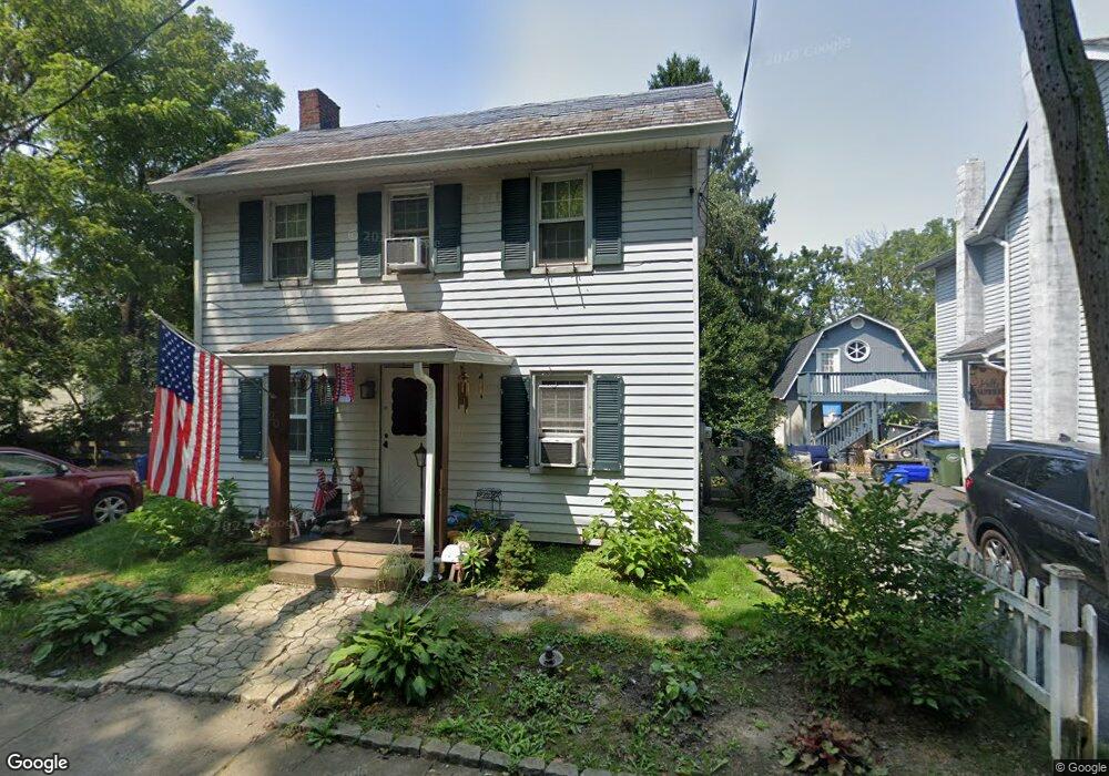
20 North St Bloomsbury, NJ 08804
Estimated Value: $228,382 - $333,000
--
Bed
--
Bath
1,188
Sq Ft
$246/Sq Ft
Est. Value
About This Home
This home is located at 20 North St, Bloomsbury, NJ 08804 and is currently estimated at $291,846, approximately $245 per square foot. 20 North St is a home located in Hunterdon County with nearby schools including Bloomsbury Elementary School.
Ownership History
Date
Name
Owned For
Owner Type
Purchase Details
Closed on
Jun 29, 2005
Sold by
Dopp Terrance M and Dopp Erin C
Bought by
Tufaro John
Current Estimated Value
Home Financials for this Owner
Home Financials are based on the most recent Mortgage that was taken out on this home.
Original Mortgage
$190,000
Outstanding Balance
$99,502
Interest Rate
5.71%
Mortgage Type
Stand Alone First
Estimated Equity
$192,344
Purchase Details
Closed on
Dec 30, 1999
Sold by
Vezza Mary
Bought by
Dopp Terrance M and Lynch Erin C
Home Financials for this Owner
Home Financials are based on the most recent Mortgage that was taken out on this home.
Original Mortgage
$108,000
Interest Rate
7.71%
Purchase Details
Closed on
Jul 2, 1990
Sold by
Good Nancy
Bought by
Vezza Mary
Create a Home Valuation Report for This Property
The Home Valuation Report is an in-depth analysis detailing your home's value as well as a comparison with similar homes in the area
Home Values in the Area
Average Home Value in this Area
Purchase History
| Date | Buyer | Sale Price | Title Company |
|---|---|---|---|
| Tufaro John | $220,000 | -- | |
| Dopp Terrance M | $120,000 | -- | |
| Vezza Mary | $105,000 | -- |
Source: Public Records
Mortgage History
| Date | Status | Borrower | Loan Amount |
|---|---|---|---|
| Open | Tufaro John | $190,000 | |
| Previous Owner | Dopp Terrance M | $108,000 |
Source: Public Records
Tax History Compared to Growth
Tax History
| Year | Tax Paid | Tax Assessment Tax Assessment Total Assessment is a certain percentage of the fair market value that is determined by local assessors to be the total taxable value of land and additions on the property. | Land | Improvement |
|---|---|---|---|---|
| 2025 | $5,241 | $148,000 | $44,400 | $103,600 |
| 2024 | $5,019 | $148,000 | $44,400 | $103,600 |
| 2023 | $5,019 | $148,000 | $44,400 | $103,600 |
| 2022 | $4,853 | $148,000 | $44,400 | $103,600 |
| 2021 | $4,489 | $148,000 | $44,400 | $103,600 |
| 2020 | $4,638 | $148,000 | $44,400 | $103,600 |
| 2019 | $4,489 | $148,000 | $44,400 | $103,600 |
| 2018 | $4,397 | $148,000 | $44,400 | $103,600 |
| 2017 | $4,353 | $148,000 | $44,400 | $103,600 |
| 2016 | $4,231 | $148,000 | $44,400 | $103,600 |
| 2015 | $4,141 | $148,000 | $44,400 | $103,600 |
| 2014 | $4,543 | $201,300 | $91,800 | $109,500 |
Source: Public Records
Map
Nearby Homes
- 1 Woodland Terrace
- 63 Main St
- 705 Warren Glen Rd
- 908 Maple Dr
- 103 Roberts Place
- 402 Parker Rd
- 14 Tulip Ln
- 204 Aldin Rd
- 101 Parker Rd
- 268 County Road 579
- 333 Greens Ridge Rd
- 2141 New Village Rd
- 104 Fox Run Rd
- 285 County Road 579
- 716 Sweet Hollow Rd
- 319 Sweet Hollow Rd
- 358 Bloomsbury Rd
- 668 S Main St Unit 1
- 579 Goritz Rd
- 00 Sweet Hollow Rd