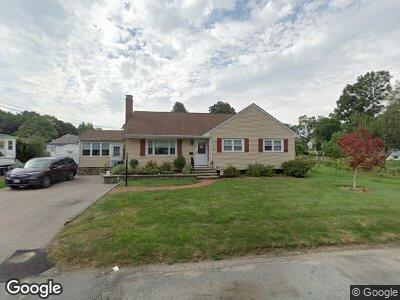
20 Norton Ave Walpole, MA 02081
Estimated Value: $637,000 - $681,000
4
Beds
2
Baths
1,666
Sq Ft
$400/Sq Ft
Est. Value
About This Home
This home is located at 20 Norton Ave, Walpole, MA 02081 and is currently estimated at $666,422, approximately $400 per square foot. 20 Norton Ave is a home located in Norfolk County with nearby schools including Fisher School, Bird Middle School, and Walpole High School.
Ownership History
Date
Name
Owned For
Owner Type
Purchase Details
Closed on
Oct 7, 2020
Sold by
Marino Pasquale J and Dockery Patricia
Bought by
Dockery Patricia A and Dockery Kevin J
Current Estimated Value
Purchase Details
Closed on
Mar 16, 2012
Sold by
Marino Pasquale J
Bought by
Dockery Patricia
Create a Home Valuation Report for This Property
The Home Valuation Report is an in-depth analysis detailing your home's value as well as a comparison with similar homes in the area
Home Values in the Area
Average Home Value in this Area
Purchase History
| Date | Buyer | Sale Price | Title Company |
|---|---|---|---|
| Dockery Patricia A | -- | None Available | |
| Dockery Patricia | -- | -- |
Source: Public Records
Mortgage History
| Date | Status | Borrower | Loan Amount |
|---|---|---|---|
| Previous Owner | Marino Pasquale J | $158,100 | |
| Previous Owner | Marino Pasquale J | $153,000 | |
| Previous Owner | Marino Pasquale J | $131,000 | |
| Previous Owner | Marino Pasquale J | $93,500 |
Source: Public Records
Tax History Compared to Growth
Tax History
| Year | Tax Paid | Tax Assessment Tax Assessment Total Assessment is a certain percentage of the fair market value that is determined by local assessors to be the total taxable value of land and additions on the property. | Land | Improvement |
|---|---|---|---|---|
| 2025 | $7,158 | $557,900 | $286,000 | $271,900 |
| 2024 | $6,894 | $521,500 | $275,000 | $246,500 |
| 2023 | $6,638 | $477,900 | $239,100 | $238,800 |
| 2022 | $6,283 | $434,500 | $221,400 | $213,100 |
| 2021 | $5,884 | $396,500 | $208,900 | $187,600 |
| 2020 | $5,768 | $384,800 | $197,000 | $187,800 |
| 2019 | $5,620 | $372,200 | $189,500 | $182,700 |
| 2018 | $5,424 | $355,200 | $182,100 | $173,100 |
| 2017 | $5,261 | $343,200 | $175,100 | $168,100 |
| 2016 | $5,211 | $334,900 | $168,400 | $166,500 |
| 2015 | $5,077 | $323,400 | $160,100 | $163,300 |
| 2014 | $4,815 | $305,500 | $160,100 | $145,400 |
Source: Public Records
Map
Nearby Homes
- 881 Main St Unit 4
- 1410 Pennington Dr Unit 1410
- 3303 Pennington Dr Unit 3303
- 3111 Pennington Dr Unit 3111
- 979 Main St Unit 6
- 979 Main St Unit 5
- 979 Main St Unit 4
- 979 Main St Unit 3
- 979 Main St Unit 2
- 979 Main St Unit 1
- 979 Main St Unit 8
- 224 School St Unit 4
- 15 Helen Ln
- 30 Forsythia Dr
- 16 Red Gate Rd
- 38 Riverside Place
- 15 Day Lily Ln
- 11 South St
- 22 Holly Rd
- 9 Garden Terrace
- 20 Norton Ave
- 46 Norton Ave
- 4-6 Norton Ave
- 6 Norton Ave Unit 6
- 4 Norton Ave Unit 4
- 24 Wedgemere Ct
- 21 Wedgemere Ct
- 51 School St
- 15 Norton Ave Unit 17
- 19 Norton Ave Unit 21
- 19 Norton Ave Unit 19
- 19 Norton Ave Unit 2
- 11 Norton Ave Unit 13
- 19-21 Norton Ave
- 19-21 Norton Ave Unit 2
- 19-21 Norton Ave Unit 1
- 21 Norton Ave Unit 21
- 21 Norton Ave
- 21 Norton Ave Unit 2
- 63 School St