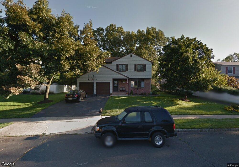
20 Pierson Dr Hillsborough, NJ 08844
Estimated Value: $685,000 - $736,000
--
Bed
--
Bath
2,184
Sq Ft
$324/Sq Ft
Est. Value
About This Home
This home is located at 20 Pierson Dr, Hillsborough, NJ 08844 and is currently estimated at $708,337, approximately $324 per square foot. 20 Pierson Dr is a home located in Somerset County with nearby schools including Hillsborough High School, Brighthorizons at Hillsborough, and Cherry Blossom Montessori School.
Ownership History
Date
Name
Owned For
Owner Type
Purchase Details
Closed on
Apr 3, 2008
Sold by
Lin Chiang Neng and Lin Hsiu Jung
Bought by
Vannest Donald and Van Nest Judith
Current Estimated Value
Home Financials for this Owner
Home Financials are based on the most recent Mortgage that was taken out on this home.
Original Mortgage
$300,000
Outstanding Balance
$190,928
Interest Rate
6.06%
Mortgage Type
Purchase Money Mortgage
Estimated Equity
$517,409
Create a Home Valuation Report for This Property
The Home Valuation Report is an in-depth analysis detailing your home's value as well as a comparison with similar homes in the area
Home Values in the Area
Average Home Value in this Area
Purchase History
| Date | Buyer | Sale Price | Title Company |
|---|---|---|---|
| Vannest Donald | $414,000 | None Available |
Source: Public Records
Mortgage History
| Date | Status | Borrower | Loan Amount |
|---|---|---|---|
| Open | Vannest Donald | $300,000 |
Source: Public Records
Tax History Compared to Growth
Tax History
| Year | Tax Paid | Tax Assessment Tax Assessment Total Assessment is a certain percentage of the fair market value that is determined by local assessors to be the total taxable value of land and additions on the property. | Land | Improvement |
|---|---|---|---|---|
| 2025 | $12,393 | $657,900 | $334,700 | $323,200 |
| 2024 | $12,393 | $578,300 | $319,700 | $258,600 |
| 2023 | $11,622 | $539,800 | $279,700 | $260,100 |
| 2022 | $11,357 | $508,600 | $279,700 | $228,900 |
| 2021 | $10,451 | $442,100 | $214,700 | $227,400 |
| 2020 | $10,451 | $438,400 | $209,700 | $228,700 |
| 2019 | $10,330 | $429,700 | $199,700 | $230,000 |
| 2018 | $10,063 | $416,000 | $184,700 | $231,300 |
| 2017 | $9,223 | $381,900 | $159,700 | $222,200 |
| 2016 | $8,826 | $365,600 | $142,200 | $223,400 |
| 2015 | $8,747 | $366,900 | $142,200 | $224,700 |
| 2014 | $8,883 | $380,600 | $142,200 | $238,400 |
Source: Public Records
Map
Nearby Homes
- 10 Staats Dr
- 180 Hollow Oak Ct
- 51 Balsam Ct
- 61 Wallace Blvd
- 91 Crickhollow Ct
- 45 Chetwood Ct
- 27 Chetwood Ct
- 204 Merry Ln
- 595 Auten Rd Unit 5
- 806 Eves Dr Unit 1B
- 597 Auten Rd Unit 2
- 807 Eves Dr Unit 1B
- 3512 Bloomingdale Dr
- 33 Bloomingdale Dr
- 35 Bloomingdale Dr
- 0-37-33 Bloomingdale Dr
- 3733 Bloomingdale Dr
- 7 Monfort Dr
- 3712 Bloomingdale Dr
- 3610 Royce Ct