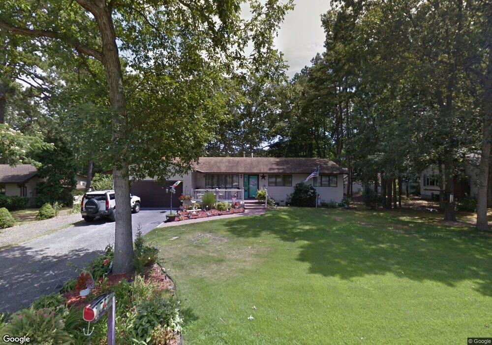
20 Pikes Peak Rd Little Egg Harbor Township, NJ 08087
Little Egg Harbor Township NeighborhoodEstimated Value: $331,574 - $443,000
3
Beds
2
Baths
1,472
Sq Ft
$268/Sq Ft
Est. Value
About This Home
This home is located at 20 Pikes Peak Rd, Little Egg Harbor Township, NJ 08087 and is currently estimated at $395,144, approximately $268 per square foot. 20 Pikes Peak Rd is a home located in Ocean County with nearby schools including Frog Pond Elementary School, Pinelands Regional Junior High School, and Pinelands Regional High School.
Ownership History
Date
Name
Owned For
Owner Type
Purchase Details
Closed on
Aug 29, 2025
Sold by
Savasta Dominick and Savasta Pauline
Bought by
Savasta Dominick and Savasta Pauline
Current Estimated Value
Home Financials for this Owner
Home Financials are based on the most recent Mortgage that was taken out on this home.
Original Mortgage
$76,000
Outstanding Balance
$76,000
Interest Rate
6.72%
Mortgage Type
New Conventional
Estimated Equity
$319,144
Create a Home Valuation Report for This Property
The Home Valuation Report is an in-depth analysis detailing your home's value as well as a comparison with similar homes in the area
Home Values in the Area
Average Home Value in this Area
Purchase History
| Date | Buyer | Sale Price | Title Company |
|---|---|---|---|
| Savasta Dominick | -- | Clearedge Title |
Source: Public Records
Mortgage History
| Date | Status | Borrower | Loan Amount |
|---|---|---|---|
| Open | Savasta Dominick | $76,000 |
Source: Public Records
Tax History Compared to Growth
Tax History
| Year | Tax Paid | Tax Assessment Tax Assessment Total Assessment is a certain percentage of the fair market value that is determined by local assessors to be the total taxable value of land and additions on the property. | Land | Improvement |
|---|---|---|---|---|
| 2025 | $5,532 | $186,700 | $77,300 | $109,400 |
| 2024 | $5,300 | $186,700 | $77,300 | $109,400 |
| 2023 | $5,134 | $186,700 | $77,300 | $109,400 |
| 2022 | $5,134 | $186,700 | $77,300 | $109,400 |
| 2021 | $4,282 | $186,700 | $77,300 | $109,400 |
| 2020 | $4,948 | $186,700 | $77,300 | $109,400 |
| 2019 | $4,748 | $186,700 | $77,300 | $109,400 |
| 2018 | $4,477 | $186,700 | $77,300 | $109,400 |
| 2017 | $4,408 | $186,700 | $77,300 | $109,400 |
| 2016 | $4,443 | $186,700 | $77,300 | $109,400 |
| 2015 | $4,498 | $186,700 | $77,300 | $109,400 |
| 2014 | $3,862 | $202,100 | $86,600 | $115,500 |
Source: Public Records
Map
Nearby Homes
- 67 Leitz Blvd
- 61 Leitz Blvd
- 58 Vincent Ct
- 72 Vincent Ct
- 153 Oakleaf Dr
- 14 Pelican Ln
- 645 U S Highway 9
- 742 State Route 9
- 24 Pelican Ln
- 126 Jefferson Ln
- 131 Jefferson Ln
- 60 Windstar Dr
- 370 Route 9 S
- 249 Center St
- 11 Marina Way
- 35 Nautic Way
- 105 Floyd Ln
- 111 W Holly Ln
- 5 Timberline Dr
- 19 Waters Edge Dr