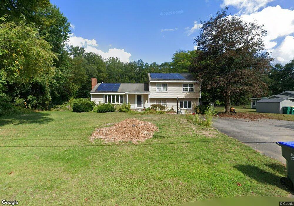
20 Pratt St Lunenburg, MA 01462
Estimated Value: $491,845 - $584,000
4
Beds
3
Baths
1,676
Sq Ft
$310/Sq Ft
Est. Value
About This Home
This home is located at 20 Pratt St, Lunenburg, MA 01462 and is currently estimated at $519,461, approximately $309 per square foot. 20 Pratt St is a home located in Worcester County with nearby schools including Lunenburg Primary School, Lunenburg High School, and St Bernards Elementary School.
Ownership History
Date
Name
Owned For
Owner Type
Purchase Details
Closed on
Jun 23, 2011
Sold by
Kondaur Capital Corp
Bought by
Harp Jay R
Current Estimated Value
Home Financials for this Owner
Home Financials are based on the most recent Mortgage that was taken out on this home.
Original Mortgage
$194,832
Outstanding Balance
$133,491
Interest Rate
4.5%
Mortgage Type
FHA
Estimated Equity
$385,970
Purchase Details
Closed on
Jul 29, 2010
Sold by
Saranovitz Brian H and Burpee Brenda L
Bought by
Kondaur Capital Corp
Purchase Details
Closed on
Oct 3, 2006
Sold by
Ghoul and Ghoul Jayne El
Bought by
Burpee Brenda L and Saranovitz Brian H
Purchase Details
Closed on
Dec 6, 1994
Sold by
Inhabitants Lunenburg
Bought by
Saranovitz Brian and Saranovitz Cynthia
Purchase Details
Closed on
Jun 11, 1993
Sold by
Saranovitz Norman S
Bought by
Saranovitz Brian H and Saranovitz Cindy
Create a Home Valuation Report for This Property
The Home Valuation Report is an in-depth analysis detailing your home's value as well as a comparison with similar homes in the area
Home Values in the Area
Average Home Value in this Area
Purchase History
| Date | Buyer | Sale Price | Title Company |
|---|---|---|---|
| Harp Jay R | $199,900 | -- | |
| Kondaur Capital Corp | $311,295 | -- | |
| Burpee Brenda L | -- | -- | |
| Saranovitz Brian | $2,500 | -- | |
| Saranovitz Brian H | $135,000 | -- |
Source: Public Records
Mortgage History
| Date | Status | Borrower | Loan Amount |
|---|---|---|---|
| Open | Saranovitz Brian H | $194,832 | |
| Previous Owner | Saranovitz Brian H | $252,000 |
Source: Public Records
Tax History Compared to Growth
Tax History
| Year | Tax Paid | Tax Assessment Tax Assessment Total Assessment is a certain percentage of the fair market value that is determined by local assessors to be the total taxable value of land and additions on the property. | Land | Improvement |
|---|---|---|---|---|
| 2025 | $6,195 | $431,400 | $139,500 | $291,900 |
| 2024 | $5,985 | $424,500 | $131,600 | $292,900 |
| 2023 | $5,817 | $397,900 | $119,600 | $278,300 |
| 2022 | $5,762 | $335,200 | $99,700 | $235,500 |
| 2020 | $6,092 | $336,200 | $99,800 | $236,400 |
| 2019 | $5,950 | $318,500 | $94,000 | $224,500 |
| 2018 | $5,443 | $276,300 | $94,000 | $182,300 |
| 2017 | $5,291 | $264,800 | $89,100 | $175,700 |
| 2016 | $4,889 | $249,300 | $84,800 | $164,500 |
| 2015 | $4,261 | $232,600 | $80,400 | $152,200 |
Source: Public Records
Map
Nearby Homes
- 3 Rennie St
- 819 West St
- 26 Otis St
- 44 Hamlin St
- 165 Summer St Unit Lot 2
- 471 North St
- 141 Pleasant St
- 3 Chase Ave
- 1479 Main St
- 0 Summer St
- 121 Morningside St Unit 121
- 452 Hollis Rd
- 9 Pleasant St
- 200-365 Hollis Rd
- 363 Lunenburg St
- 77 Upland Ave
- 15 Clyde St
- 2 Arden Mills Way Unit 2210
- 312 Boutelle St
- 20 Clyde St