


Estimated payment $3,210/month
Highlights
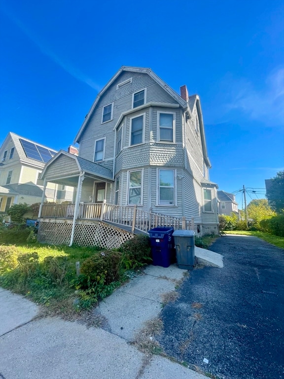
- Colonial Architecture
- Property is near public transit
- 3 Fireplaces
- Deck
- Wood Flooring
- 3-minute walk to Stanley-Bellevue Park
About This Home
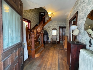
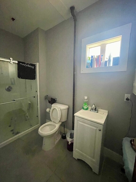
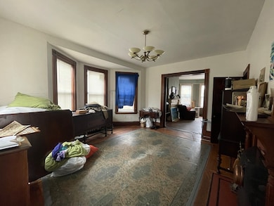
This classic 1910 Colonial, owned by the same family since its been built, sits on a 4688 sqft. fenced lot and is zoned for up to 3 units. With solid bones, and plenty of space to reimagine, this opportunity is ideal for investors or developers! Inside, you’ll find 3 levels of living space featuring a spacious living and dining room with original fireplaces, 5 generous bedrooms, and 2 full bathrooms & 2 Kitchens! The full basement offers additional potential for finishing or storage. Additional highlights include a new boiler and hot water heater, spacious backyard, 2 car driveway, ample on-street parking, and convenient access to public transportation, local shops, theaters and parks.This home offers endless possibilities for renovation, expansion, or multi-unit conversion (buyer to perform due diligence). Don’t miss this rare opportunity to bring new life to a property filled with history, heart, and potential! OFFER DEADLINE IS SET for 11/17/25 @ 5 PM.
Listing Agent
Jacqueline Fonseca
Greater Investments Listed on: 11/02/2025
Home Details
Home Type
- Single Family
Est. Annual Taxes
- $752
Year Built
- Built in 1910
Lot Details
- 4,688 Sq Ft Lot
- Fenced Yard
- Property is zoned 3F-5000
Home Design
- Colonial Architecture
Interior Spaces
- 2,634 Sq Ft Home
- 3 Fireplaces
- Bonus Room
- Wood Flooring
- Unfinished Basement
- Basement Fills Entire Space Under The House
Bedrooms and Bathrooms
- 5 Bedrooms
- Primary bedroom located on second floor
- 2 Full Bathrooms
Parking
- 2 Car Parking Spaces
- Driveway
- Paved Parking
- Open Parking
- Off-Street Parking
Accessible Home Design
- Level Entry For Accessibility
Outdoor Features
- Deck
- Porch
Location
- Property is near public transit
- Property is near schools
Utilities
- Window Unit Cooling System
- Heating System Uses Natural Gas
- Hot Water Heating System
- Heating System Uses Steam
Listing and Financial Details
- Assessor Parcel Number 1502782000,1301662
Community Details
Overview
- No Home Owners Association
Amenities
- Shops
- Coin Laundry
Recreation
- Park
Map
Home Values in the Area
Average Home Value in this Area
Tax History
| Year | Tax Paid | Tax Assessment Tax Assessment Total Assessment is a certain percentage of the fair market value that is determined by local assessors to be the total taxable value of land and additions on the property. | Land | Improvement |
|---|---|---|---|---|
| 2025 | $5,484 | $473,600 | $190,700 | $282,900 |
| 2024 | $4,920 | $451,400 | $185,400 | $266,000 |
| 2023 | $4,848 | $451,400 | $185,400 | $266,000 |
| 2022 | $4,549 | $418,100 | $171,700 | $246,400 |
| 2021 | $4,214 | $394,900 | $166,700 | $228,200 |
| 2020 | $3,833 | $363,000 | $158,900 | $204,100 |
| 2019 | $3,609 | $342,400 | $130,900 | $211,500 |
| 2018 | $3,353 | $319,900 | $130,900 | $189,000 |
| 2017 | $3,166 | $299,000 | $130,900 | $168,100 |
| 2016 | $3,289 | $299,000 | $130,900 | $168,100 |
| 2015 | $2,852 | $235,505 | $100,985 | $134,520 |
| 2014 | $2,835 | $225,340 | $100,985 | $124,355 |
Property History
| Date | Event | Price | List to Sale | Price per Sq Ft |
|---|---|---|---|---|
| 11/15/2025 11/15/25 | Pending | -- | -- | -- |
| 11/11/2025 11/11/25 | Price Changed | $600,000 | -7.7% | $228 / Sq Ft |
| 11/02/2025 11/02/25 | For Sale | $650,000 | -- | $247 / Sq Ft |
Purchase History
| Date | Type | Sale Price | Title Company |
|---|---|---|---|
| Quit Claim Deed | -- | None Available | |
| Deed | $35,000 | -- |
Mortgage History
| Date | Status | Loan Amount | Loan Type |
|---|---|---|---|
| Previous Owner | $15,000 | Purchase Money Mortgage |
Source: MLS Property Information Network (MLS PIN)
MLS Number: 73450444
APN: DORC-000000-000015-002782
Disclaimer: Certain information contained herein is derived from information provided by parties other than Homes.com. All information provided is deemed reliable, but is not guaranteed to be accurate and should be independently verified.
![]() The property listing data and information, or the Images, set forth herein were provided to MLS Property Information Network, Inc. from third party sources, including sellers, lessors and public records, and were compiled by MLS Property Information Network, Inc. The property listing data and information, and the Images, are for the personal, non-commercial use of consumers having a good faith interest in purchasing or leasing listed properties of the type displayed to them and may not be used for any purpose other than to identify prospective properties which such consumers may have a good faith interest in purchasing or leasing. MLS Property Information Network, Inc. and its subscribers disclaim any and all representations and warranties as to the accuracy of the property listing data and information, or as to the accuracy of any of the Images, set forth herein.
The property listing data and information, or the Images, set forth herein were provided to MLS Property Information Network, Inc. from third party sources, including sellers, lessors and public records, and were compiled by MLS Property Information Network, Inc. The property listing data and information, and the Images, are for the personal, non-commercial use of consumers having a good faith interest in purchasing or leasing listed properties of the type displayed to them and may not be used for any purpose other than to identify prospective properties which such consumers may have a good faith interest in purchasing or leasing. MLS Property Information Network, Inc. and its subscribers disclaim any and all representations and warranties as to the accuracy of the property listing data and information, or as to the accuracy of any of the Images, set forth herein.
- 3 Ware St
- 22 Ronan St
- 106 Sawyer Ave Unit 3
- 35-37 Clarkson St
- 5 Wheelock Ave
- 52 Bellevue St Unit 1
- 52 Bellevue St Unit 3
- 52 Bellevue St Unit 2
- 22 High St Unit 203
- 22 High St Unit 201
- 22 High St Unit 103
- 22 High St Unit PH12
- 22 High St Unit PH13
- 22 High St Unit 104
- 22 High St Unit PH11
- 60 Stanley St Unit 301
- 60 Stanley St Unit 302
- 60 Stanley St
- 60 Stanley St Unit 101
- 10 Everett Ave
