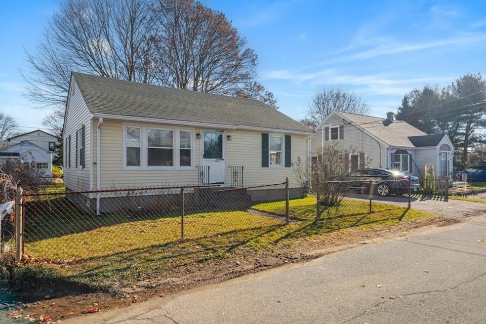

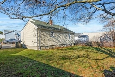

20 Sherbourne Ave Swansea, MA 02777
Ocean Grove NeighborhoodEstimated payment $2,198/month
Highlights
- Property is near public transit
- Wood Flooring
- Shops
- Ranch Style House
- No HOA
- Central Heating
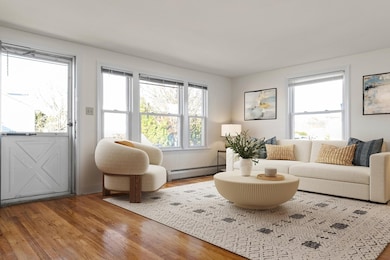
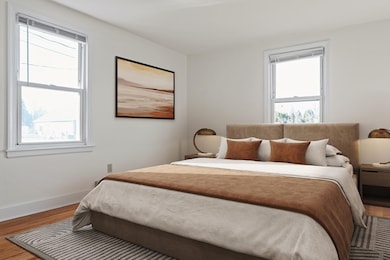
About This Home
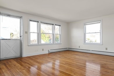
Great 2-bedroom starter or retirement home that has been totally refreshed, new countertops, refaced cabinet doors, new kitchen, bath and hall floors, hardwood floors in living room and bedrooms. Tilt out vinyl windows, newer gas heat, and hot water tank, full basement with washer and dryer hook up. Close to Swansea Town beach and boat ramp and great access to downtown Warren, Bristol and to major highways. Photos have been virtually staged.OPEN HOUSE SATURDAY DECEMBER 6TH 11:30 TO 1 PM
Open House Schedule
-
Saturday, December 06, 202511:30 am to 1:00 pm12/6/2025 11:30:00 AM +00:0012/6/2025 1:00:00 PM +00:00Add to Calendar
Home Details
Home Type
- Single Family
Est. Annual Taxes
- $3,636
Year Built
- Built in 1948
Lot Details
- 4,356 Sq Ft Lot
- Level Lot
Home Design
- 780 Sq Ft Home
- Ranch Style House
- Frame Construction
- Shingle Roof
- Concrete Perimeter Foundation
Flooring
- Wood
- Laminate
Bedrooms and Bathrooms
- 2 Bedrooms
- 1 Full Bathroom
Basement
- Basement Fills Entire Space Under The House
- Laundry in Basement
Parking
- 2 Car Parking Spaces
- Driveway
- Open Parking
- Off-Street Parking
Utilities
- No Cooling
- Central Heating
- 1 Heating Zone
- Baseboard Heating
- Gas Water Heater
- Private Sewer
Additional Features
- Range
- Property is near public transit
Listing and Financial Details
- Tax Lot 52
- Assessor Parcel Number 3611192
Community Details
Overview
- No Home Owners Association
- Wibur Subdivision
Amenities
- Shops
Map
Home Values in the Area
Average Home Value in this Area
Tax History
| Year | Tax Paid | Tax Assessment Tax Assessment Total Assessment is a certain percentage of the fair market value that is determined by local assessors to be the total taxable value of land and additions on the property. | Land | Improvement |
|---|---|---|---|---|
| 2025 | $3,636 | $305,000 | $140,000 | $165,000 |
| 2024 | $3,621 | $302,000 | $140,000 | $162,000 |
| 2023 | $3,464 | $263,800 | $104,300 | $159,500 |
| 2022 | $3,366 | $233,900 | $90,700 | $143,200 |
| 2021 | $3,124 | $199,900 | $90,300 | $109,600 |
| 2020 | $3,175 | $203,800 | $94,200 | $109,600 |
| 2019 | $2,958 | $190,700 | $81,100 | $109,600 |
| 2018 | $2,747 | $179,800 | $75,000 | $104,800 |
| 2017 | $2,344 | $176,500 | $71,700 | $104,800 |
| 2016 | $2,400 | $177,500 | $69,300 | $108,200 |
| 2015 | $2,186 | $166,500 | $69,300 | $97,200 |
| 2014 | $2,155 | $167,800 | $69,300 | $98,500 |
Property History
| Date | Event | Price | List to Sale | Price per Sq Ft |
|---|---|---|---|---|
| 12/01/2025 12/01/25 | For Sale | $359,900 | -- | $461 / Sq Ft |
Purchase History
| Date | Type | Sale Price | Title Company |
|---|---|---|---|
| Quit Claim Deed | -- | -- | |
| Deed | $95,000 | -- |
Mortgage History
| Date | Status | Loan Amount | Loan Type |
|---|---|---|---|
| Open | $245,000 | New Conventional | |
| Previous Owner | $231,500 | Purchase Money Mortgage |
Source: MLS Property Information Network (MLS PIN)
MLS Number: 73458414
APN: SWAN-000520-000052
Disclaimer: Certain information contained herein is derived from information provided by parties other than Homes.com. All information provided is deemed reliable, but is not guaranteed to be accurate and should be independently verified.
![]() The property listing data and information, or the Images, set forth herein were provided to MLS Property Information Network, Inc. from third party sources, including sellers, lessors and public records, and were compiled by MLS Property Information Network, Inc. The property listing data and information, and the Images, are for the personal, non-commercial use of consumers having a good faith interest in purchasing or leasing listed properties of the type displayed to them and may not be used for any purpose other than to identify prospective properties which such consumers may have a good faith interest in purchasing or leasing. MLS Property Information Network, Inc. and its subscribers disclaim any and all representations and warranties as to the accuracy of the property listing data and information, or as to the accuracy of any of the Images, set forth herein.
The property listing data and information, or the Images, set forth herein were provided to MLS Property Information Network, Inc. from third party sources, including sellers, lessors and public records, and were compiled by MLS Property Information Network, Inc. The property listing data and information, and the Images, are for the personal, non-commercial use of consumers having a good faith interest in purchasing or leasing listed properties of the type displayed to them and may not be used for any purpose other than to identify prospective properties which such consumers may have a good faith interest in purchasing or leasing. MLS Property Information Network, Inc. and its subscribers disclaim any and all representations and warranties as to the accuracy of the property listing data and information, or as to the accuracy of any of the Images, set forth herein.
- 229 Oneil Rd Unit 1
- 508 Grand Army of the Republic Highway St
- 76 Houlton St Unit 1
- 297 Swansom Rd
- 43 Serpentine Rd
- 1212 Riverside Ave Unit Furnished 2 Bed
- 1082 Davol St
- 700 Metacom Ave
- 624 Metacom Ave
- 117 Howard St Unit 1
- 112 Short St Unit 2 WEST
- 101 Cory St Unit 3
- 89 Globe Mills Ave
- 32 Oregon St Unit 32 Oregon st
- 32 Norfolk St Unit 1 E
- 229 Brightman St
- 229 Brightman St Unit 2
- 88 Almy St Unit 1a
- 24 Ash St Unit 3
- 91 Columbia St Unit 1
