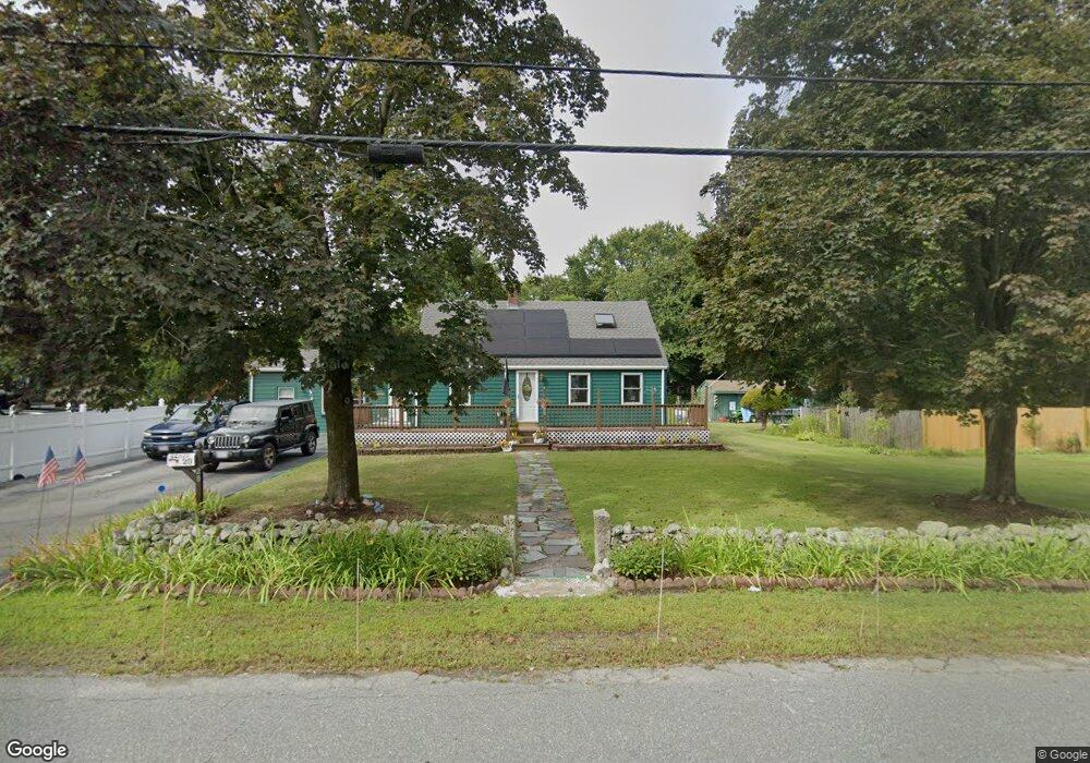
20 Spruce St Abington, MA 02351
Estimated Value: $525,000 - $721,000
3
Beds
2
Baths
1,899
Sq Ft
$320/Sq Ft
Est. Value
About This Home
This home is located at 20 Spruce St, Abington, MA 02351 and is currently estimated at $607,145, approximately $319 per square foot. 20 Spruce St is a home located in Plymouth County with nearby schools including Beaver Brook Elementary School, Abington Middle School, and Woodsdale School.
Ownership History
Date
Name
Owned For
Owner Type
Purchase Details
Closed on
Mar 12, 2019
Sold by
Lemos James L
Bought by
Lemos James L and Conant Melynda M
Current Estimated Value
Purchase Details
Closed on
Jun 11, 1993
Sold by
Mackiewicz Susan
Bought by
Lemos James L and Lemos Linda I
Home Financials for this Owner
Home Financials are based on the most recent Mortgage that was taken out on this home.
Original Mortgage
$131,100
Interest Rate
7.41%
Mortgage Type
Purchase Money Mortgage
Create a Home Valuation Report for This Property
The Home Valuation Report is an in-depth analysis detailing your home's value as well as a comparison with similar homes in the area
Home Values in the Area
Average Home Value in this Area
Purchase History
| Date | Buyer | Sale Price | Title Company |
|---|---|---|---|
| Lemos James L | -- | -- | |
| Lemos James L | $138,000 | -- |
Source: Public Records
Mortgage History
| Date | Status | Borrower | Loan Amount |
|---|---|---|---|
| Previous Owner | Lemos James L | $155,000 | |
| Previous Owner | Lemos James L | $131,100 |
Source: Public Records
Tax History
| Year | Tax Paid | Tax Assessment Tax Assessment Total Assessment is a certain percentage of the fair market value that is determined by local assessors to be the total taxable value of land and additions on the property. | Land | Improvement |
|---|---|---|---|---|
| 2025 | $6,947 | $531,900 | $243,400 | $288,500 |
| 2024 | $6,956 | $519,900 | $221,700 | $298,200 |
| 2023 | $6,615 | $465,500 | $193,300 | $272,200 |
| 2022 | $6,764 | $444,400 | $169,700 | $274,700 |
| 2021 | $9,504 | $371,800 | $154,300 | $217,500 |
| 2020 | $6,236 | $366,800 | $149,700 | $217,100 |
| 2019 | $5,928 | $340,900 | $142,800 | $198,100 |
| 2018 | $5,920 | $332,200 | $142,800 | $189,400 |
| 2017 | $3,092 | $296,900 | $142,800 | $154,100 |
| 2016 | $5,047 | $281,500 | $136,200 | $145,300 |
| 2015 | $4,665 | $274,400 | $136,200 | $138,200 |
Source: Public Records
Map
Nearby Homes
- 338 Adams St
- 73 Monroe St
- 56 Townsend St Unit D26
- 120 Glen St
- 1353 Washington St
- 0 Bedford St
- 1077 Bedford St
- 120 Temple St
- 590 Adams St
- 46 Carey St
- 17 Birch St Unit 135
- 40 Fir Rd Unit 386
- 9 Chestnut Cir
- 11 Chestnut Cir
- 6 Chestnut Cir
- 135 Grove St Unit 133
- 1 Canterbury Ln
- 103 Grove St Unit 349
- 103 Grove St Unit 317
- 0 W Water St
- 260 North Ave
- 260 North Ave Unit 3
- 23 Spruce St
- 23 Spruce St Unit 1
- 250 North Ave
- 240 North Ave
- 270 North Ave
- 29 Spruce St
- 288 North Ave
- 41 Spruce St
- 45 Spruce St
- 296 North Ave
- 296 North Ave Unit 1
- 296 North Ave Unit 2
- 285 North Ave
- 287 North Ave
- 287 North Ave Unit 287
- 285 North Ave Unit 285
- 245 North Ave
- 289 North Ave
Your Personal Tour Guide
Ask me questions while you tour the home.