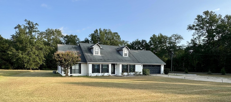
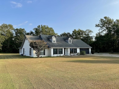


20 Stokes Rd Columbus, MS 39702
Estimated payment $2,200/month
Total Views
6,524
6
Beds
3
Baths
3,847
Sq Ft
$94
Price per Sq Ft
Highlights
- Traditional Architecture
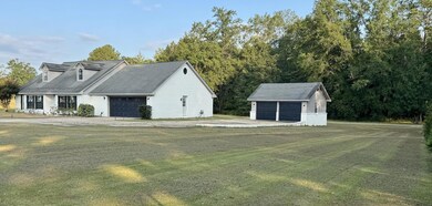
- Garage
- Central Heating and Cooling System
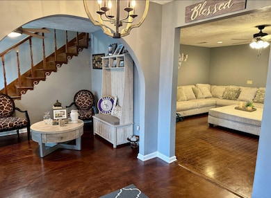
About This Home
Welcome to this expansive 6-bedroom, 3-bath home, perfectly nestled on an acre of land. Boasting over 3,000 square feet of living space, this property offers the perfect blend of city convenience and serene countryside vibes. Enjoy spacious living areas, a modern kitchen, and plenty of room for family and guests. With easy access to both city amenities and the tranquility of the county, this home is truly a rare find!
Home Details
Home Type
- Single Family
Est. Annual Taxes
- $3,338
Year Built
- Built in 2000
Lot Details
- 1 Acre Lot
Parking
- Garage
Home Design
- 3,847 Sq Ft Home
- Traditional Architecture
Kitchen
- Stove
- Dishwasher
Bedrooms and Bathrooms
- 6 Bedrooms
- 3 Full Bathrooms
Utilities
- Central Heating and Cooling System
- Electric Water Heater
Listing and Financial Details
- Assessor Parcel Number 69W00012613
Map
Create a Home Valuation Report for This Property
The Home Valuation Report is an in-depth analysis detailing your home's value as well as a comparison with similar homes in the area
Tax History
| Year | Tax Paid | Tax Assessment Tax Assessment Total Assessment is a certain percentage of the fair market value that is determined by local assessors to be the total taxable value of land and additions on the property. | Land | Improvement |
|---|---|---|---|---|
| 2025 | $3,383 | $22,546 | $0 | $0 |
| 2024 | $3,338 | $22,546 | $0 | $0 |
| 2023 | $2,890 | $19,505 | $0 | $0 |
| 2022 | $3,685 | $22,429 | $0 | $0 |
| 2021 | $0 | $14,952 | $0 | $0 |
| 2020 | $0 | $14,952 | $0 | $0 |
| 2019 | $0 | $14,856 | $0 | $0 |
| 2018 | $0 | $14,903 | $0 | $0 |
| 2017 | $0 | $14,903 | $0 | $0 |
| 2016 | $0 | $14,903 | $0 | $0 |
| 2015 | -- | $15,506 | $0 | $0 |
| 2014 | -- | $15,506 | $0 | $0 |
Source: Public Records
Property History
| Date | Event | Price | List to Sale | Price per Sq Ft |
|---|---|---|---|---|
| 12/08/2025 12/08/25 | Price Changed | $360,000 | -5.3% | $94 / Sq Ft |
| 11/03/2025 11/03/25 | Price Changed | $380,000 | -2.6% | $99 / Sq Ft |
| 10/26/2025 10/26/25 | For Sale | $390,000 | -- | $101 / Sq Ft |
Source: Golden Triangle Association of REALTORS®
Purchase History
| Date | Type | Sale Price | Title Company |
|---|---|---|---|
| Warranty Deed | -- | None Listed On Document | |
| Quit Claim Deed | -- | -- | |
| Quit Claim Deed | -- | -- |
Source: Public Records
Mortgage History
| Date | Status | Loan Amount | Loan Type |
|---|---|---|---|
| Open | $260,200 | FHA |
Source: Public Records
Source: Golden Triangle Association of REALTORS®
MLS Number: 25-2207
APN: 69W22-00-23100
Nearby Homes
- 0 Nashville Ferry Rd E
- 0 S Pickensville Rd
- 394 Pickensville Rd
- 0 Yorkville Rd E
- 279 Pandora Dr
- 3106 Mississippi 69
- 125 Robinwood Cir
- 215 Robinwood Cir
- 307 Vance St
- 1076 S Pickensville Rd
- 201 Mccrary Dr
- 210 Airline Rd
- 630 22nd St S
- 405 Springdale Dr
- 119 King St
- 60 1st Colony Dr
- 102 S Browder St
- 9 Monticello Cir
- 0 Highway 182 E
- 59 Savannah St
- 41 Kaye Dr
- 306 Mccrary Dr
- 1101-1105 11th Ave S
- 137 Poplar St
- 220 20th St N
- 3946 Hwy 182 E
- 302 S 11th St Unit 8
- 706 Cypress St
- 626 Waterworks Rd Unit 1
- 720 3rd Ave S
- 412 6th St S
- 412 6th St S
- 622 4th St S Unit C
- 805 Spruce St
- 310 12th St N
- 320 11th St N Unit 2
- 515 College St Unit E
- 427 College St Unit 4
- 501 Brooks Rd
- 423 Main St Unit 423

Your Personal Tour Guide
Ask me questions while you tour the home.