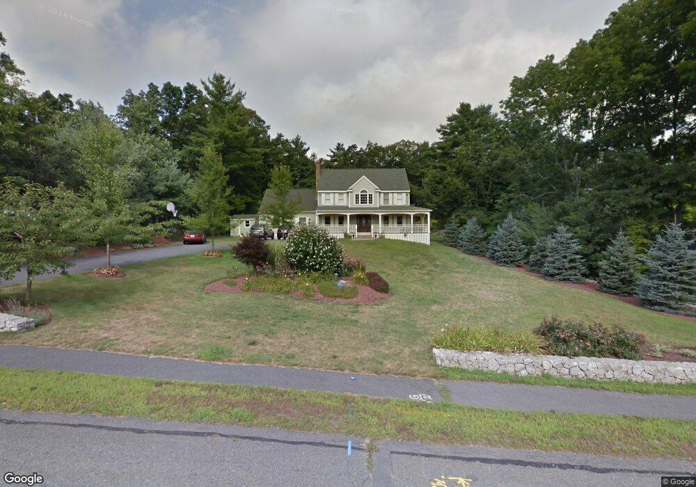
20 Tilting Rock Rd Wrentham, MA 02093
Estimated Value: $824,000 - $1,099,000
4
Beds
3
Baths
1,911
Sq Ft
$501/Sq Ft
Est. Value
About This Home
This home is located at 20 Tilting Rock Rd, Wrentham, MA 02093 and is currently estimated at $957,170, approximately $500 per square foot. 20 Tilting Rock Rd is a home located in Norfolk County with nearby schools including Delaney Elementary School, Charles E Roderick, and The Sage School.
Ownership History
Date
Name
Owned For
Owner Type
Purchase Details
Closed on
Jun 27, 2003
Sold by
Ford Michael T and Ford Linda J
Bought by
Ringler David J and Ringler Cheryl A
Current Estimated Value
Purchase Details
Closed on
Sep 30, 1994
Sold by
Lorusso Tr Gerard C
Bought by
Ford Michael T and Ford Linda J
Create a Home Valuation Report for This Property
The Home Valuation Report is an in-depth analysis detailing your home's value as well as a comparison with similar homes in the area
Home Values in the Area
Average Home Value in this Area
Purchase History
| Date | Buyer | Sale Price | Title Company |
|---|---|---|---|
| Ringler David J | $425,000 | -- | |
| Ford Michael T | $219,900 | -- |
Source: Public Records
Mortgage History
| Date | Status | Borrower | Loan Amount |
|---|---|---|---|
| Open | Ford Michael T | $371,000 | |
| Closed | Ford Michael T | $251,000 | |
| Closed | Ford Michael T | $125,000 |
Source: Public Records
Tax History Compared to Growth
Tax History
| Year | Tax Paid | Tax Assessment Tax Assessment Total Assessment is a certain percentage of the fair market value that is determined by local assessors to be the total taxable value of land and additions on the property. | Land | Improvement |
|---|---|---|---|---|
| 2025 | $9,397 | $810,800 | $306,200 | $504,600 |
| 2024 | $8,972 | $747,700 | $306,200 | $441,500 |
| 2023 | $8,951 | $709,300 | $278,600 | $430,700 |
| 2022 | $8,518 | $623,100 | $260,100 | $363,000 |
| 2021 | $7,685 | $546,200 | $227,500 | $318,700 |
| 2020 | $7,942 | $557,300 | $202,700 | $354,600 |
| 2019 | $7,873 | $557,600 | $219,300 | $338,300 |
| 2018 | $7,687 | $539,800 | $219,500 | $320,300 |
| 2017 | $7,481 | $525,000 | $215,300 | $309,700 |
| 2016 | $7,323 | $512,800 | $209,000 | $303,800 |
| 2015 | $7,124 | $475,600 | $185,800 | $289,800 |
| 2014 | $6,957 | $454,400 | $178,700 | $275,700 |
Source: Public Records
Map
Nearby Homes
- 10 Nature View Dr
- 15 Nature View Dr
- 362 East St
- 319 Taunton St
- 1 Lorraine Metcalf Dr
- 270 Dedham St
- 131 Creek St Unit 7
- 11 Earle Stewart Ln
- Lot 3 - 14 Earle Stewart Ln
- Lot 1 - Blueberry 2 Car Plan at King Philip Estates
- Lot 8 - Blueberry 2 Car Plan at King Philip Estates
- Lot 5 - Hughes 2 car Plan at King Philip Estates
- Lot 6 - Blueberry 3 Car Plan at King Philip Estates
- Lot 2 - Camden 2 Car Plan at King Philip Estates
- Lot 7 - Cedar Plan at King Philip Estates
- Lot 4 - Hemingway 2 Car Plan at King Philip Estates
- Lot 3 - Blueberry 2 Car Plan at King Philip Estates
- 65 Pond St
- 120 Hawes St
- 570 Franklin St
- 30 Tilting Rock Rd
- 134 East St
- 40 Tilting Rock Rd
- 25 Tilting Rock Rd
- 15 Tilting Rock Rd
- 160 East St
- 35 Tilting Rock Rd
- 50 Tilting Rock Rd
- 122 East St
- 146 East St
- 45 Tilting Rock Rd
- 130 East St
- 128 East St
- 128 East St Unit B
- 128 East St Unit 1
- 150 East St
- 70 Tilting Rock Rd
- 174 East St
- 145 East St
- 1 Lot St E