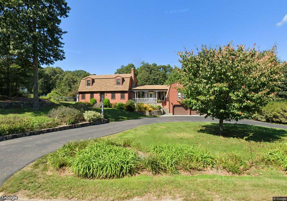
20 Warner Trail Rd Wrentham, MA 02093
Estimated Value: $726,000 - $853,000
3
Beds
2
Baths
2,883
Sq Ft
$282/Sq Ft
Est. Value
About This Home
This home is located at 20 Warner Trail Rd, Wrentham, MA 02093 and is currently estimated at $811,997, approximately $281 per square foot. 20 Warner Trail Rd is a home located in Norfolk County with nearby schools including Delaney Elementary School, Charles E Roderick, and The Sage School.
Ownership History
Date
Name
Owned For
Owner Type
Purchase Details
Closed on
Dec 20, 2024
Sold by
Warner Trail Rt and Murzycki
Bought by
Murzycki Joint Ret and Murzycki
Current Estimated Value
Purchase Details
Closed on
Jun 28, 2011
Sold by
Murzycki John V and Murzycki Carol A
Bought by
Warner Trail Rt and Murzycki John V
Purchase Details
Closed on
Oct 21, 1982
Bought by
Warner Trail Rt
Create a Home Valuation Report for This Property
The Home Valuation Report is an in-depth analysis detailing your home's value as well as a comparison with similar homes in the area
Home Values in the Area
Average Home Value in this Area
Purchase History
| Date | Buyer | Sale Price | Title Company |
|---|---|---|---|
| Murzycki Joint Ret | -- | None Available | |
| Murzycki Joint Ret | -- | None Available | |
| Warner Trail Rt | -- | -- | |
| Warner Trail Rt | -- | -- | |
| Warner Trail Rt | -- | -- |
Source: Public Records
Mortgage History
| Date | Status | Borrower | Loan Amount |
|---|---|---|---|
| Previous Owner | Warner Trail Rt | $50,000 | |
| Previous Owner | Warner Trail Rt | $44,000 |
Source: Public Records
Tax History Compared to Growth
Tax History
| Year | Tax Paid | Tax Assessment Tax Assessment Total Assessment is a certain percentage of the fair market value that is determined by local assessors to be the total taxable value of land and additions on the property. | Land | Improvement |
|---|---|---|---|---|
| 2025 | $8,045 | $694,100 | $273,200 | $420,900 |
| 2024 | $7,786 | $648,800 | $273,200 | $375,600 |
| 2023 | $8,047 | $637,600 | $248,300 | $389,300 |
| 2022 | $7,624 | $557,700 | $223,400 | $334,300 |
| 2021 | $7,435 | $528,400 | $199,600 | $328,800 |
| 2020 | $7,501 | $526,400 | $182,100 | $344,300 |
| 2019 | $7,433 | $526,400 | $182,100 | $344,300 |
| 2018 | $7,144 | $501,700 | $182,300 | $319,400 |
| 2017 | $6,953 | $487,900 | $178,800 | $309,100 |
| 2016 | $6,632 | $464,400 | $173,600 | $290,800 |
| 2015 | $6,650 | $443,900 | $166,900 | $277,000 |
| 2014 | $6,690 | $437,000 | $160,500 | $276,500 |
Source: Public Records
Map
Nearby Homes
- 362 East St
- 120 Hawes St
- 65 Pond St
- 483 Thurston St
- 319 Taunton St
- 1 Lorraine Metcalf Dr
- 10 Nature View Dr
- 15 Nature View Dr
- 270 Dedham St
- 11 Earle Stewart Ln
- 131 Creek St Unit 7
- Lot 1 - Blueberry 2 Car Plan at King Philip Estates
- Lot 8 - Blueberry 2 Car Plan at King Philip Estates
- Lot 5 - Hughes 2 car Plan at King Philip Estates
- Lot 6 - Blueberry 3 Car Plan at King Philip Estates
- Lot 2 - Camden 2 Car Plan at King Philip Estates
- Lot 7 - Cedar Plan at King Philip Estates
- Lot 4 - Hemingway 2 Car Plan at King Philip Estates
- Lot 3 - Blueberry 2 Car Plan at King Philip Estates
- Lot 3 - 14 Earle Stewart Ln
- 10 Warner Trail Rd
- 15 Warner Trail Rd
- 30 Warner Trail Rd
- 5 Warner Trail Rd
- 25 Warner Trail Rd
- 198 Thurston St
- 35 Warner Trail Rd
- 184 Thurston St
- 20 Lherault Dr
- 10 Lot 10 L'Herault Dr
- 10 Lherault Dr
- 10 L'Herault Dr
- 30 Lherault Dr
- 210 Thurston St
- 260 Cowell Rd
- 310 Cowell Rd
- 270 Cowell Rd
- 280 Cowell Rd
- 290 Cowell Rd
- 270 Cowell Rd Unit 270