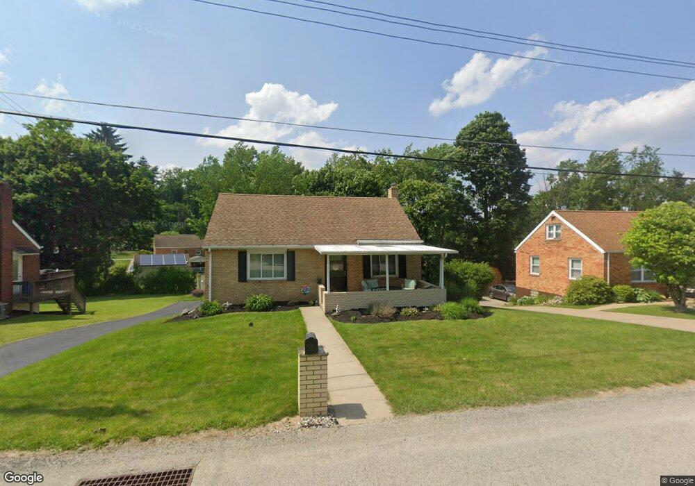
200 Andrew Dr Glenshaw, PA 15116
Shaler Township NeighborhoodEstimated Value: $254,528 - $290,000
4
Beds
2
Baths
1,238
Sq Ft
$217/Sq Ft
Est. Value
About This Home
This home is located at 200 Andrew Dr, Glenshaw, PA 15116 and is currently estimated at $268,382, approximately $216 per square foot. 200 Andrew Dr is a home located in Allegheny County with nearby schools including Shaler Area Elementary School, Scott Primary School, and Shaler Area Middle School.
Ownership History
Date
Name
Owned For
Owner Type
Purchase Details
Closed on
Jul 13, 2009
Sold by
Barrett Douglas J
Bought by
Balsomico Jason A
Current Estimated Value
Home Financials for this Owner
Home Financials are based on the most recent Mortgage that was taken out on this home.
Original Mortgage
$132,554
Outstanding Balance
$87,039
Interest Rate
5.43%
Mortgage Type
FHA
Estimated Equity
$181,343
Purchase Details
Closed on
Mar 5, 2004
Sold by
Sullivan Daniel
Bought by
Barrett Douglas
Home Financials for this Owner
Home Financials are based on the most recent Mortgage that was taken out on this home.
Original Mortgage
$100,000
Interest Rate
5.62%
Mortgage Type
New Conventional
Purchase Details
Closed on
Nov 28, 1997
Sold by
Secen Albert V and Secen Carol A
Bought by
Sullivan Daniel J and Sullivan Susan V
Create a Home Valuation Report for This Property
The Home Valuation Report is an in-depth analysis detailing your home's value as well as a comparison with similar homes in the area
Home Values in the Area
Average Home Value in this Area
Purchase History
| Date | Buyer | Sale Price | Title Company |
|---|---|---|---|
| Balsomico Jason A | $135,000 | -- | |
| Barrett Douglas | $125,000 | -- | |
| Sullivan Daniel J | $99,900 | -- |
Source: Public Records
Mortgage History
| Date | Status | Borrower | Loan Amount |
|---|---|---|---|
| Open | Balsomico Jason A | $132,554 | |
| Previous Owner | Barrett Douglas | $100,000 |
Source: Public Records
Tax History Compared to Growth
Tax History
| Year | Tax Paid | Tax Assessment Tax Assessment Total Assessment is a certain percentage of the fair market value that is determined by local assessors to be the total taxable value of land and additions on the property. | Land | Improvement |
|---|---|---|---|---|
| 2025 | $3,856 | $117,100 | $39,600 | $77,500 |
| 2024 | $3,856 | $117,100 | $39,600 | $77,500 |
| 2023 | $3,718 | $117,100 | $39,600 | $77,500 |
| 2022 | $3,718 | $117,100 | $39,600 | $77,500 |
| 2021 | $554 | $117,100 | $39,600 | $77,500 |
| 2020 | $3,718 | $117,100 | $39,600 | $77,500 |
| 2019 | $3,601 | $117,100 | $39,600 | $77,500 |
| 2018 | $554 | $117,100 | $39,600 | $77,500 |
| 2017 | $3,487 | $117,100 | $39,600 | $77,500 |
| 2016 | $554 | $117,100 | $39,600 | $77,500 |
| 2015 | $554 | $117,100 | $39,600 | $77,500 |
| 2014 | $3,344 | $117,100 | $39,600 | $77,500 |
Source: Public Records
Map
Nearby Homes
- 208 Andrew Dr
- 308 Sandy Dr
- 113 Mcginley Dr
- 620 Northaven Cir
- 447 Englewood Dr
- 140 Hodil Rd
- 102 Forliview Rd
- 105 Forliview Rd
- 101 Sunset Dr
- 133 Sunset Ln
- 103 Hodil Rd
- 530 Glenhaven Dr
- 155 Cherrington Dr
- 2501 Oakwood Rd
- 2609 Autumnwood Dr
- 356 Goldsmith Rd
- 404 McElheny Rd
- 104 Sunnyhill Dr
- 2603 Sherwood Rd
- 2307 Mount Royal Blvd