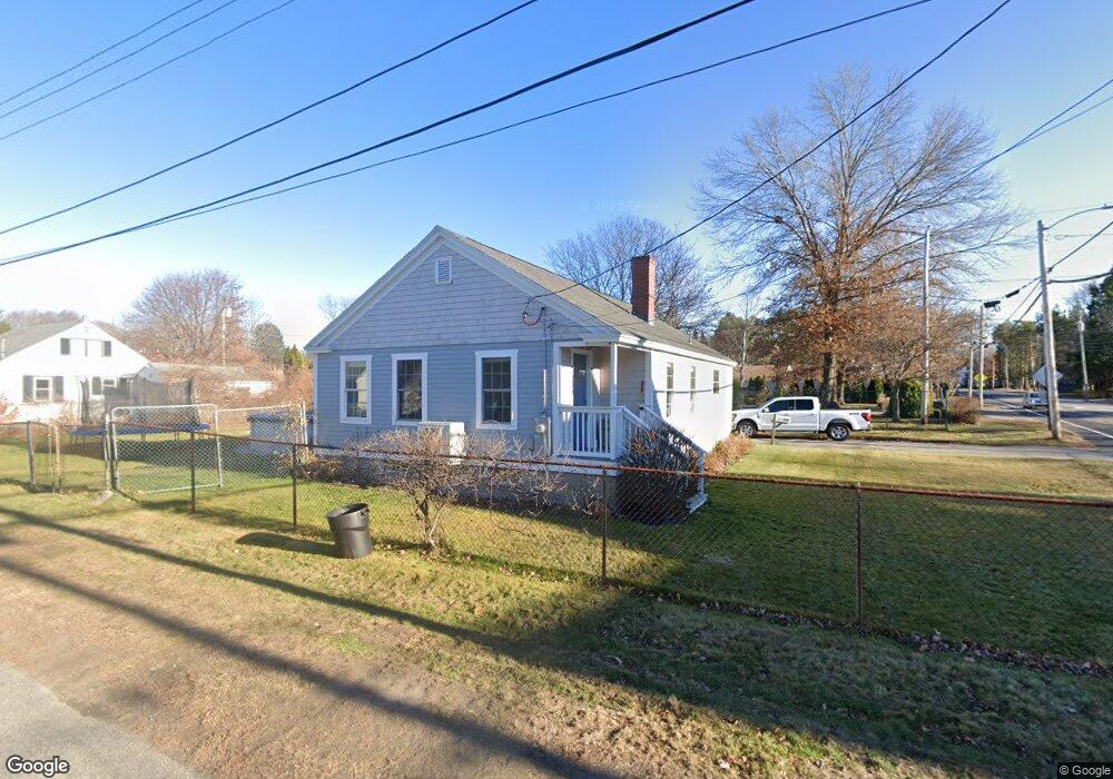
200 Beach St Saco, ME 04072
Central Saco NeighborhoodEstimated Value: $338,000 - $393,000
2
Beds
1
Bath
986
Sq Ft
$370/Sq Ft
Est. Value
About This Home
This home is located at 200 Beach St, Saco, ME 04072 and is currently estimated at $365,086, approximately $370 per square foot. 200 Beach St is a home located in York County with nearby schools including C K Burns School, Saco Middle School, and Saint James School.
Ownership History
Date
Name
Owned For
Owner Type
Purchase Details
Closed on
Jul 1, 2021
Sold by
Sherman John W and Sherman Katina
Bought by
Pembroke Management Llc
Current Estimated Value
Home Financials for this Owner
Home Financials are based on the most recent Mortgage that was taken out on this home.
Original Mortgage
$2,056,875
Outstanding Balance
$1,841,841
Interest Rate
2.9%
Mortgage Type
Purchase Money Mortgage
Estimated Equity
-$1,476,755
Purchase Details
Closed on
Oct 19, 2016
Sold by
Descoteaux Richard W and Descoteaux Lucienne C
Bought by
Nostrom Lori A and Nostrom Andrew
Create a Home Valuation Report for This Property
The Home Valuation Report is an in-depth analysis detailing your home's value as well as a comparison with similar homes in the area
Home Values in the Area
Average Home Value in this Area
Purchase History
| Date | Buyer | Sale Price | Title Company |
|---|---|---|---|
| Pembroke Management Llc | -- | None Available | |
| Nostrom Lori A | -- | -- |
Source: Public Records
Mortgage History
| Date | Status | Borrower | Loan Amount |
|---|---|---|---|
| Open | Pembroke Management Llc | $2,056,875 |
Source: Public Records
Tax History
| Year | Tax Paid | Tax Assessment Tax Assessment Total Assessment is a certain percentage of the fair market value that is determined by local assessors to be the total taxable value of land and additions on the property. | Land | Improvement |
|---|---|---|---|---|
| 2024 | $3,423 | $243,600 | $118,200 | $125,400 |
| 2023 | $3,593 | $243,600 | $118,200 | $125,400 |
| 2022 | $3,255 | $177,600 | $90,200 | $87,400 |
| 2021 | $3,100 | $164,200 | $80,600 | $83,600 |
| 2020 | $2,907 | $147,800 | $70,800 | $77,000 |
| 2019 | $2,864 | $147,800 | $70,800 | $77,000 |
| 2018 | $2,847 | $141,400 | $64,400 | $77,000 |
| 2017 | $2,721 | $140,400 | $64,400 | $76,000 |
| 2016 | $2,847 | $146,600 | $59,900 | $86,700 |
| 2015 | $2,797 | $145,500 | $59,900 | $85,600 |
| 2014 | $2,709 | $145,500 | $59,900 | $85,600 |
| 2013 | $2,703 | $145,500 | $59,900 | $85,600 |
Source: Public Records
Map
Nearby Homes
- 16 Heritage Way Unit 17
- 20 Heritage Way Unit 15
- 8 Heritage Way Unit 21
- 25 Heritage Way Unit 11
- 8 Park Ave
- 8 Horseshoe Dr Unit 8
- 16 Bartlett St
- 2 Breakwater Way Unit 2
- 4 Mainsail Ln Unit 4
- 38 Pine Ridge Rd
- 79 Ferry Rd
- 18 Free St
- 18 Coolidge Ave
- 6 Middle St
- 13 Lucille St
- 26 Vernon St
- 11 Peabody Ln Unit 101
- 170 Cleaves St
- 50 Ocean Park Rd Unit 101
- 147 Cleaves St Unit 3
Your Personal Tour Guide
Ask me questions while you tour the home.