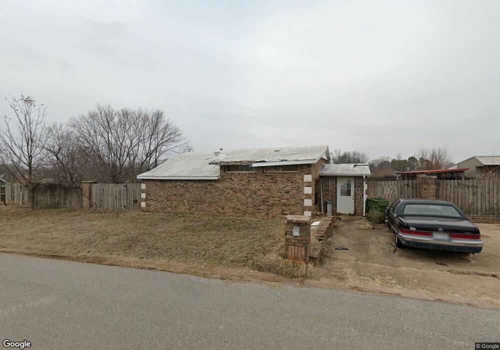
200 Buttry Rd Rogers, AR 72756
Estimated Value: $212,000 - $317,000
3
Beds
2
Baths
1,300
Sq Ft
$210/Sq Ft
Est. Value
About This Home
This home is located at 200 Buttry Rd, Rogers, AR 72756 and is currently estimated at $272,998, approximately $209 per square foot. 200 Buttry Rd is a home located in Benton County with nearby schools including Northside Elementary School, Lingle Middle School, and Rogers Heritage High School.
Ownership History
Date
Name
Owned For
Owner Type
Purchase Details
Closed on
May 9, 2023
Sold by
Carl W Evans Revocable Trust
Bought by
Evans Charli H
Current Estimated Value
Purchase Details
Closed on
Sep 17, 1998
Bought by
Evans and Harris
Purchase Details
Closed on
Jul 28, 1997
Bought by
Shook and Shook 02Ac
Purchase Details
Closed on
Oct 12, 1995
Bought by
Dod 10-12-1995
Purchase Details
Closed on
Jan 18, 1994
Bought by
Shook and Shook 22Ac
Purchase Details
Closed on
Oct 28, 1991
Bought by
Waggonner
Purchase Details
Closed on
Aug 16, 1991
Bought by
Slaggoner
Purchase Details
Closed on
Mar 5, 1991
Bought by
Shook and Shook 22Ac
Create a Home Valuation Report for This Property
The Home Valuation Report is an in-depth analysis detailing your home's value as well as a comparison with similar homes in the area
Home Values in the Area
Average Home Value in this Area
Purchase History
| Date | Buyer | Sale Price | Title Company |
|---|---|---|---|
| Evans Charli H | -- | None Listed On Document | |
| Evans | -- | -- | |
| Shook | -- | -- | |
| Dod 10-12-1995 | -- | -- | |
| Shook | $25,000 | -- | |
| Waggonner | -- | -- | |
| Slaggoner | $170,000 | -- | |
| Shook | -- | -- |
Source: Public Records
Tax History
| Year | Tax Paid | Tax Assessment Tax Assessment Total Assessment is a certain percentage of the fair market value that is determined by local assessors to be the total taxable value of land and additions on the property. | Land | Improvement |
|---|---|---|---|---|
| 2025 | $1,051 | $42,890 | $8,000 | $34,890 |
| 2024 | $979 | $42,890 | $8,000 | $34,890 |
| 2023 | $932 | $27,200 | $4,400 | $22,800 |
| 2022 | $552 | $27,200 | $4,400 | $22,800 |
| 2021 | $507 | $27,200 | $4,400 | $22,800 |
| 2020 | $466 | $18,930 | $4,000 | $14,930 |
| 2019 | $432 | $18,930 | $4,000 | $14,930 |
| 2018 | $424 | $18,930 | $4,000 | $14,930 |
| 2017 | $318 | $18,930 | $4,000 | $14,930 |
| 2016 | $318 | $18,930 | $4,000 | $14,930 |
| 2015 | $649 | $12,260 | $3,000 | $9,260 |
| 2014 | $299 | $12,260 | $3,000 | $9,260 |
Source: Public Records
Map
Nearby Homes
- 200 W Kimberly Ln
- 4920 Kreeger Rd
- 4200 Hilltop Dr
- 4112 Hilltop Dr
- 5116 Joe Ln
- 12412 Wildwood Dr
- 12418 Wildwood Dr
- 12424 Wildwood Dr
- 0 Clover Ln Unit 1339285
- 11680 Amy Ave
- 12437 Wildwood Dr
- Tracts A/B N 94 Hwy
- 1109 Little Flock Dr
- 12620 Lindy Ln
- 5201 Highway 94 N
- 4105 Rolling Meadows Dr
- 4110 Rolling Meadows Dr
- 4008 Rolling Meadows Dr
- 4001 Rolling Meadows Dr
- 1325 Little Flock Dr
- 4700 N 2nd St
- 204 Buttry Rd
- 206 Buttry Rd
- 208 Buttry Rd
- 4705 N 2nd St
- 4703 N 2nd St
- 210 Buttry Rd
- 207 Buttry Rd
- 4800 N 2nd St
- 204 W Kimberly Ln
- 4709 N 2nd St
- 202 Kimberly Ln
- 204 Kimberly Ln
- 206 Kimberly Ln
- 208 Kimberly Ln
- 200 Kimberly Ln
- 414 Buttry Rd
- 205 Kimberly Ln
- 203 Kimberly Ln
- 201 W Kimberly Ln
Your Personal Tour Guide
Ask me questions while you tour the home.