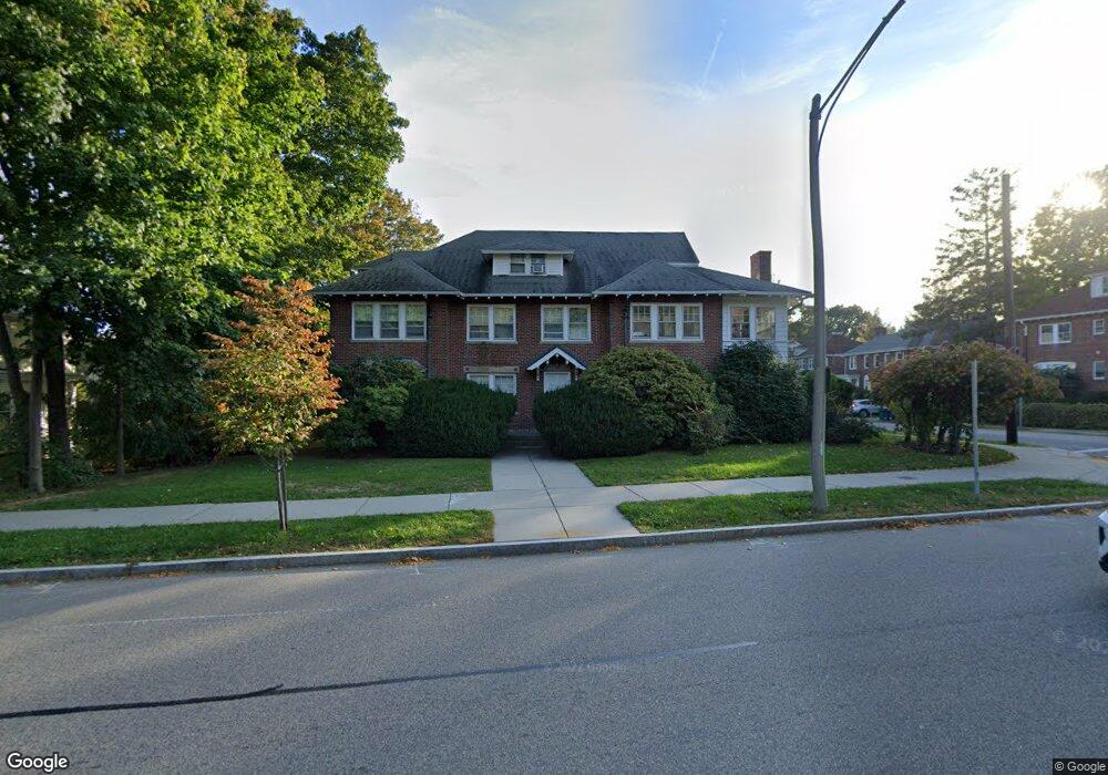
200 Commonwealth Ave Chestnut Hill, MA 02467
Chestnut Hill NeighborhoodEstimated Value: $2,223,000 - $3,044,000
5
Beds
2
Baths
1,500
Sq Ft
$1,749/Sq Ft
Est. Value
About This Home
This home is located at 200 Commonwealth Ave, Chestnut Hill, MA 02467 and is currently estimated at $2,622,881, approximately $1,748 per square foot. 200 Commonwealth Ave is a home located in Middlesex County with nearby schools including Ward Elementary School, Bigelow Middle School, and Newton North High School.
Ownership History
Date
Name
Owned For
Owner Type
Purchase Details
Closed on
Sep 16, 1991
Sold by
Berry Ida L and Rosen Charlotte
Bought by
Rosen Malcolm and Rosen Charlotte
Current Estimated Value
Home Financials for this Owner
Home Financials are based on the most recent Mortgage that was taken out on this home.
Original Mortgage
$116,000
Interest Rate
9.34%
Mortgage Type
Purchase Money Mortgage
Create a Home Valuation Report for This Property
The Home Valuation Report is an in-depth analysis detailing your home's value as well as a comparison with similar homes in the area
Home Values in the Area
Average Home Value in this Area
Purchase History
| Date | Buyer | Sale Price | Title Company |
|---|---|---|---|
| Rosen Malcolm | $100,000 | -- |
Source: Public Records
Mortgage History
| Date | Status | Borrower | Loan Amount |
|---|---|---|---|
| Open | 200 Comm Avenue Rt | $1,500,000 | |
| Closed | 200 Commonwealth Ave R | $485,000 | |
| Closed | Avenue 200 Masscommof | $200,000 | |
| Closed | Rosen Malcolm | $25,000 | |
| Closed | Rosen Malcolm | $116,000 |
Source: Public Records
Tax History Compared to Growth
Tax History
| Year | Tax Paid | Tax Assessment Tax Assessment Total Assessment is a certain percentage of the fair market value that is determined by local assessors to be the total taxable value of land and additions on the property. | Land | Improvement |
|---|---|---|---|---|
| 2025 | $19,001 | $1,938,900 | $1,145,100 | $793,800 |
| 2024 | $18,372 | $1,882,400 | $1,111,700 | $770,700 |
| 2023 | $17,993 | $1,767,500 | $905,300 | $862,200 |
| 2022 | $17,217 | $1,636,600 | $838,200 | $798,400 |
| 2021 | $15,349 | $1,426,500 | $769,000 | $657,500 |
| 2020 | $13,066 | $1,251,500 | $769,000 | $482,500 |
| 2019 | $12,222 | $1,169,600 | $718,700 | $450,900 |
| 2018 | $12,646 | $1,168,800 | $677,300 | $491,500 |
| 2017 | $11,924 | $1,072,300 | $621,400 | $450,900 |
| 2016 | $11,196 | $983,800 | $570,100 | $413,700 |
| 2015 | $10,674 | $919,400 | $532,800 | $386,600 |
Source: Public Records
Map
Nearby Homes
- 254 Commonwealth Ave
- 9 Woodman Rd
- 27-29 Commonwealth Ave Unit 5
- 35 Commonwealth Ave Unit 404
- 30 Edge Hill Rd
- 29 Undine Rd
- 85 Gate House Rd
- 116 Lake Shore Rd Unit 4
- 92 Grant Ave
- 9 The Ledges Rd
- 12 Valley Spring Rd
- 144 Kenrick St Unit 32
- 27 Suffolk Rd
- 211 Lake Shore Rd Unit 2
- 25-27 Westbourne Rd
- 12 Garner St
- 68 Kenrick St
- 77 Cotton St
- 21 Glenley Terrace
- 12 Mina Way
- 200 Commonwealth Ave Unit 1
- 200 Commonwealth Ave Unit uni1 5-bed 2.5-bath
- 200 Commonwealth Ave
- 200 Commonwealth Ave Unit 1A
- 200 Commonwealth Ave Unit 1
- 200 Commonwealth Ave Unit U
- 200 Commonwealth Ave Unit 3
- 10 Crosby Rd Unit 12
- 10 Crosby Rd Unit 2
- 194 Commonwealth Ave
- 214 Commonwealth Ave
- 214 Commonwealth Ave Unit A
- 214 Commonwealth Ave Unit 2
- 214 Commonwealth Ave
- 214 Commonwealth Ave Unit 1
- 20 Crosby Rd Unit 1
- 18 Crosby Rd Unit 20
- 18 Crosby Rd Unit 18
- 18 Crosby Rd Unit 1
- 188 Commonwealth Ave