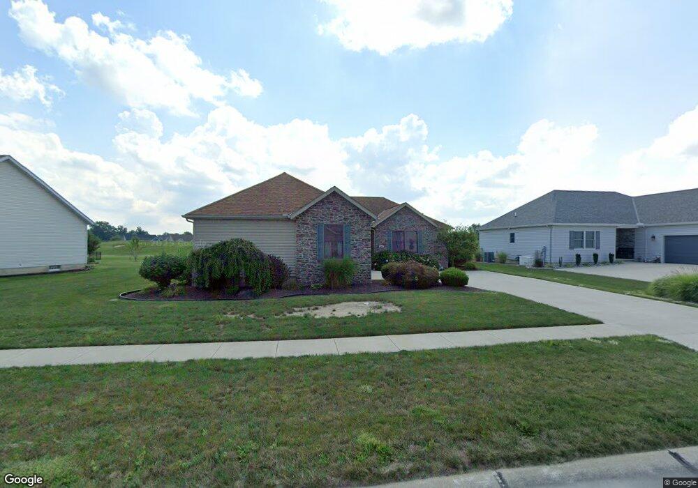
200 Granger Dr Lagrange, OH 44050
Estimated Value: $321,856 - $370,000
2
Beds
2
Baths
1,689
Sq Ft
$207/Sq Ft
Est. Value
About This Home
This home is located at 200 Granger Dr, Lagrange, OH 44050 and is currently estimated at $349,214, approximately $206 per square foot. 200 Granger Dr is a home located in Lorain County with nearby schools including Keystone Elementary School, Keystone Middle School, and Keystone High School.
Ownership History
Date
Name
Owned For
Owner Type
Purchase Details
Closed on
Sep 25, 2008
Sold by
Stiner & Sons Construction Inc
Bought by
Magalski Gary and Magalski Gary A
Current Estimated Value
Purchase Details
Closed on
Dec 18, 2003
Sold by
Durham Ridge Investments Llc
Bought by
Stiner & Sons Construction Inc
Home Financials for this Owner
Home Financials are based on the most recent Mortgage that was taken out on this home.
Original Mortgage
$325,000
Interest Rate
5.91%
Mortgage Type
Purchase Money Mortgage
Create a Home Valuation Report for This Property
The Home Valuation Report is an in-depth analysis detailing your home's value as well as a comparison with similar homes in the area
Home Values in the Area
Average Home Value in this Area
Purchase History
| Date | Buyer | Sale Price | Title Company |
|---|---|---|---|
| Magalski Gary | $65,000 | Truetitle Agency Inc | |
| Stiner & Sons Construction Inc | $325,000 | -- |
Source: Public Records
Mortgage History
| Date | Status | Borrower | Loan Amount |
|---|---|---|---|
| Closed | Stiner & Sons Construction Inc | $325,000 |
Source: Public Records
Tax History
| Year | Tax Paid | Tax Assessment Tax Assessment Total Assessment is a certain percentage of the fair market value that is determined by local assessors to be the total taxable value of land and additions on the property. | Land | Improvement |
|---|---|---|---|---|
| 2024 | $3,574 | $94,122 | $26,250 | $67,872 |
| 2023 | $2,917 | $66,651 | $17,217 | $49,434 |
| 2022 | $2,919 | $66,651 | $17,217 | $49,434 |
| 2021 | $2,920 | $66,651 | $17,217 | $49,434 |
| 2020 | $2,956 | $60,980 | $15,750 | $45,230 |
| 2019 | $2,939 | $60,980 | $15,750 | $45,230 |
| 2018 | $2,836 | $60,980 | $15,750 | $45,230 |
| 2017 | $2,945 | $59,520 | $12,300 | $47,220 |
| 2016 | $2,925 | $59,520 | $12,300 | $47,220 |
| 2015 | $2,922 | $59,520 | $12,300 | $47,220 |
| 2014 | $2,737 | $62,650 | $12,950 | $49,700 |
| 2013 | $2,655 | $62,650 | $12,950 | $49,700 |
Source: Public Records
Map
Nearby Homes
- 829 Robinson Dr
- 808 Buckingham Dr
- 800 Buckingham Dr
- 340 Granger Dr
- 801 Willich Ct
- 548 William St
- 567 Vicksburg Ct
- 516 Appomattox Ct
- 317 Church St
- 0 Dill Ct Unit 5072837
- 305 W Main St
- 110 Railroad St
- 40260 Whitney Rd
- 40175 Banks Rd
- 40163 Banks Rd
- 1033 Parsons Rd Unit 11
- 697 Main St
- 551 N Main St
- 42113 Meadow Ln
- 13301 Indian Hollow Rd
Your Personal Tour Guide
Ask me questions while you tour the home.