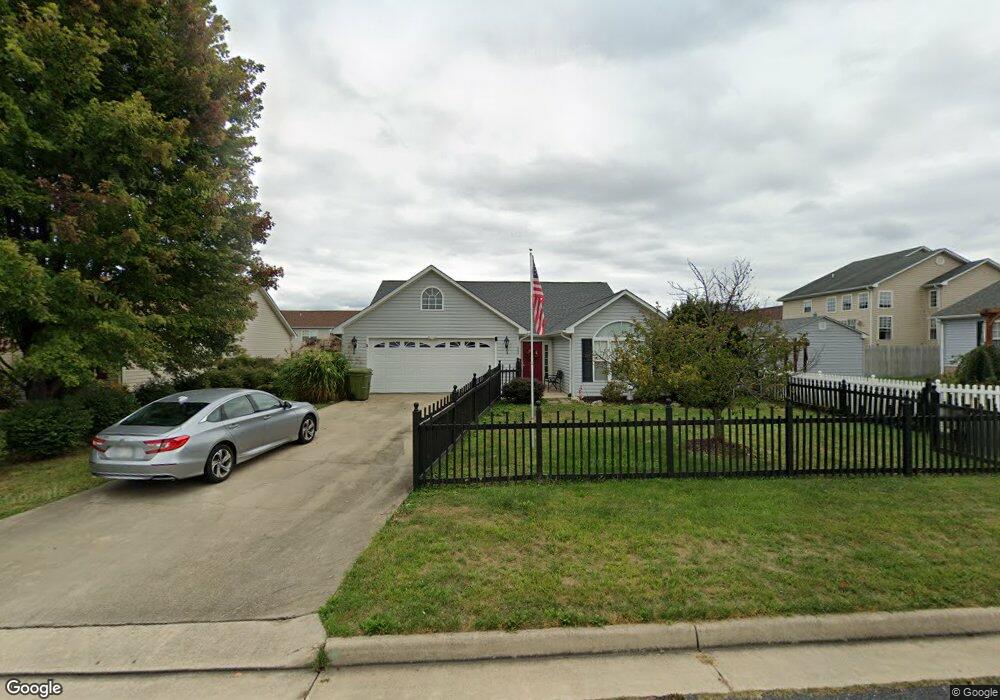
200 Mayfield Ln Waynesboro, VA 22980
Estimated Value: $341,000 - $348,604
3
Beds
2
Baths
1,637
Sq Ft
$211/Sq Ft
Est. Value
About This Home
This home is located at 200 Mayfield Ln, Waynesboro, VA 22980 and is currently estimated at $345,651, approximately $211 per square foot. 200 Mayfield Ln is a home located in Waynesboro City with nearby schools including William Perry Elementary School, Kate Collins Middle School, and Waynesboro High School.
Ownership History
Date
Name
Owned For
Owner Type
Purchase Details
Closed on
Mar 8, 2023
Sold by
Wall Allan W and Wall Rebecca G
Bought by
Wall Rebecca G
Current Estimated Value
Purchase Details
Closed on
Oct 20, 2015
Sold by
Wilson Raymond N and Wilson Wendy C
Bought by
Wall Allan W and Wall Rebecca G
Home Financials for this Owner
Home Financials are based on the most recent Mortgage that was taken out on this home.
Original Mortgage
$125,000
Interest Rate
3.92%
Mortgage Type
New Conventional
Purchase Details
Closed on
Aug 22, 2008
Sold by
Wood Stephen W
Bought by
Wilson Raymond W
Home Financials for this Owner
Home Financials are based on the most recent Mortgage that was taken out on this home.
Original Mortgage
$180,400
Interest Rate
6.4%
Mortgage Type
New Conventional
Create a Home Valuation Report for This Property
The Home Valuation Report is an in-depth analysis detailing your home's value as well as a comparison with similar homes in the area
Home Values in the Area
Average Home Value in this Area
Purchase History
| Date | Buyer | Sale Price | Title Company |
|---|---|---|---|
| Wall Rebecca G | -- | None Listed On Document | |
| Wall Allan W | $193,000 | None Available | |
| Wilson Raymond W | $225,500 | -- |
Source: Public Records
Mortgage History
| Date | Status | Borrower | Loan Amount |
|---|---|---|---|
| Previous Owner | Wall Allan W | $125,000 | |
| Previous Owner | Wilson Raymond W | $180,400 |
Source: Public Records
Tax History Compared to Growth
Tax History
| Year | Tax Paid | Tax Assessment Tax Assessment Total Assessment is a certain percentage of the fair market value that is determined by local assessors to be the total taxable value of land and additions on the property. | Land | Improvement |
|---|---|---|---|---|
| 2025 | $2,619 | $319,400 | $58,500 | $260,900 |
| 2024 | $2,148 | $278,900 | $55,000 | $223,900 |
| 2023 | $2,148 | $278,900 | $55,000 | $223,900 |
| 2022 | $2,032 | $225,800 | $45,000 | $180,800 |
| 2021 | $2,032 | $225,800 | $45,000 | $180,800 |
| 2020 | $1,913 | $212,500 | $45,000 | $167,500 |
| 2019 | $1,913 | $212,500 | $45,000 | $167,500 |
| 2018 | $1,715 | $190,600 | $45,000 | $145,600 |
| 2017 | $1,658 | $190,600 | $45,000 | $145,600 |
| 2016 | $1,411 | $176,400 | $41,000 | $135,400 |
| 2015 | $1,411 | $176,400 | $41,000 | $135,400 |
| 2014 | -- | $171,300 | $41,000 | $130,300 |
| 2013 | -- | $0 | $0 | $0 |
Source: Public Records
Map
Nearby Homes
- 340 Kingsport Rd
- 200 Bedford Rd
- 1905 Monroe St
- 7 White Birch Rd
- 177 Tomasville Dr
- 9 White Birch Rd
- 5 White Birch Rd
- 656 Edwardian Ln
- 112 Kings Ct
- 1073 Pendleton Dr
- 233 Camden Dr
- 241 Camden Dr
- 237 Camden Dr
- 2404 Village Dr
- 113 Ana Marie Blvd
- 1637 Mulberry St
- 504 Rosewood Ct
- 208 Claybrook Dr
- 108 Ana Marie Blvd
- Devon Plan at Townhomes at Evershire
- 204 Mayfield Ln
- 2329 Monroe St
- 2325 Monroe St
- 201 Rutledge Dr
- 208 Mayfield Ln
- 205 Rutledge Dr
- 209 Rutledge Dr
- 201 Mayfield Ln
- 2401 Monroe St
- 205 Mayfield Ln
- 2321 Monroe St
- 2317 Monroe St
- 209 Mayfield Ln
- 213 Rutledge Dr
- 213 Mayfield Ln
- 2405 Monroe St
- 2324 Monroe St
- 216 Mayfield Ln
- 2320 Monroe St
- 2409 Monroe St