200 Raymond Rd Lovelock, NV 89419
Estimated payment $1,080/month
Highlights
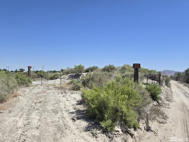
- Horses Allowed On Property
- 12.99 Acre Lot
- No HOA
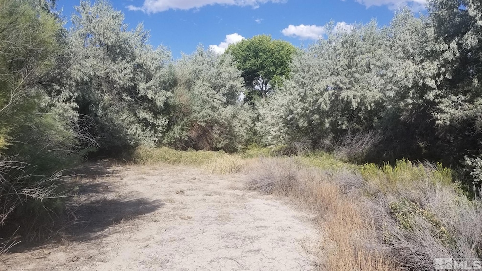
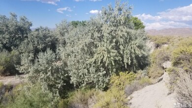
- View of Trees or Woods
- Wooded Lot
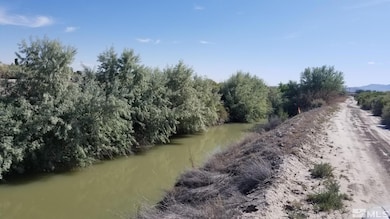
- Property is near a creek
About This Lot
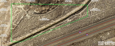
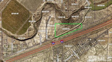
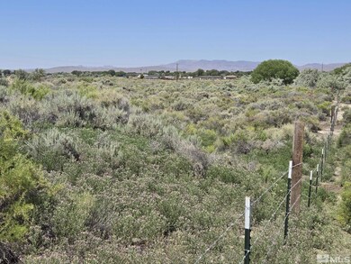
This 12.99 acres is located in the Upper Valley area of Lovelock, less than two miles northeast of the city limits. Zoned LDS (Low Density Suburban), which has a 2.5 acre lot size minimum. Adjacent property was previously divided into lots of under an acre, which may indicate higher density could be possible on this property. Just south of the Humboldt River to the north. North end of property slopes down toward the river and has lots of native trees and vegetation., 12.99 AC RESIDENTIAL LAND W/SUBDIVISION POTENTIAL This 12.99 acres is located in the Upper Valley area of Lovelock, less than two miles northeast of the city limits. Zoned LDS (Low Density Suburban), which has a 2.5 acre lot size minimum. Adjacent property was previously divided into lots of under an acre, which may indicate higher density could be possible on this property. Just south of the Humboldt River to the north, and the Rogers Canal crosses through the southern portion of the property. Shallow groundwater table thanks to both of these water bodies in immediate proximity. Plant trees, tend a garden, dig a hole and make a pond? Lots of options here. North end of property slopes down toward the river and has lots of native trees and vegetation. Electric lines are on the property and the municipal water line is stubbed out near the property boundary. Septic required to build; sewer lines too far away to connect. Property has been surveyed with corners marked. Various historic roads/driveways exist to/on the property. Located in Lovelock, Nevada. Lovelock is located about 1.25 hours east of Reno, along the I-80 corridor between Fernley and Winnemucca. Development and employment activity has been increasing in recent years in Lovelock, as the seeds for one of Nevada's next boom towns are sowed. As population levels increase this may become very valuable property. Pershing County APN 007-281-19 GPS 40.195902, -118.445977
Property Details
Property Type
- Land
Est. Annual Taxes
- $314
Lot Details
- 12.99 Acre Lot
- Property fronts a private road
- Dirt Road
- Creek or Stream
- Barbed Wire
- Desert Landscape
- Level Lot
- Open Lot
- Corners Of The Lot Have Been Marked
- Wooded Lot
- Property is zoned LDS Low Density Suburban
Property Views
- Woods
- Mountain
- Desert
Schools
- Lovelock Elementary School
- Pershing Middle School
- Pershing High School
Utilities
- Septic Needed
- Sewer Not Available
Additional Features
- Property is near a creek
- Horses Allowed On Property
Community Details
- No Home Owners Association
Listing and Financial Details
- Assessor Parcel Number 007-281-19
Map
Home Values in the Area
Average Home Value in this Area
Tax History
| Year | Tax Paid | Tax Assessment Tax Assessment Total Assessment is a certain percentage of the fair market value that is determined by local assessors to be the total taxable value of land and additions on the property. | Land | Improvement |
|---|---|---|---|---|
| 2025 | $314 | $10,500 | $10,500 | -- |
| 2024 | $314 | $10,500 | $10,500 | $0 |
| 2023 | $314 | $10,500 | $10,500 | $0 |
| 2022 | $271 | $8,324 | $8,324 | $0 |
| 2021 | $271 | $8,324 | $8,324 | $0 |
| 2020 | $271 | $8,324 | $8,324 | $0 |
| 2019 | $271 | $8,324 | $8,324 | $0 |
| 2018 | $271 | $8,324 | $8,324 | $0 |
| 2017 | $290 | $8,950 | $8,950 | $0 |
| 2016 | $290 | $8,950 | $8,950 | $0 |
| 2015 | -- | $8,950 | $8,950 | $0 |
| 2014 | -- | $8,950 | $8,950 | $0 |
Property History
| Date | Event | Price | List to Sale | Price per Sq Ft |
|---|---|---|---|---|
| 09/16/2024 09/16/24 | For Sale | $200,000 | -- | -- |
Purchase History
| Date | Type | Sale Price | Title Company |
|---|---|---|---|
| Bargain Sale Deed | $23,783 | -- | |
| Bargain Sale Deed | $23,783 | -- |
Source: Northern Nevada Regional MLS
MLS Number: 240011902
APN: 007-281-19
Disclaimer: Certain information contained herein is derived from information provided by parties other than Homes.com. All information provided is deemed reliable, but is not guaranteed to be accurate and should be independently verified.
![]() IDX information is provided exclusively for personal, non-commercial use, and may not be used for any purpose other than to identify prospective properties consumers may be interested in purchasing. Information is deemed reliable but not guaranteed. The content relating to real estate for sale on this web site comes in part from the Broker Reciprocity/ IDX program of the Northern Nevada Regional Multiple Listing Service°. Real estate listings held by brokerage firms other than Ten-X are marked with the Broker Reciprocity logo and detailed information about those listings includes the name of the listing brokerage. Any use of the content other than by a search performed by a consumer looking to purchase or rent real estate is prohibited. © 2025 Northern Nevada Regional Multiple Listing Service® MLS. All rights reserved.
IDX information is provided exclusively for personal, non-commercial use, and may not be used for any purpose other than to identify prospective properties consumers may be interested in purchasing. Information is deemed reliable but not guaranteed. The content relating to real estate for sale on this web site comes in part from the Broker Reciprocity/ IDX program of the Northern Nevada Regional Multiple Listing Service°. Real estate listings held by brokerage firms other than Ten-X are marked with the Broker Reciprocity logo and detailed information about those listings includes the name of the listing brokerage. Any use of the content other than by a search performed by a consumer looking to purchase or rent real estate is prohibited. © 2025 Northern Nevada Regional Multiple Listing Service® MLS. All rights reserved.
- 58 River Banks Ct
- 33 Cliff Banks Ct
- 135 Cessna Ln
- 750 Airport Rd
- 0 Airport Rd
- 2515 Upper Valley Rd
- 3255 Upper Valley Rd
- 5105 N Meridian Rd
- 1645 Central Ave
- 1605 Central Ave
- 750 16th St
- 1465 Central Ave
- 420 12th St
- APN 14th St
- 1075 Dartmouth Ave
- 1070 Cornell Ave
- T28 R31 Sec 27
- T33 R37 Sec 3
- 595 Taylor Place
- 1560 Grinnel Ave
