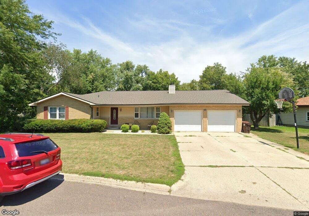
200 Ridge St Morton, IL 61550
Estimated Value: $224,152 - $263,000
3
Beds
2
Baths
1,926
Sq Ft
$130/Sq Ft
Est. Value
About This Home
This home is located at 200 Ridge St, Morton, IL 61550 and is currently estimated at $250,038, approximately $129 per square foot. 200 Ridge St is a home located in Tazewell County with nearby schools including Morton High School, Blessed Sacrament School, and Bethel Lutheran School.
Ownership History
Date
Name
Owned For
Owner Type
Purchase Details
Closed on
Dec 28, 2010
Sold by
Lefevre James B and Lefevre Sharrid E
Bought by
Laufenberg John and Laufenberg Rachel A
Current Estimated Value
Home Financials for this Owner
Home Financials are based on the most recent Mortgage that was taken out on this home.
Original Mortgage
$126,553
Interest Rate
4.5%
Mortgage Type
FHA
Create a Home Valuation Report for This Property
The Home Valuation Report is an in-depth analysis detailing your home's value as well as a comparison with similar homes in the area
Home Values in the Area
Average Home Value in this Area
Purchase History
| Date | Buyer | Sale Price | Title Company |
|---|---|---|---|
| Laufenberg John | $132,000 | Pekin Title Llc |
Source: Public Records
Mortgage History
| Date | Status | Borrower | Loan Amount |
|---|---|---|---|
| Open | Laufenberg John | $24,344 | |
| Open | Laufenberg John | $151,353 | |
| Closed | Laufenberg John | $126,553 | |
| Previous Owner | Lefevre James B | $100,000 |
Source: Public Records
Tax History
| Year | Tax Paid | Tax Assessment Tax Assessment Total Assessment is a certain percentage of the fair market value that is determined by local assessors to be the total taxable value of land and additions on the property. | Land | Improvement |
|---|---|---|---|---|
| 2024 | $3,458 | $57,050 | $9,710 | $47,340 |
| 2023 | $3,458 | $53,150 | $9,050 | $44,100 |
| 2022 | $3,306 | $48,810 | $8,310 | $40,500 |
| 2021 | $3,162 | $46,930 | $7,990 | $38,940 |
| 2020 | $3,060 | $46,460 | $7,910 | $38,550 |
| 2019 | $3,052 | $46,460 | $7,910 | $38,550 |
| 2018 | $2,996 | $46,460 | $7,910 | $38,550 |
| 2017 | $2,919 | $46,000 | $7,830 | $38,170 |
| 2016 | $2,858 | $46,000 | $7,830 | $38,170 |
| 2015 | $2,743 | $0 | $0 | $0 |
| 2013 | $2,716 | $44,300 | $7,540 | $36,760 |
Source: Public Records
Map
Nearby Homes
- 112 Caroline St
- 307 White Oak Dr Unit 307Whi
- 219 White Oak Dr Unit 219Whi
- 105 Hemlock Dr Unit 105Hem
- 106 Mulberry Dr Unit 108Mul
- 108 Cottonwood Dr Unit 108Cot
- 111 Cottonwood Dr Unit 111Cot
- 110 White Oak Dr Unit 110Whi
- 116 Hickory Dr Unit 116Hic
- 113 Happ Ln
- 120 Cottonwood Dr Unit 120Cot
- 105 Willow Oak Dr Unit 105Wil
- 26 Linden Ct
- 2223 Veterans Rd Unit 21
- 417 Lilac Ln
- 71 Sapphire Point
- 31 Sapphire Point
- 307 Beverly Ave
- 22623 Veterans Rd
- 200 Lilac Ln
Your Personal Tour Guide
Ask me questions while you tour the home.