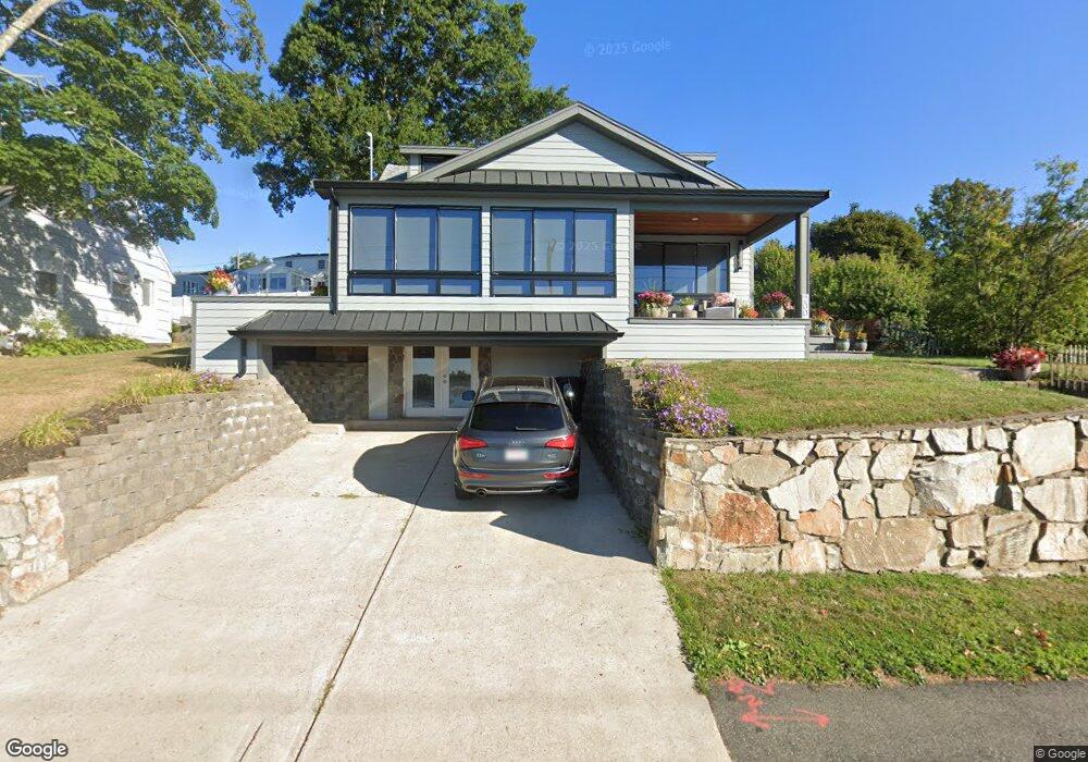
200 River St North Weymouth, MA 02191
North Weymouth NeighborhoodEstimated Value: $712,000 - $779,313
3
Beds
2
Baths
1,696
Sq Ft
$439/Sq Ft
Est. Value
About This Home
This home is located at 200 River St, North Weymouth, MA 02191 and is currently estimated at $744,828, approximately $439 per square foot. 200 River St is a home located in Norfolk County with nearby schools including Wessagusset Elementary School, Abigail Adams Middle School, and Weymouth Middle School Chapman.
Ownership History
Date
Name
Owned For
Owner Type
Purchase Details
Closed on
Dec 5, 2007
Sold by
Ciarlone Joseph B
Bought by
Ciarlone Joseph and Ciarlone Shari
Current Estimated Value
Purchase Details
Closed on
Mar 21, 2006
Sold by
Stump Eddie H
Bought by
Ciarlone Joseph B
Home Financials for this Owner
Home Financials are based on the most recent Mortgage that was taken out on this home.
Original Mortgage
$269,500
Interest Rate
6.27%
Mortgage Type
Purchase Money Mortgage
Purchase Details
Closed on
Jul 15, 2004
Sold by
Stump Eddie H
Bought by
Stump Ft
Purchase Details
Closed on
May 3, 2004
Sold by
Sinclair Jean and Williams Thomas F
Bought by
Stump Eddie H and Stump Sandra A
Create a Home Valuation Report for This Property
The Home Valuation Report is an in-depth analysis detailing your home's value as well as a comparison with similar homes in the area
Home Values in the Area
Average Home Value in this Area
Purchase History
| Date | Buyer | Sale Price | Title Company |
|---|---|---|---|
| Ciarlone Joseph | -- | -- | |
| Ciarlone Joseph | -- | -- | |
| Ciarlone Joseph B | $371,000 | -- | |
| Stump Ft | -- | -- | |
| Stump Eddie H | $238,000 | -- |
Source: Public Records
Mortgage History
| Date | Status | Borrower | Loan Amount |
|---|---|---|---|
| Previous Owner | Ciarlone Joseph B | $269,500 |
Source: Public Records
Tax History Compared to Growth
Tax History
| Year | Tax Paid | Tax Assessment Tax Assessment Total Assessment is a certain percentage of the fair market value that is determined by local assessors to be the total taxable value of land and additions on the property. | Land | Improvement |
|---|---|---|---|---|
| 2025 | $7,117 | $704,700 | $262,800 | $441,900 |
| 2024 | $6,957 | $677,400 | $250,300 | $427,100 |
| 2023 | $6,619 | $633,400 | $231,700 | $401,700 |
| 2022 | $6,044 | $527,400 | $214,600 | $312,800 |
| 2021 | $5,641 | $480,500 | $214,600 | $265,900 |
| 2020 | $5,427 | $455,300 | $214,600 | $240,700 |
| 2019 | $5,298 | $437,100 | $206,300 | $230,800 |
| 2018 | $5,139 | $411,100 | $196,500 | $214,600 |
| 2017 | $5,057 | $394,800 | $187,200 | $207,600 |
| 2016 | $4,860 | $379,700 | $180,000 | $199,700 |
| 2015 | $4,678 | $362,600 | $180,000 | $182,600 |
| 2014 | $4,567 | $343,400 | $179,900 | $163,500 |
Source: Public Records
Map
Nearby Homes
- 16 Caldwell St
- 51 Broad Reach Unit T23A
- 61 Broad Reach Unit T62B
- 73 Broad Reach Unit T123C
- 73 Broad Reach Unit M33C
- 73 Broad Reach Unit T41C
- 12 Wolcott St
- 130 Broad Reach Unit 506
- 130 Broad Reach Unit 305
- 130 Broad Reach Unit 206
- 130 Broad Reach Unit 504
- 10 Shipyard Dr Unit 313
- 69 Great Hill Dr
- 141 Hms Stayner Dr Unit 306
- 125 Halsted Dr Unit 125
- 16 Beal's Cove Rd Unit E
- 95 Fuller Rd
- 2 Beach Ln
- 6 Beal's Cove Rd Unit G
- 17 Beals Cove Rd Unit A
- 200 River St (Waterfront)
- 196 River St
- 204 River St
- 114 Prospect Hill Dr
- 118 Prospect Hill Dr
- 190 River St
- 110 Prospect Hill Dr
- 122 Prospect Hill Dr
- 184 River St
- 216 River St
- 56 Canacum Rd
- 126 Prospect Hill Dr
- 109 Prospect Hill Dr
- 50 Canacum Rd
- 115 Prospect Hill Dr
- 180 River St
- 101 Prospect Hill Dr
- 226 River St
- 36 Hilltop Rd
- 40 Canacum Rd