
Seller's Agent in 2025
Julie Etter
Berkshire Hathaway HomeServices Evolution Properties
(508) 259-3025
57 in this area
325 Total Sales
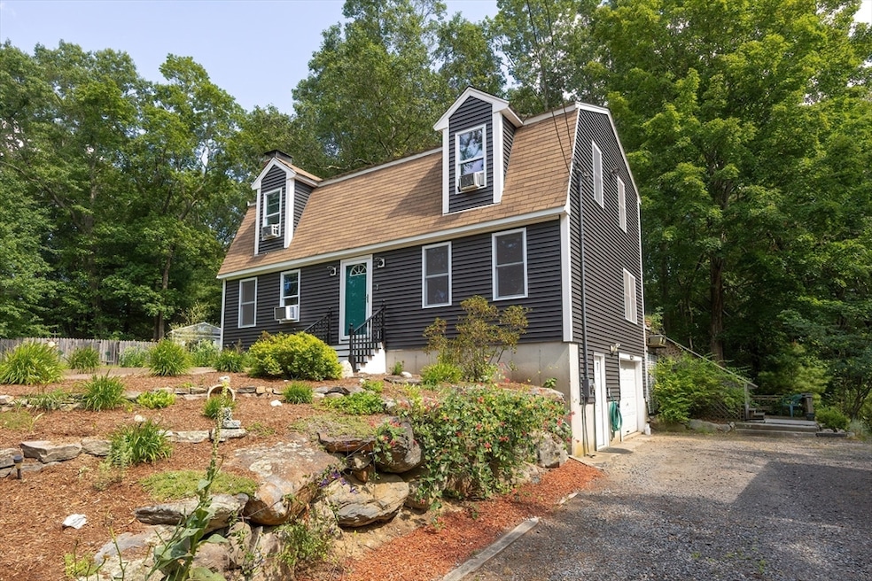
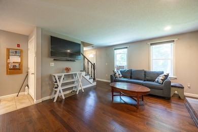
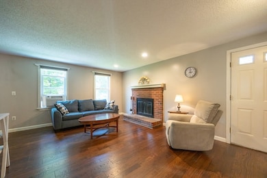

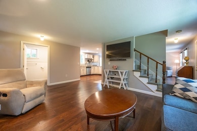
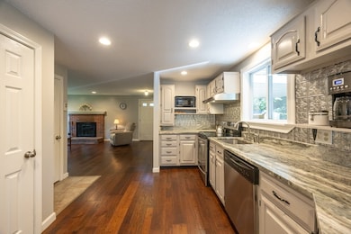
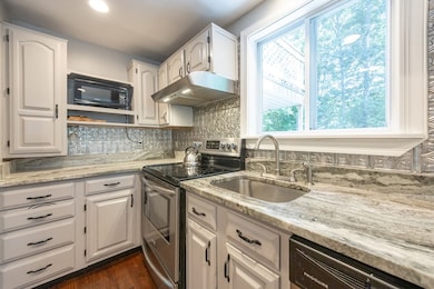
Ideally tucked away and full of serenity is this well maintained, aesthetically pleasing and updated home! Adorned with a magazine quality updated kitchen, gatherings are welcomed here, or on the expansive and private rear deck! Sip your coffee on your choice of porches, or Juliette balcony, and appreciate wildlife in your beautiful yard! Neutral decor and a wide open floor plan enhance the ability for both formal and casual living on the first floor, while oversized bedrooms provide needed privacy upstairs! Storage abounds in the walk out basement or garage, ideal for the hobbyist, or day to day tools. Obvious care has gone into maintenance, prideful yard additions and quality of finishings! Young roof (approx 7 years), oil tank (2024), hot water tank (approx 4 years) windows (10-15 years). A feeling of home only a long term owner can provide and a wide open floor plan ready for your family's best use!
Last Agent to Sell the Property
Berkshire Hathaway HomeServices Evolution Properties Listed on: 07/23/2025
| Date | Type | Sale Price | Title Company |
|---|---|---|---|
| Quit Claim Deed | $575,000 | -- | |
| Deed | $122,000 | -- |
| Date | Status | Loan Amount | Loan Type |
|---|---|---|---|
| Open | $460,000 | New Conventional | |
| Previous Owner | $179,000 | No Value Available | |
| Previous Owner | $181,250 | No Value Available | |
| Previous Owner | $120,500 | No Value Available |
| Date | Event | Price | List to Sale | Price per Sq Ft |
|---|---|---|---|---|
| 10/09/2025 10/09/25 | Sold | $575,000 | -4.2% | $333 / Sq Ft |
| 08/02/2025 08/02/25 | Pending | -- | -- | -- |
| 07/23/2025 07/23/25 | For Sale | $599,900 | -- | $347 / Sq Ft |
| Year | Tax Paid | Tax Assessment Tax Assessment Total Assessment is a certain percentage of the fair market value that is determined by local assessors to be the total taxable value of land and additions on the property. | Land | Improvement |
|---|---|---|---|---|
| 2025 | $65 | $497,500 | $185,900 | $311,600 |
| 2024 | $6,188 | $477,800 | $177,000 | $300,800 |
| 2023 | $5,857 | $450,900 | $167,000 | $283,900 |
| 2022 | $5,667 | $397,400 | $151,800 | $245,600 |
| 2021 | $0 | $363,400 | $144,600 | $218,800 |
| 2020 | $4,817 | $352,900 | $140,400 | $212,500 |
| 2019 | $4,953 | $332,400 | $127,900 | $204,500 |
| 2018 | $0 | $324,800 | $127,900 | $196,900 |
| 2017 | $4,626 | $301,000 | $127,900 | $173,100 |
| 2016 | $4,460 | $285,700 | $127,900 | $157,800 |
| 2015 | $4,315 | $280,400 | $124,400 | $156,000 |
| 2014 | $4,108 | $267,300 | $118,500 | $148,800 |
Seller's Agent in 2025
Julie Etter
Berkshire Hathaway HomeServices Evolution Properties
(508) 259-3025
57 in this area
325 Total Sales
S
Buyer's Agent in 2025
Sisters Selling Team
Keller Williams Elite
(508) 695-4545
3 in this area
23 Total Sales
Source: MLS Property Information Network (MLS PIN)
MLS Number: 73408382
APN: NORT-000027-000000-000179
Disclaimer: Certain information contained herein is derived from information provided by parties other than Homes.com. All information provided is deemed reliable, but is not guaranteed to be accurate and should be independently verified.
![]() The property listing data and information, or the Images, set forth herein were provided to MLS Property Information Network, Inc. from third party sources, including sellers, lessors and public records, and were compiled by MLS Property Information Network, Inc. The property listing data and information, and the Images, are for the personal, non-commercial use of consumers having a good faith interest in purchasing or leasing listed properties of the type displayed to them and may not be used for any purpose other than to identify prospective properties which such consumers may have a good faith interest in purchasing or leasing. MLS Property Information Network, Inc. and its subscribers disclaim any and all representations and warranties as to the accuracy of the property listing data and information, or as to the accuracy of any of the Images, set forth herein.
The property listing data and information, or the Images, set forth herein were provided to MLS Property Information Network, Inc. from third party sources, including sellers, lessors and public records, and were compiled by MLS Property Information Network, Inc. The property listing data and information, and the Images, are for the personal, non-commercial use of consumers having a good faith interest in purchasing or leasing listed properties of the type displayed to them and may not be used for any purpose other than to identify prospective properties which such consumers may have a good faith interest in purchasing or leasing. MLS Property Information Network, Inc. and its subscribers disclaim any and all representations and warranties as to the accuracy of the property listing data and information, or as to the accuracy of any of the Images, set forth herein.
Ask me questions while you tour the home.