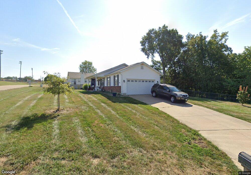
200 Sandra Way Winfield, MO 63389
Estimated Value: $248,369 - $258,000
3
Beds
3
Baths
1,164
Sq Ft
$218/Sq Ft
Est. Value
About This Home
This home is located at 200 Sandra Way, Winfield, MO 63389 and is currently estimated at $253,342, approximately $217 per square foot. 200 Sandra Way is a home located in Lincoln County with nearby schools including Winfield Primary School, Winfield Intermediate School, and Winfield Middle School.
Ownership History
Date
Name
Owned For
Owner Type
Purchase Details
Closed on
Jan 1, 2021
Sold by
March Julia L and Deering Julia L
Bought by
Deering Julia L and Deering Bruce
Current Estimated Value
Home Financials for this Owner
Home Financials are based on the most recent Mortgage that was taken out on this home.
Original Mortgage
$87,559
Outstanding Balance
$63,208
Interest Rate
2.1%
Mortgage Type
New Conventional
Estimated Equity
$190,134
Purchase Details
Closed on
Mar 26, 2009
Sold by
Deering Julia L and March Julia L
Bought by
March Julia L and Deering Julia L
Create a Home Valuation Report for This Property
The Home Valuation Report is an in-depth analysis detailing your home's value as well as a comparison with similar homes in the area
Purchase History
We collect this data history from publicly available records. To have your information removed, we recommend requesting removal directly through your county’s website.
| Date | Buyer | Sale Price | Title Company |
|---|---|---|---|
| Deering Julia L | -- | None Available | |
| March Julia L | -- | None Available |
Source: Public Records
Mortgage History
We collect this data history from publicly available records. To have your information removed, we recommend requesting removal directly through your county’s website.
| Date | Status | Borrower | Loan Amount |
|---|---|---|---|
| Open | Deering Julia L | $87,559 |
Source: Public Records
Tax History
| Year | Tax Paid | Tax Assessment Tax Assessment Total Assessment is a certain percentage of the fair market value that is determined by local assessors to be the total taxable value of land and additions on the property. | Land | Improvement |
|---|---|---|---|---|
| 2025 | $1,687 | $27,844 | $3,800 | $24,044 |
| 2024 | $1,540 | $25,433 | $2,850 | $22,583 |
| 2023 | $1,545 | $25,433 | $2,850 | $22,583 |
| 2022 | $1,466 | $24,309 | $2,850 | $21,459 |
| 2021 | $1,473 | $127,940 | $0 | $0 |
| 2020 | $1,251 | $111,240 | $0 | $0 |
| 2019 | $1,253 | $111,240 | $0 | $0 |
| 2018 | $1,291 | $21,529 | $0 | $0 |
| 2017 | $1,295 | $21,529 | $0 | $0 |
| 2016 | $1,207 | $19,542 | $0 | $0 |
| 2015 | $1,215 | $19,542 | $0 | $0 |
| 2014 | $1,204 | $19,542 | $0 | $0 |
| 2013 | -- | $19,542 | $0 | $0 |
Source: Public Records
Map
Nearby Homes
- 431 Peregrine Ct
- E Highway 47 E State Highway 47
- 220 Kitson Rd
- 512 W Cherry St
- Lot #21 West Ave
- 344 Fourbush Ct
- 350 Birkhead Rd
- 671 Birkhead Rd
- 25 Rolfes Ln
- 757 Birkhead Rd
- 3 Winfield Plaza
- 55 Lake Bend Dr
- 35 Woodline Dr
- 69 Walnut Grove Dr
- 329 Lakeview Rd
- 74 Ackerman Ct
- 280 Sycamore Ln
- 619 N Ethlyn Rd
- 140 N Ethlyn Rd
- 112 Canyon Creek Cir
Your Personal Tour Guide
Ask me questions while you tour the home.