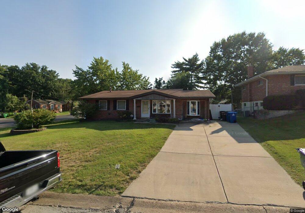
200 Southwark Ln Saint Louis, MO 63125
Lemay NeighborhoodEstimated Value: $241,000 - $255,000
4
Beds
2
Baths
1,404
Sq Ft
$177/Sq Ft
Est. Value
About This Home
This home is located at 200 Southwark Ln, Saint Louis, MO 63125 and is currently estimated at $248,783, approximately $177 per square foot. 200 Southwark Ln is a home located in St. Louis County with nearby schools including Hancock Place Elementary School, Hancock Place Middle School, and Hancock Place High School.
Ownership History
Date
Name
Owned For
Owner Type
Purchase Details
Closed on
Dec 3, 2021
Sold by
Turner Jr Thomas R
Bought by
Turner Thomas R
Current Estimated Value
Home Financials for this Owner
Home Financials are based on the most recent Mortgage that was taken out on this home.
Original Mortgage
$156,000
Outstanding Balance
$122,031
Interest Rate
2.37%
Mortgage Type
New Conventional
Estimated Equity
$126,752
Create a Home Valuation Report for This Property
The Home Valuation Report is an in-depth analysis detailing your home's value as well as a comparison with similar homes in the area
Home Values in the Area
Average Home Value in this Area
Purchase History
| Date | Buyer | Sale Price | Title Company |
|---|---|---|---|
| Turner Thomas R | $207,480 | New Title Company Name | |
| Turner Thomas R | -- | New Title Company Name |
Source: Public Records
Mortgage History
| Date | Status | Borrower | Loan Amount |
|---|---|---|---|
| Open | Turner Thomas R | $156,000 | |
| Closed | Turner Thomas R | $156,000 |
Source: Public Records
Tax History Compared to Growth
Tax History
| Year | Tax Paid | Tax Assessment Tax Assessment Total Assessment is a certain percentage of the fair market value that is determined by local assessors to be the total taxable value of land and additions on the property. | Land | Improvement |
|---|---|---|---|---|
| 2025 | $3,088 | $40,620 | $13,680 | $26,940 |
| 2024 | $3,088 | $40,000 | $5,570 | $34,430 |
| 2023 | $3,088 | $40,000 | $5,570 | $34,430 |
| 2022 | $2,609 | $32,230 | $5,570 | $26,660 |
| 2021 | $2,564 | $32,230 | $5,570 | $26,660 |
| 2020 | $2,340 | $28,080 | $5,360 | $22,720 |
| 2019 | $2,334 | $28,080 | $5,360 | $22,720 |
| 2018 | $2,190 | $22,970 | $4,160 | $18,810 |
| 2017 | $2,152 | $22,970 | $4,160 | $18,810 |
| 2016 | $2,108 | $21,680 | $2,960 | $18,720 |
| 2015 | $2,097 | $21,680 | $2,960 | $18,720 |
| 2014 | $1,854 | $20,350 | $4,920 | $15,430 |
Source: Public Records
Map
Nearby Homes
- 385 Kingston Dr
- 317 Tacoma Dr
- 304 Southampton Dr
- 502 Nannette Dr
- 333 Pentonville Dr
- 600 Ellwine Dr
- 2228 Hagenstone Terrace
- 121 Jefferson Barracks Rd
- 669 Vista Conn Dr
- 645 Vista Conn Dr
- 660 Rochester Dr
- 2105 Telford Dr
- 669 Bellsworth Dr
- 9950 Meadow Ave
- 408 W Ripa Ave
- 2745 Granda Dr
- 205 Grover Rd
- 308 Carthage Ave
- 9954 Luna Ave
- 9953 Sadie Ave
- 208 Southwark Ln
- 211 Tacoma Dr
- 201 Southwark Ln
- 389 Kingston Dr
- 215 Tacoma Dr
- 207 Southwark Ln
- 214 Southwark Ln
- 221 Tacoma Dr
- 211 Southwark Ln
- 384 Kingston Dr
- 223 Tacoma Dr
- 215 Southwark Ln
- 401 Kingston Dr
- 200 Earlsfield Ln
- 386 Kingston Dr
- 362 Kingston Dr
- 208 Earlsfield Ln
- 352 Kingston Dr
- 392 Kingston Dr
- 212 Earlsfield Ln