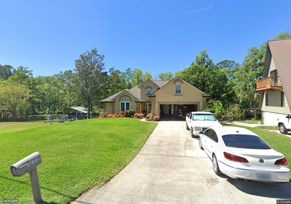
2000 Cornell Rd Middleburg, FL 32068
Estimated Value: $401,579 - $478,000
3
Beds
2
Baths
2,152
Sq Ft
$205/Sq Ft
Est. Value
About This Home
This home is located at 2000 Cornell Rd, Middleburg, FL 32068 and is currently estimated at $440,145, approximately $204 per square foot. 2000 Cornell Rd is a home located in Clay County with nearby schools including Middleburg Elementary School, Middleburg High School, and Lake Asbury Junior High School.
Ownership History
Date
Name
Owned For
Owner Type
Purchase Details
Closed on
Jan 21, 2011
Sold by
Jones Jackie L and Jones Carol A
Bought by
Jones Jackie L and Jones Carol A
Current Estimated Value
Home Financials for this Owner
Home Financials are based on the most recent Mortgage that was taken out on this home.
Original Mortgage
$266,000
Outstanding Balance
$180,095
Interest Rate
4.79%
Mortgage Type
VA
Estimated Equity
$260,050
Purchase Details
Closed on
Jan 9, 2002
Sold by
Louis L Huntley Enterprises Inc
Bought by
Jones Jack L and Jones Carol A
Home Financials for this Owner
Home Financials are based on the most recent Mortgage that was taken out on this home.
Original Mortgage
$177,470
Interest Rate
7.16%
Mortgage Type
Construction
Create a Home Valuation Report for This Property
The Home Valuation Report is an in-depth analysis detailing your home's value as well as a comparison with similar homes in the area
Home Values in the Area
Average Home Value in this Area
Purchase History
| Date | Buyer | Sale Price | Title Company |
|---|---|---|---|
| Jones Jackie L | -- | None Available | |
| Jones Jack L | -- | -- |
Source: Public Records
Mortgage History
| Date | Status | Borrower | Loan Amount |
|---|---|---|---|
| Open | Jones Jackie L | $266,000 | |
| Closed | Jones Jack L | $177,470 |
Source: Public Records
Tax History
| Year | Tax Paid | Tax Assessment Tax Assessment Total Assessment is a certain percentage of the fair market value that is determined by local assessors to be the total taxable value of land and additions on the property. | Land | Improvement |
|---|---|---|---|---|
| 2025 | $2,483 | $216,114 | -- | -- |
| 2024 | $2,956 | $210,024 | -- | -- |
| 2023 | $2,956 | $203,907 | $0 | $0 |
| 2022 | $2,757 | $197,968 | $0 | $0 |
| 2021 | $2,532 | $192,202 | $0 | $0 |
| 2020 | $2,657 | $189,549 | $0 | $0 |
| 2019 | $2,618 | $185,288 | $0 | $0 |
| 2018 | $2,420 | $181,833 | $0 | $0 |
| 2017 | $2,406 | $178,093 | $0 | $0 |
| 2016 | $2,400 | $174,430 | $0 | $0 |
| 2015 | $2,456 | $173,217 | $0 | $0 |
| 2014 | $2,399 | $171,842 | $0 | $0 |
Source: Public Records
Map
Nearby Homes
- 2060 Cornell Rd
- 2051 Cornell Rd
- 2139 2143 Charter Pointe Way
- 0 Charter Pointe Way
- 0 Main St Unit 2099304
- 3716 Main St
- 0 Blanding Blvd Unit 2103998
- 2246 Palisade Point
- 2498 Jennings Farm Dr
- 2326 North St
- 2280 Brannings Sawmill Ct
- 2260 Brannings Sawmill Ct
- 2264 Brannings Sawmill Ct
- 2487 Jennings Farm Dr
- 2481 Jennings Farm Dr
- 2230 Palisade Point
- 2265 Brannings Sawmill Ct
- 3986 Country Meadows Dr
- 2475 Jennings Farm Dr
- 2220 Palisade Point
- 1998 Cornell Rd
- 2002 Cornell Rd
- 1994 Cornell Rd
- 2006 Cornell Rd
- 1999 Cornell Rd
- 2003 Cornell Rd
- 2010 Cornell Rd
- 1992 Cornell Rd
- 1991 Cornell Rd
- 2008 Cornell Rd
- 2007 Cornell Rd
- 2012 Cornell Rd
- 1985 Cornell Rd
- 1990 Cornell Rd
- 2011 Cornell Rd
- 1988 Cornell Rd
- 2014 Cornell Rd
- 1981 Cornell Rd
- 2015 Cornell Rd
- 138 S Lee Dr
Your Personal Tour Guide
Ask me questions while you tour the home.