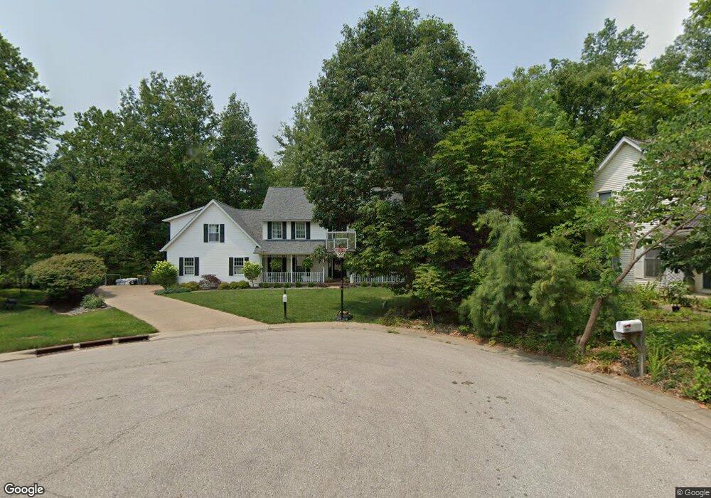
2000 E Ashwood Ln Bloomington, IN 47401
Estimated Value: $578,000 - $656,000
3
Beds
4
Baths
3,681
Sq Ft
$165/Sq Ft
Est. Value
About This Home
This home is located at 2000 E Ashwood Ln, Bloomington, IN 47401 and is currently estimated at $606,320, approximately $164 per square foot. 2000 E Ashwood Ln is a home located in Monroe County with nearby schools including Childs Elementary School, Jackson Creek Middle School, and Bloomington High School South.
Ownership History
Date
Name
Owned For
Owner Type
Purchase Details
Closed on
Apr 20, 2018
Sold by
Riveire Patricia J
Bought by
Riveire Patricia J and Stumpf Jeffrey D
Current Estimated Value
Purchase Details
Closed on
May 3, 2017
Sold by
Riveire Jon T
Bought by
Riveire Patrica J
Purchase Details
Closed on
Jun 11, 2010
Sold by
Cooksey Charles B
Bought by
Riveire Jon T and Riveire Patricia J
Home Financials for this Owner
Home Financials are based on the most recent Mortgage that was taken out on this home.
Original Mortgage
$250,000
Interest Rate
5.05%
Mortgage Type
New Conventional
Create a Home Valuation Report for This Property
The Home Valuation Report is an in-depth analysis detailing your home's value as well as a comparison with similar homes in the area
Purchase History
| Date | Buyer | Sale Price | Title Company |
|---|---|---|---|
| Riveire Patricia J | -- | None Available | |
| Riveire Patrica J | -- | None Available | |
| Riveire Jon T | -- | None Available |
Source: Public Records
Mortgage History
| Date | Status | Borrower | Loan Amount |
|---|---|---|---|
| Previous Owner | Riveire Jon T | $250,000 |
Source: Public Records
Tax History
| Year | Tax Paid | Tax Assessment Tax Assessment Total Assessment is a certain percentage of the fair market value that is determined by local assessors to be the total taxable value of land and additions on the property. | Land | Improvement |
|---|---|---|---|---|
| 2025 | $5,666 | $490,300 | $99,600 | $390,700 |
| 2024 | $5,666 | $502,900 | $99,600 | $403,300 |
| 2023 | $2,781 | $498,500 | $99,600 | $398,900 |
| 2022 | $5,176 | $467,400 | $99,600 | $367,800 |
| 2021 | $4,493 | $427,100 | $99,600 | $327,500 |
| 2020 | $4,066 | $385,600 | $99,600 | $286,000 |
| 2019 | $4,089 | $386,400 | $62,300 | $324,100 |
| 2018 | $4,051 | $381,900 | $61,600 | $320,300 |
| 2017 | $4,119 | $387,300 | $61,600 | $325,700 |
| 2016 | $4,041 | $379,600 | $61,600 | $318,000 |
| 2014 | $3,953 | $370,600 | $61,600 | $309,000 |
Source: Public Records
Map
Nearby Homes
- 3504 S Ashwood Dr
- 1529 E Dunstan Dr
- 3434 S Ashwood Dr
- 2406 E Cedarwood Ct
- 2410 E Cedarwood Ct
- 3809 S Mill Stone Ct
- 3416 S Claybridge Dr
- 2512 E Caray Ct
- 3215 S Abby Ln
- 1730 E Camby Ln
- 3206 S Allendale Dr
- 3019 S Xavier Ct
- 3225 S Coppertree Dr
- 485 E Rhorer Rd
- 1134 E Regency Dr
- 3504 S Oaklawn Cir
- 3100 S Autumn Ct
- 1715 E Wexley Rd
- 3811 S Pepper Chase
- 1171 E Carnaby St
- 2002 E Ashwood Ln
- 2001 E Ashwood Ln
- 2008 E Ashwood Ln
- 3516 S Ashwood Dr
- 2100 E Ashwood Ln
- 3512 S Ashwood Dr
- 2104 E Ashwood Ln
- 3517 S Ashwood Dr
- 3509 S Ashwood Dr
- 2108 E Ashwood Ln
- 2107 E Ashwood Ln
- 2301 E Pierson Ct
- 2305 E Pierson Ct
- 2200 E Ashwood Cir
- 2110 E Ashwood Ln
- 2111 E Ashwood Ln
- 2210 E Ashwood Cir
- 2304 E Pierson Ct
- 3500 S Ashwood Dr
- 2309 E Pierson Ct
Your Personal Tour Guide
Ask me questions while you tour the home.