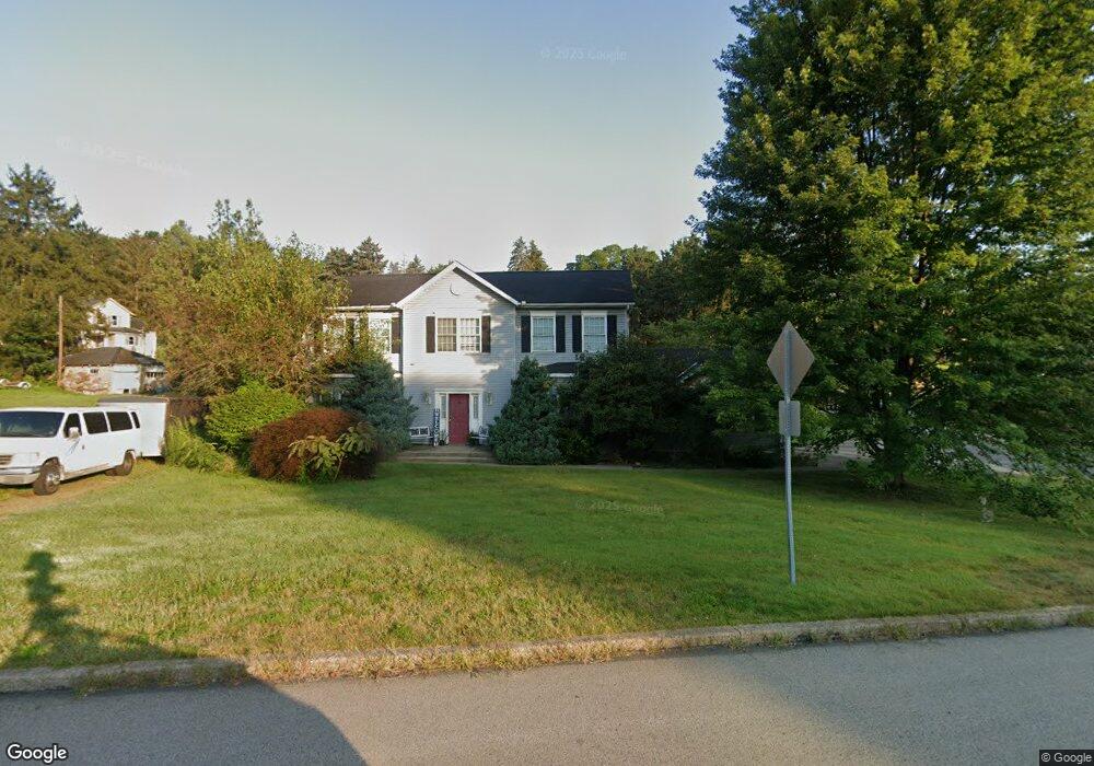
2000 Homestead Duquesne Rd West Mifflin, PA 15122
Estimated Value: $250,954 - $334,000
3
Beds
2
Baths
2,168
Sq Ft
$134/Sq Ft
Est. Value
About This Home
This home is located at 2000 Homestead Duquesne Rd, West Mifflin, PA 15122 and is currently estimated at $289,739, approximately $133 per square foot. 2000 Homestead Duquesne Rd is a home located in Allegheny County with nearby schools including West Mifflin Area High School, St Agnes School, and Walnut Grove Christian School.
Ownership History
Date
Name
Owned For
Owner Type
Purchase Details
Closed on
Dec 22, 2011
Sold by
First Commonwealth Bank
Bought by
Pitchford Gemma L
Current Estimated Value
Home Financials for this Owner
Home Financials are based on the most recent Mortgage that was taken out on this home.
Original Mortgage
$4,615
Interest Rate
4%
Mortgage Type
Second Mortgage Made To Cover Down Payment
Purchase Details
Closed on
Jun 7, 2001
Sold by
Banyas Mathilda C and Banyas John R
Bought by
Harris John W and Harris Susan E
Create a Home Valuation Report for This Property
The Home Valuation Report is an in-depth analysis detailing your home's value as well as a comparison with similar homes in the area
Home Values in the Area
Average Home Value in this Area
Purchase History
| Date | Buyer | Sale Price | Title Company |
|---|---|---|---|
| Pitchford Gemma L | $137,500 | -- | |
| Cherevka Chad M | $84,357 | -- | |
| Harris John W | $59,900 | Chicago Title Insurance Co |
Source: Public Records
Mortgage History
| Date | Status | Borrower | Loan Amount |
|---|---|---|---|
| Closed | Cherevka Chad M | $4,615 | |
| Open | Cherevka Chad M | $134,013 |
Source: Public Records
Tax History Compared to Growth
Tax History
| Year | Tax Paid | Tax Assessment Tax Assessment Total Assessment is a certain percentage of the fair market value that is determined by local assessors to be the total taxable value of land and additions on the property. | Land | Improvement |
|---|---|---|---|---|
| 2025 | $6,277 | $134,100 | $10,800 | $123,300 |
| 2024 | $6,277 | $134,100 | $10,800 | $123,300 |
| 2023 | $6,193 | $134,100 | $10,800 | $123,300 |
| 2022 | $6,012 | $134,100 | $10,800 | $123,300 |
| 2021 | $5,294 | $134,100 | $10,800 | $123,300 |
| 2020 | $5,872 | $134,100 | $10,800 | $123,300 |
| 2019 | $5,796 | $152,100 | $10,800 | $141,300 |
| 2018 | $719 | $152,100 | $10,800 | $141,300 |
| 2017 | $5,644 | $152,100 | $10,800 | $141,300 |
| 2016 | $719 | $152,100 | $10,800 | $141,300 |
| 2015 | $719 | $152,100 | $10,800 | $141,300 |
| 2014 | $5,594 | $152,100 | $10,800 | $141,300 |
Source: Public Records
Map
Nearby Homes
- 2001 Ohio Ave
- 2002 Vermont Ave
- 2123 Worton Blvd
- 2103 Vermont Ave
- 1933 Pennsylvania Ave
- 1860 Ohio Ave
- 2154 Vermont Ave
- 1823 Texas Ave
- 2247 Vermont Ave
- 2634 Homestead Duquesne Rd
- 1728 Iowa Ave
- 2301 Vermont Ave
- 1732 Pennsylvania Ave
- lot Sunset Dr
- 2813 Glenny Lane Extension
- - Mellon St
- 200 Thomas St
- 622 Ascension Dr E
- 1606 Maryland Ave
- 118 Doney St
- 2000 Homestead Duquesne Rd
- 2002 Homestead Duquesne Rd
- 2006 Purdy St
- 2001 Homestead Duquesne Rd
- 2005 Homestead Duquesne Rd
- 1964 Homestead Duquesne Rd
- 1975 Michigan Ave
- 1975 Homestead Duquesne Rd
- 2013 Homestead Duquesne Rd
- 1962 Homestead Duquesne Rd
- 2036 Homestead Duquesne Rd
- 2028 Ohio Ave
- 2020 Ohio Ave
- 2024 Ohio Ave
- 2021 Homestead Duquesne Rd
- 2016 Ohio Ave
- 1969 Michigan Ave
- 1976 Michigan Ave
- 1960 Homestead Duquesne Rd
- 2012 Ohio Ave