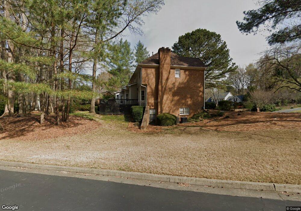
2000 Pillargate Dr Unit 2 Alpharetta, GA 30022
Doublegate NeighborhoodEstimated Value: $867,851 - $910,000
5
Beds
3
Baths
2,908
Sq Ft
$304/Sq Ft
Est. Value
About This Home
This home is located at 2000 Pillargate Dr Unit 2, Alpharetta, GA 30022 and is currently estimated at $883,463, approximately $303 per square foot. 2000 Pillargate Dr Unit 2 is a home located in Fulton County with nearby schools including State Bridge Crossing Elementary School, Autrey Mill Middle School, and Johns Creek High School.
Ownership History
Date
Name
Owned For
Owner Type
Purchase Details
Closed on
Aug 22, 2006
Sold by
Bowen Kevin
Bought by
Manswell Corinne
Current Estimated Value
Home Financials for this Owner
Home Financials are based on the most recent Mortgage that was taken out on this home.
Original Mortgage
$328,000
Outstanding Balance
$196,605
Interest Rate
6.73%
Mortgage Type
New Conventional
Estimated Equity
$686,858
Purchase Details
Closed on
May 15, 1997
Sold by
Tubman Neil S and Tubman Eve J
Bought by
Bowen Kevin P and Bowen Susan E
Home Financials for this Owner
Home Financials are based on the most recent Mortgage that was taken out on this home.
Original Mortgage
$210,900
Interest Rate
7.5%
Mortgage Type
New Conventional
Create a Home Valuation Report for This Property
The Home Valuation Report is an in-depth analysis detailing your home's value as well as a comparison with similar homes in the area
Home Values in the Area
Average Home Value in this Area
Purchase History
| Date | Buyer | Sale Price | Title Company |
|---|---|---|---|
| Manswell Corinne | $410,000 | -- | |
| Bowen Kevin P | $222,000 | -- |
Source: Public Records
Mortgage History
| Date | Status | Borrower | Loan Amount |
|---|---|---|---|
| Open | Manswell Corinne | $328,000 | |
| Previous Owner | Bowen Kevin P | $210,900 |
Source: Public Records
Tax History Compared to Growth
Tax History
| Year | Tax Paid | Tax Assessment Tax Assessment Total Assessment is a certain percentage of the fair market value that is determined by local assessors to be the total taxable value of land and additions on the property. | Land | Improvement |
|---|---|---|---|---|
| 2025 | $9,520 | $334,360 | $124,760 | $209,600 |
| 2023 | $6,749 | $239,120 | $54,800 | $184,320 |
| 2022 | $6,775 | $220,800 | $48,840 | $171,960 |
| 2021 | $6,606 | $209,680 | $51,080 | $158,600 |
| 2020 | $6,390 | $198,520 | $56,280 | $142,240 |
| 2019 | $710 | $180,040 | $50,800 | $129,240 |
| 2018 | $5,725 | $175,800 | $49,600 | $126,200 |
| 2017 | $5,984 | $175,800 | $49,600 | $126,200 |
| 2016 | $5,955 | $177,520 | $42,280 | $135,240 |
| 2015 | $6,021 | $177,520 | $42,280 | $135,240 |
| 2014 | $5,603 | $158,880 | $36,000 | $122,880 |
Source: Public Records
Map
Nearby Homes
- 5255 Buice Rd
- 5185 Buice Rd
- 606 Goldsmith Ct Unit 114
- 602 Goldsmith Ct Unit 116
- The Ellington Plan at Ward's Crossing
- The Jacobsen I Plan at Ward's Crossing
- The Jacobsen II Plan at Ward's Crossing
- The Benton III Plan at Ward's Crossing
- 608 Goldsmith Ct Unit 113
- 200 Wheatland Rd
- 153 Wards Crossing Way Unit 8
- 153 Wards Crossing Way
- 149 Wards Crossing Way Unit 10
- 149 Wards Crossing Way
- 9240 Prestwick Club Dr
- 264 Summerour Vale
- 1019 Crown Oak St Unit 51
- 504 Winston Croft Cir Unit 54
- 1011 Crown Oak St Unit 47
- 1017 Crown Oak St Unit 50
- 2010 Pillargate Dr
- 2005 Pillargate Dr Unit 31
- 2005 Pillargate Dr Unit 2
- 100 Idlegate Ct
- 2015 Pillargate Dr
- 5365 Bannergate Dr
- 5375 Bannergate Dr Unit 2
- 5355 Bannergate Dr Unit 2
- 5385 Bannergate Dr Unit 2
- 80 Idlegate Ct Unit 2
- 5340 Bannergate Dr
- 110 Idlegate Ct
- 5380 Bannergate Dr Unit 2
- 5345 Bannergate Dr Unit 1
- 5395 Bannergate Dr
- 5390 Bannergate Dr
- 70 Idlegate Ct Unit 2
- 200 Forrest Lake Rd
- 5405 Bannergate Dr
- 215 Forrest Lake Rd