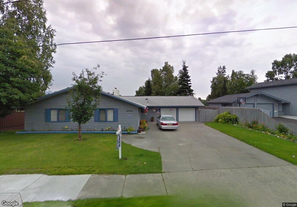
2000 Stanford Dr Anchorage, AK 99508
Rogers Park NeighborhoodEstimated Value: $205,000 - $970,790
4
Beds
3
Baths
3,952
Sq Ft
$179/Sq Ft
Est. Value
About This Home
This home is located at 2000 Stanford Dr, Anchorage, AK 99508 and is currently estimated at $705,597, approximately $178 per square foot. 2000 Stanford Dr is a home located in Anchorage Municipality with nearby schools including Lake Otis Elementary School, Wendler Middle School, and Bettye Davis East Anchorage High School.
Ownership History
Date
Name
Owned For
Owner Type
Purchase Details
Closed on
Jan 27, 2010
Sold by
Scott James R and Scott Carol
Bought by
Church Robert D and Church Jana M
Current Estimated Value
Home Financials for this Owner
Home Financials are based on the most recent Mortgage that was taken out on this home.
Original Mortgage
$410,000
Outstanding Balance
$269,717
Interest Rate
4.91%
Mortgage Type
New Conventional
Estimated Equity
$435,880
Create a Home Valuation Report for This Property
The Home Valuation Report is an in-depth analysis detailing your home's value as well as a comparison with similar homes in the area
Home Values in the Area
Average Home Value in this Area
Purchase History
| Date | Buyer | Sale Price | Title Company |
|---|---|---|---|
| Church Robert D | -- | Utg |
Source: Public Records
Mortgage History
| Date | Status | Borrower | Loan Amount |
|---|---|---|---|
| Open | Church Robert D | $410,000 |
Source: Public Records
Tax History Compared to Growth
Tax History
| Year | Tax Paid | Tax Assessment Tax Assessment Total Assessment is a certain percentage of the fair market value that is determined by local assessors to be the total taxable value of land and additions on the property. | Land | Improvement |
|---|---|---|---|---|
| 2025 | $14,246 | $1,062,300 | $320,400 | $741,900 |
| 2024 | $14,246 | $957,400 | $277,500 | $679,900 |
| 2023 | $14,774 | $867,500 | $277,500 | $590,000 |
| 2022 | $13,459 | $849,200 | $277,500 | $571,700 |
| 2021 | $14,268 | $791,800 | $277,500 | $514,300 |
| 2020 | $11,989 | $755,500 | $277,500 | $478,000 |
| 2019 | $12,043 | $786,100 | $308,300 | $477,800 |
| 2018 | $12,231 | $795,800 | $308,300 | $487,500 |
| 2017 | $10,646 | $699,800 | $308,300 | $391,500 |
| 2016 | $8,697 | $652,900 | $273,600 | $379,300 |
| 2015 | $8,697 | $632,700 | $273,600 | $359,100 |
| 2014 | $8,697 | $597,400 | $262,500 | $334,900 |
Source: Public Records
Map
Nearby Homes
- 1634 Stanford Dr
- 3411 Princeton Way
- 1826 E 27th Ave
- 3327 Wentworth St
- 2028 Shepherdia Dr
- 2124 Sorbus Way
- 3701 Young St
- 2624 Darby Cir
- 3421 Cottonwood St
- 3316 Vassar Dr
- 2553 Lovejoy Dr
- 1256 Redwood Ct
- 2456 Cottonwood St
- 2068 Cliffside Dr Unit 11
- 3818 Helvetia Dr
- 4246 Laurel St
- 1001 E Fireweed Ln
- 1819 E Tudor Rd Unit B102
- 1833 Parkside Dr
- 1803 Parkside Dr
- 1954 Stanford Dr
- 2016 Stanford Dr
- 1950 Stanford Dr
- 2028 Stanford Dr
- 2001 Stanford Dr
- 1951 Stanford Dr
- 3014 Columbia St
- 2040 Stanford Dr
- 1926 Stanford Dr
- 1939 Stanford Dr
- 2031 Stanford Dr
- 3001 Columbia St
- 2056 Stanford Dr
- 3000 Columbia St
- 1927 Stanford Dr
- 1912 Stanford Dr
- 3000 Yale Dr
- 2971 Drake Dr
- 2072 Stanford Dr
- 2929 Columbia St