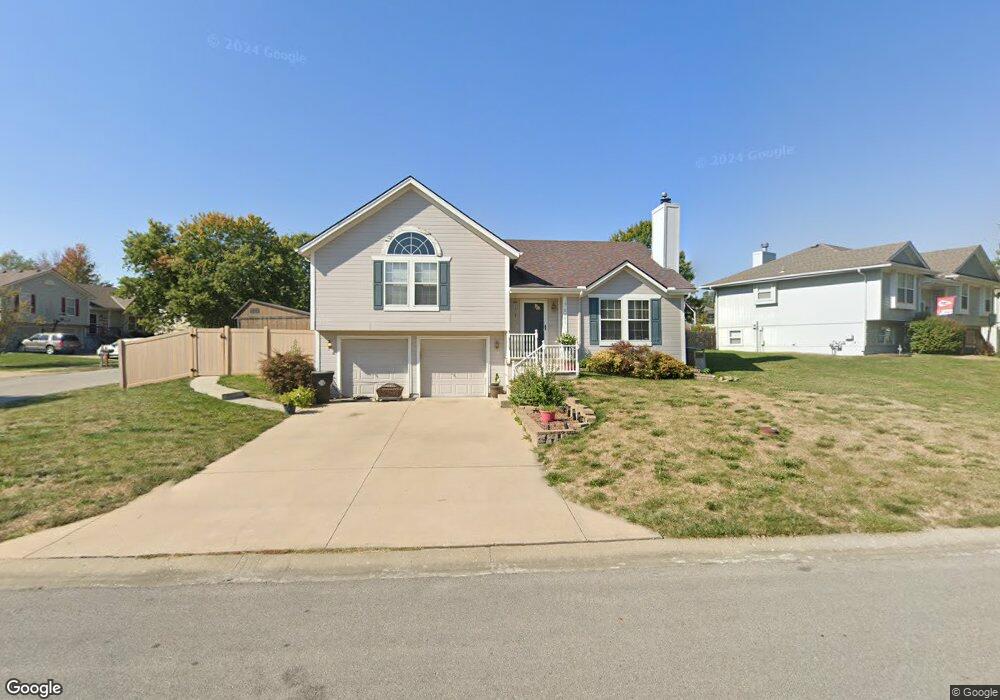
2001 Cypress Way Pleasant Hill, MO 64080
Estimated Value: $313,000 - $346,000
3
Beds
2
Baths
1,174
Sq Ft
$278/Sq Ft
Est. Value
About This Home
This home is located at 2001 Cypress Way, Pleasant Hill, MO 64080 and is currently estimated at $326,121, approximately $277 per square foot. 2001 Cypress Way is a home located in Cass County with nearby schools including Pleasant Hill Primary School, Pleasant Hill Elementary School, and Pleasant Hill Intermediate School.
Ownership History
Date
Name
Owned For
Owner Type
Purchase Details
Closed on
Mar 12, 2013
Sold by
Burbee David G and Burbee Lori B
Bought by
Burbee David G and Burbee Lori B
Current Estimated Value
Purchase Details
Closed on
Jun 11, 2007
Sold by
Ferdig David W
Bought by
Ferdig Lori B
Create a Home Valuation Report for This Property
The Home Valuation Report is an in-depth analysis detailing your home's value as well as a comparison with similar homes in the area
Home Values in the Area
Average Home Value in this Area
Purchase History
| Date | Buyer | Sale Price | Title Company |
|---|---|---|---|
| Burbee David G | -- | None Available | |
| Ferdig Lori B | -- | -- |
Source: Public Records
Tax History Compared to Growth
Tax History
| Year | Tax Paid | Tax Assessment Tax Assessment Total Assessment is a certain percentage of the fair market value that is determined by local assessors to be the total taxable value of land and additions on the property. | Land | Improvement |
|---|---|---|---|---|
| 2024 | $2,952 | $40,940 | $4,660 | $36,280 |
| 2023 | $2,931 | $40,940 | $4,660 | $36,280 |
| 2022 | $2,610 | $35,770 | $4,660 | $31,110 |
| 2021 | $2,538 | $35,770 | $4,660 | $31,110 |
| 2020 | $1,980 | $28,570 | $4,660 | $23,910 |
| 2019 | $1,953 | $28,570 | $4,660 | $23,910 |
| 2018 | $1,728 | $24,940 | $3,870 | $21,070 |
| 2017 | $1,647 | $24,940 | $3,870 | $21,070 |
| 2016 | $1,647 | $23,680 | $3,870 | $19,810 |
| 2015 | $1,668 | $23,680 | $3,870 | $19,810 |
| 2014 | $1,675 | $23,680 | $3,870 | $19,810 |
| 2013 | -- | $23,680 | $3,870 | $19,810 |
Source: Public Records
Map
Nearby Homes
- 1309 Pinoak Ct
- 1202 Ashford St
- 1202 Morgan Dr
- 2004 Owen Dr
- 1918 Owen Dr
- 1908 Owen Dr
- 1923 Fairground Dr
- 1405 E State Route Vv
- 1307 Deena St
- 1507 Trail Ridge Dr
- 25.8+/- Acres E 163rd St
- 0 E 163rd St Unit HMS2499275
- 29 Acres E State Route Vv
- 704 Terry Dr
- 631 Terry Dr
- 1807 Mystery Hill Dr
- 1004 Wright St
- 16025 Knorpp Rd
- 207 Breezeway Ln
- 1310 Sycamore St
- 2003 Cypress Way
- 1302 Pinoak Ct
- 2005 Cypress Way
- 1301 Pinoak Ct
- 1303 Pinoak Ct
- 1304 Pinoak Ct
- 1305 Pinoak Ct
- 2000 Cypress Way
- 2007 Cypress Way
- 1916 Cypress Way
- 2002 Cypress Way
- 1914 Cypress Way
- 2004 Cypress Way
- 2009 Cypress Way
- 1302 White Oak Place
- 2006 Cypress Way
- 1912 Cypress Way
- 1309 Pin Oak Ct
- 1307 Pinoak Ct
- 1306 Pinoak Ct