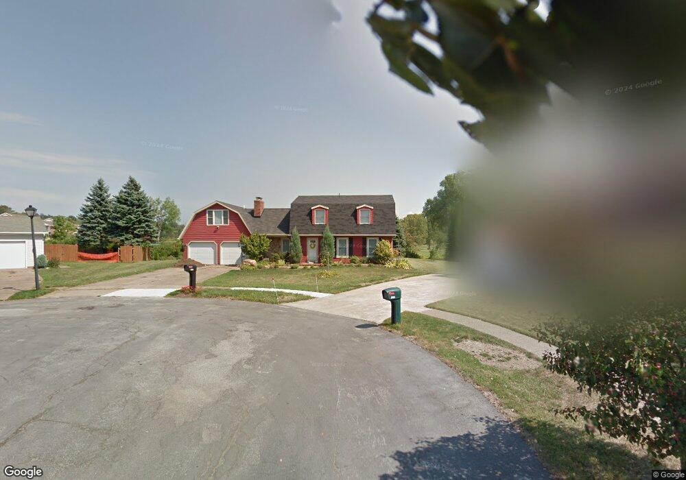
2001 Devon Ln Erie, PA 16509
Millcreek NeighborhoodEstimated Value: $226,000 - $385,131
4
Beds
3
Baths
2,591
Sq Ft
$127/Sq Ft
Est. Value
About This Home
This home is located at 2001 Devon Ln, Erie, PA 16509 and is currently estimated at $327,783, approximately $126 per square foot. 2001 Devon Ln is a home located in Erie County with nearby schools including McDowell High School, Chestnut Hill Elementary School, and James S. Wilson Middle School.
Ownership History
Date
Name
Owned For
Owner Type
Purchase Details
Closed on
Feb 26, 2009
Sold by
Mclaughlin Tod A and Mclaughlin Elizabeth A
Bought by
Alton Robert J and Alton Amy J
Current Estimated Value
Home Financials for this Owner
Home Financials are based on the most recent Mortgage that was taken out on this home.
Original Mortgage
$143,200
Outstanding Balance
$90,426
Interest Rate
5%
Mortgage Type
Purchase Money Mortgage
Estimated Equity
$237,357
Purchase Details
Closed on
Sep 29, 2003
Sold by
Estate Of Anthony E Orsini and Orsini Laura L
Bought by
Mclaughlin Tod A and Mclaughlin Elizabeth A
Home Financials for this Owner
Home Financials are based on the most recent Mortgage that was taken out on this home.
Original Mortgage
$147,900
Interest Rate
6.35%
Mortgage Type
VA
Purchase Details
Closed on
Apr 10, 1998
Sold by
Debello James C and Debello Diane M
Bought by
Orsini Anthony E
Create a Home Valuation Report for This Property
The Home Valuation Report is an in-depth analysis detailing your home's value as well as a comparison with similar homes in the area
Home Values in the Area
Average Home Value in this Area
Purchase History
| Date | Buyer | Sale Price | Title Company |
|---|---|---|---|
| Alton Robert J | $179,000 | None Available | |
| Mclaughlin Tod A | $145,000 | -- | |
| Orsini Anthony E | $147,500 | -- |
Source: Public Records
Mortgage History
| Date | Status | Borrower | Loan Amount |
|---|---|---|---|
| Open | Alton Robert J | $143,200 | |
| Previous Owner | Mclaughlin Tod A | $147,900 |
Source: Public Records
Tax History Compared to Growth
Tax History
| Year | Tax Paid | Tax Assessment Tax Assessment Total Assessment is a certain percentage of the fair market value that is determined by local assessors to be the total taxable value of land and additions on the property. | Land | Improvement |
|---|---|---|---|---|
| 2025 | $5,631 | $204,900 | $41,800 | $163,100 |
| 2024 | $5,484 | $204,900 | $41,800 | $163,100 |
| 2023 | $5,177 | $204,900 | $41,800 | $163,100 |
| 2022 | $4,974 | $204,900 | $41,800 | $163,100 |
| 2021 | $4,265 | $177,600 | $41,800 | $135,800 |
| 2020 | $4,220 | $177,600 | $41,800 | $135,800 |
| 2019 | $4,150 | $177,600 | $41,800 | $135,800 |
| 2018 | $4,048 | $177,600 | $41,800 | $135,800 |
| 2017 | $4,039 | $177,600 | $41,800 | $135,800 |
| 2016 | $4,825 | $177,600 | $41,800 | $135,800 |
| 2015 | $4,781 | $177,600 | $41,800 | $135,800 |
| 2014 | $1,507 | $177,600 | $41,800 | $135,800 |
Source: Public Records
Map
Nearby Homes
- 4636 Wynburne Ave
- 1842 Zimmerly Rd
- 1828 Zimmerly Rd
- 4905 Conway St
- 4830 Greenwood St
- 1718 W 56th St
- 4333 Caroline Dr
- 4002 Harvard Rd
- 1918 W 38th St
- 5005 Zuck Rd Unit 7
- 5005 Zuck Rd Unit 123
- 5005 Zuck Rd Unit 61
- 2381 Zimmerly Rd
- 1821 W 37th St
- 1530 W 43rd St
- 0 Village Common Dr Unit 174040
- 0 Village Common Dr Unit 174038
- 0 Peach St
- 3621 Ellsworth Ave
- 1425 Nicholson St
- 2005 Devon Ln
- 2002 Devon Ln
- 2008 Enfield Ln
- 2015 Devon Ln
- 2006 Devon Ln
- 2012 Enfield Ln
- 2014 Devon Ln
- 2023 Devon Ln
- 2022 Enfield Ln
- 2005 Charleston Ave
- 2004 Enfield Ln
- 2001 Charleston Ave
- 2020 Devon Ln
- 2030 Enfield Ln
- 2029 Devon Ln
- 2015 Charleston Ave
- 2034 Enfield Ln
- 2023 Charleston Ave
- 2003 Enfield Ln
- 2028 Devon Ln