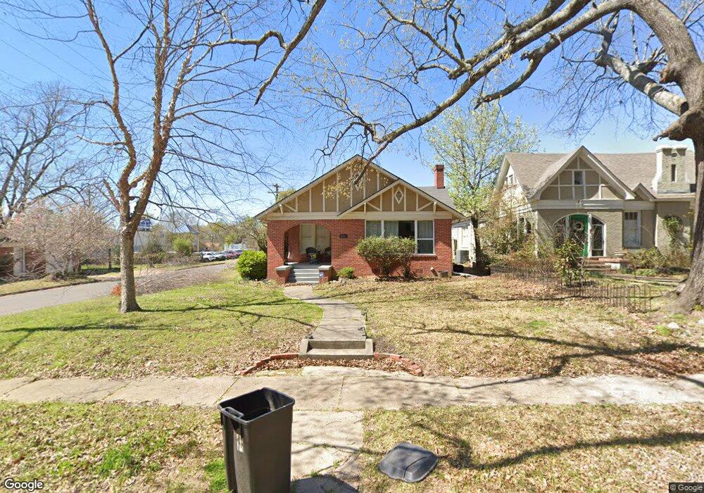
2001 Laurel St Texarkana, AR 71854
Estimated Value: $172,434 - $196,000
3
Beds
2
Baths
1,850
Sq Ft
$98/Sq Ft
Est. Value
About This Home
This home is located at 2001 Laurel St, Texarkana, AR 71854 and is currently estimated at $180,859, approximately $97 per square foot. 2001 Laurel St is a home located in Miller County with nearby schools including Arkansas High School and Premier High School - Texarkana.
Ownership History
Date
Name
Owned For
Owner Type
Purchase Details
Closed on
Aug 10, 2020
Sold by
Mcalister Michael B and Becnel Christopher
Bought by
Mcgary Steven and Mcgary Leslie
Current Estimated Value
Home Financials for this Owner
Home Financials are based on the most recent Mortgage that was taken out on this home.
Original Mortgage
$137,655
Outstanding Balance
$121,324
Interest Rate
2.9%
Mortgage Type
New Conventional
Estimated Equity
$59,535
Purchase Details
Closed on
May 2, 2005
Sold by
Asimos Helen
Bought by
Kennedy John Shane and Kennedy Robyn
Home Financials for this Owner
Home Financials are based on the most recent Mortgage that was taken out on this home.
Original Mortgage
$100,000
Interest Rate
5.92%
Mortgage Type
Construction
Purchase Details
Closed on
Nov 1, 1988
Bought by
Asimos Helen H
Purchase Details
Closed on
Jun 9, 1988
Bought by
Bray Ida Samples
Create a Home Valuation Report for This Property
The Home Valuation Report is an in-depth analysis detailing your home's value as well as a comparison with similar homes in the area
Purchase History
| Date | Buyer | Sale Price | Title Company |
|---|---|---|---|
| Mcgary Steven | $137,655 | None Available | |
| Kennedy John Shane | $56,000 | Stewart Title | |
| Asimos Helen H | $29,300 | -- | |
| Bray Ida Samples | -- | -- |
Source: Public Records
Mortgage History
| Date | Status | Borrower | Loan Amount |
|---|---|---|---|
| Open | Mcgary Steven | $137,655 | |
| Previous Owner | Kennedy John Shane | $100,000 |
Source: Public Records
Tax History
| Year | Tax Paid | Tax Assessment Tax Assessment Total Assessment is a certain percentage of the fair market value that is determined by local assessors to be the total taxable value of land and additions on the property. | Land | Improvement |
|---|---|---|---|---|
| 2025 | $846 | $31,360 | $1,880 | $29,480 |
| 2024 | $877 | $23,990 | $1,880 | $22,110 |
| 2023 | $892 | $23,990 | $1,880 | $22,110 |
| 2022 | $942 | $23,990 | $1,880 | $22,110 |
| 2021 | $942 | $23,990 | $1,880 | $22,110 |
| 2020 | $942 | $23,990 | $1,880 | $22,110 |
| 2019 | $912 | $22,990 | $1,880 | $21,110 |
| 2018 | $912 | $22,990 | $1,880 | $21,110 |
| 2017 | $912 | $22,990 | $1,880 | $21,110 |
| 2016 | $912 | $22,990 | $1,880 | $21,110 |
| 2015 | $909 | $22,940 | $1,880 | $21,060 |
| 2014 | -- | $14,834 | $1,725 | $13,109 |
Source: Public Records
Map
Nearby Homes
- 2003 Laurel St
- 2015 Laurel St
- 2002 Laurel St
- 1919 Laurel St
- 1915 Laurel St
- 2017 Laurel St
- 2012 Laurel St
- 1924 Laurel St
- 2014 Laurel St
- 1913 Laurel St
- 2006 N State Line Ave
- 2021 Laurel St
- 2020 Laurel St
- 1911 Laurel St
- 000 U S 71
- 0 U S 71
- 1916 Laurel St
- 2003 Glendale Ave
- 206 E 20th St
- 2005 Glendale Ave
Your Personal Tour Guide
Ask me questions while you tour the home.