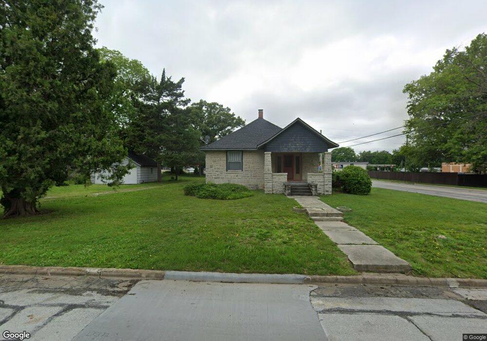
2001 S Maple St Carthage, MO 64836
Estimated Value: $177,639 - $203,000
Studio
1
Bath
1,440
Sq Ft
$131/Sq Ft
Est. Value
About This Home
This home is located at 2001 S Maple St, Carthage, MO 64836 and is currently estimated at $189,213, approximately $131 per square foot. 2001 S Maple St is a home located in Jasper County with nearby schools including Carthage High School, St. Ann's Catholic School, and Victory Academy.
Ownership History
Date
Name
Owned For
Owner Type
Purchase Details
Closed on
Oct 25, 2012
Sold by
Reber Greg S and Reber Charlotte Ann
Bought by
Mathis Ii Raymond S
Current Estimated Value
Purchase Details
Closed on
Mar 22, 2011
Sold by
Wilson E Wayne and Wilson Michelle C
Bought by
Reber Greg S and Reber Charlotte Ann
Home Financials for this Owner
Home Financials are based on the most recent Mortgage that was taken out on this home.
Original Mortgage
$40,000
Interest Rate
5.06%
Mortgage Type
Future Advance Clause Open End Mortgage
Purchase Details
Closed on
Feb 8, 2011
Sold by
Perkins Letitia Boyd
Bought by
Wilson E Wayne and Wilson Michelle C
Home Financials for this Owner
Home Financials are based on the most recent Mortgage that was taken out on this home.
Original Mortgage
$40,000
Interest Rate
5.06%
Mortgage Type
Future Advance Clause Open End Mortgage
Create a Home Valuation Report for This Property
The Home Valuation Report is an in-depth analysis detailing your home's value as well as a comparison with similar homes in the area
Home Values in the Area
Average Home Value in this Area
Purchase History
| Date | Buyer | Sale Price | Title Company |
|---|---|---|---|
| Mathis Ii Raymond S | -- | Fidility Abstract & Title Co | |
| Reber Greg S | -- | None Available | |
| Wilson E Wayne | -- | None Available |
Source: Public Records
Mortgage History
| Date | Status | Borrower | Loan Amount |
|---|---|---|---|
| Previous Owner | Reber Greg S | $40,000 |
Source: Public Records
Tax History
| Year | Tax Paid | Tax Assessment Tax Assessment Total Assessment is a certain percentage of the fair market value that is determined by local assessors to be the total taxable value of land and additions on the property. | Land | Improvement |
|---|---|---|---|---|
| 2021 | $627 | $12,660 | $3,270 | $9,390 |
| 2020 | $627 | $11,840 | $3,270 | $8,570 |
| 2019 | $628 | $11,840 | $3,270 | $8,570 |
| 2018 | $610 | $11,520 | $0 | $0 |
| 2017 | $611 | $11,520 | $0 | $0 |
| 2016 | $560 | $11,460 | $0 | $0 |
| 2015 | $560 | $11,460 | $0 | $0 |
| 2014 | $560 | $11,460 | $0 | $0 |
Source: Public Records
Map
Nearby Homes
- 510 W Fairview Ave
- 1830 S Maple St
- TBD Hazel Ave
- 509 W Highland Ave
- 2206 Benjamin Dr
- 1615 Forest St
- 303 W Centennial Ave
- 1513 S Main St
- 1910 Wynwood Dr
- 2203 Modern Ave
- XXXX Clinton
- 504 Cooper St
- 702 E Centennial Ave
- TBD Lexie Ln
- 1746 Robertson Ave
- 1710 Robertson Ave
- 1732 Robertson Ave
- 1702 Robertson Ave
- 1736 Robertson Ave
- 1720 Robertson Ave
- 2011 S Maple St
- 1945 S Maple St
- 2021 S Maple St
- 2002 S Maple St
- 2008 S Maple St
- 1946 S Garrison Ave
- 2014 S Maple St
- 1937 S Maple St
- 2018 S Garrison Ave
- 2031 S Maple St
- 2020 S Maple St
- 1932 S Maple St
- 1925 S Maple St
- 2026 S Maple St
- 2035 S Maple St
- 111 W Fairview Ave
- 2032 S Maple St
- 1924 S Maple St
- 1926 S Garrison Ave
- 1917 S Maple St
Your Personal Tour Guide
Ask me questions while you tour the home.