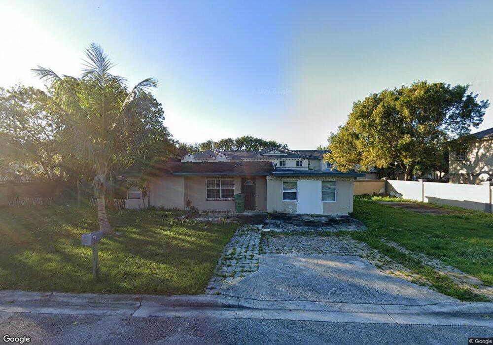
2001 W 12th St Riviera Beach, FL 33404
Estimated Value: $152,000 - $340,000
--
Bed
1
Bath
1,214
Sq Ft
$203/Sq Ft
Est. Value
About This Home
This home is located at 2001 W 12th St, Riviera Beach, FL 33404 and is currently estimated at $246,185, approximately $202 per square foot. 2001 W 12th St is a home located in Palm Beach County with nearby schools including Dr. Mary Mcleod Bethune Elementary School, William T. Dwyer High School, and John F. Kennedy Middle School.
Ownership History
Date
Name
Owned For
Owner Type
Purchase Details
Closed on
Jun 2, 2025
Sold by
Bethell Cecilia and Bethell Cecelia L
Bought by
Starr Empire Consulting Llcp Trust and Starr Empire Consulting Llc
Current Estimated Value
Purchase Details
Closed on
Nov 8, 2024
Sold by
Garvin Alphonso and Ivy Beverly
Bought by
Starr Empire Consulting Llc
Purchase Details
Closed on
Aug 15, 2024
Sold by
Dockery Estelle G
Bought by
Bethell Dwain David and Bethell Cecilia L
Create a Home Valuation Report for This Property
The Home Valuation Report is an in-depth analysis detailing your home's value as well as a comparison with similar homes in the area
Home Values in the Area
Average Home Value in this Area
Purchase History
| Date | Buyer | Sale Price | Title Company |
|---|---|---|---|
| Starr Empire Consulting Llcp Trust | -- | None Listed On Document | |
| Starr Empire Consulting Llcp Trust | -- | None Listed On Document | |
| Starr Empire Consulting Llc | -- | None Listed On Document | |
| Starr Empire Consulting Llc | -- | None Listed On Document | |
| Starr Empire Consulting Llc | -- | None Listed On Document | |
| Bethell Dwain David | -- | None Listed On Document |
Source: Public Records
Tax History Compared to Growth
Tax History
| Year | Tax Paid | Tax Assessment Tax Assessment Total Assessment is a certain percentage of the fair market value that is determined by local assessors to be the total taxable value of land and additions on the property. | Land | Improvement |
|---|---|---|---|---|
| 2024 | $2,385 | $78,553 | -- | -- |
| 2023 | $2,141 | $71,412 | $0 | $0 |
| 2022 | $1,825 | $64,920 | $0 | $0 |
| 2021 | $1,596 | $78,229 | $9,600 | $68,629 |
| 2020 | $1,478 | $71,743 | $7,800 | $63,943 |
| 2019 | $1,376 | $65,469 | $6,600 | $58,869 |
| 2018 | $1,201 | $54,552 | $6,085 | $48,467 |
| 2017 | $1,103 | $47,342 | $4,346 | $42,996 |
| 2016 | $1,010 | $36,645 | $0 | $0 |
| 2015 | $954 | $33,314 | $0 | $0 |
| 2014 | $924 | $30,285 | $0 | $0 |
Source: Public Records
Map
Nearby Homes
- 1982 Freeport Dr
- 1961 Freeport Dr Unit 4912
- 1962 Freeport Ln Unit 1962
- 2004 Freeport Ln
- 2010 Freeport Dr Unit 4104
- 975 Tortuga Ln
- 967 Tortuga Ln
- 1967 Marsh Harbor Dr
- 1203 Abaco Ln
- 1945 Marsh Harbor Dr Unit 302
- 1997 Marsh Harbor Dr Unit 411
- 991 Abaco Ln
- 1229 Abaco Ln
- 1112 Lucaya Dr
- 2007 Nassau Dr
- 1224 Lucaya Dr
- 1231 Lucaya Dr
- 2014 Marsh Harbor Dr
- 2033 Nassau Dr
- 2035 Nassau Dr
- 2000 Freeport Dr Unit 4107
- 2000 Freeport Ln Unit 2000
- 2000 Freeport Ln Unit 4107
- 2000 Freeport Ln
- 2002 Freeport Dr Unit 4108
- 2004 Freeport Dr Unit 2004
- 2004 Freeport Dr
- 1991 Freeport Dr
- 1993 Freeport Dr
- 1989 Freeport Dr
- 1995 Freeport Dr
- 1995 Freeport Dr Unit 1995
- 1993 Freeport Ln
- 1997 Freeport Dr
- 2006 Freeport Ln
- 2006 Freeport Dr Unit 4105
- 2008 Freeport Dr
- 1995 Freeport Ln
- 2004 Freeport Ln Unit 2004
- 2002 Freeport Ln Unit 4108