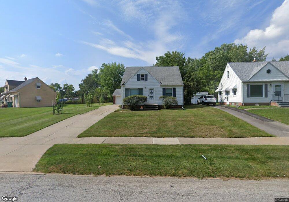
20011 Maple Heights Blvd Maple Heights, OH 44137
Estimated Value: $119,000 - $124,000
3
Beds
1
Bath
1,092
Sq Ft
$111/Sq Ft
Est. Value
About This Home
This home is located at 20011 Maple Heights Blvd, Maple Heights, OH 44137 and is currently estimated at $121,470, approximately $111 per square foot. 20011 Maple Heights Blvd is a home located in Cuyahoga County with nearby schools including Abraham Lincoln Elementary School, Rockside/ J.F. Kennedy School, and Italy High School.
Ownership History
Date
Name
Owned For
Owner Type
Purchase Details
Closed on
Dec 30, 1991
Sold by
Tenbrook Kevin M
Bought by
Tenbrook Deborah L
Current Estimated Value
Purchase Details
Closed on
Sep 30, 1985
Sold by
Pamula Flora A
Bought by
Tenbrook Kevin M
Purchase Details
Closed on
Feb 24, 1983
Sold by
Pamula Joseph T and Pamula Flora A
Bought by
Pamula Flora A
Purchase Details
Closed on
Jan 1, 1975
Bought by
Pamula Joseph T and Pamula Flora A
Create a Home Valuation Report for This Property
The Home Valuation Report is an in-depth analysis detailing your home's value as well as a comparison with similar homes in the area
Home Values in the Area
Average Home Value in this Area
Purchase History
| Date | Buyer | Sale Price | Title Company |
|---|---|---|---|
| Tenbrook Deborah L | -- | -- | |
| Tenbrook Kevin M | $49,500 | -- | |
| Pamula Flora A | -- | -- | |
| Pamula Joseph T | -- | -- |
Source: Public Records
Tax History Compared to Growth
Tax History
| Year | Tax Paid | Tax Assessment Tax Assessment Total Assessment is a certain percentage of the fair market value that is determined by local assessors to be the total taxable value of land and additions on the property. | Land | Improvement |
|---|---|---|---|---|
| 2024 | $3,264 | $35,805 | $10,045 | $25,760 |
| 2023 | $2,135 | $19,220 | $5,740 | $13,480 |
| 2022 | $2,128 | $19,220 | $5,740 | $13,480 |
| 2021 | $2,262 | $19,220 | $5,740 | $13,480 |
| 2020 | $1,945 | $14,560 | $4,340 | $10,220 |
| 2019 | $1,931 | $41,600 | $12,400 | $29,200 |
| 2018 | $1,823 | $14,560 | $4,340 | $10,220 |
| 2017 | $1,869 | $13,760 | $4,060 | $9,700 |
| 2016 | $1,806 | $13,760 | $4,060 | $9,700 |
| 2015 | $1,798 | $13,760 | $4,060 | $9,700 |
| 2014 | $1,798 | $15,130 | $4,450 | $10,680 |
Source: Public Records
Map
Nearby Homes
- 20120 Mccracken Rd
- 20715 Watson Rd
- 20814 Watson Rd
- 20907 Watson Rd
- 19807 Gardenview Dr
- 19309 Nitra Ave
- 5165 Camden Rd
- 21102 Raymond St
- 19520 Maple Heights Blvd
- 19806 Mountville Dr
- 20107 Libby Rd
- 20510 Mountville Dr
- 20701 Kenyon Dr
- 21207 Franklin Rd
- 20814 Kenyon Dr
- 19812 Stockton Ave
- 19289 Stafford Ave
- 5265 Bellview St
- 19221 Stafford Ave
- 21416 Gardenview Dr
- 20015 Maple Heights Blvd
- 19921 Fairway Ave
- 19917 Fairway Ave
- 20101 Maple Heights Blvd
- 19913 Fairway Ave
- 19909 Fairway Ave
- 20109 Maple Heights Blvd
- 19905 Fairway Ave
- 20060 Mccracken Rd
- 20040 Mccracken Rd
- 19923 Maple Heights Blvd
- 20080 Mccracken Rd
- 20020 Mccracken Rd
- 20100 Mccracken Rd
- 20113 Maple Heights Blvd
- 20000 Mccracken Rd
- 19901 Fairway Ave
- 19919 Maple Heights Blvd
- 20140 Mccracken Rd
- 19980 Mccracken Rd