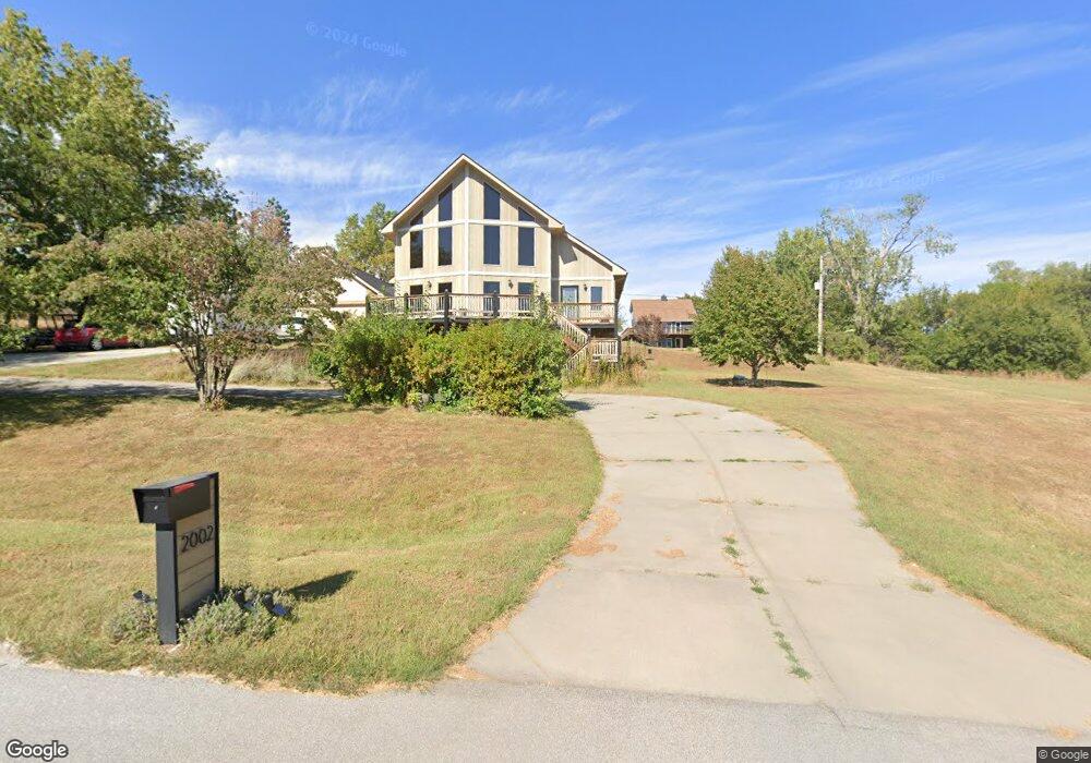
2002 Dunbar Dr Plattsmouth, NE 68048
Estimated Value: $473,000 - $571,000
5
Beds
3
Baths
3,284
Sq Ft
$157/Sq Ft
Est. Value
About This Home
This home is located at 2002 Dunbar Dr, Plattsmouth, NE 68048 and is currently estimated at $514,157, approximately $156 per square foot. 2002 Dunbar Dr is a home located in Cass County with nearby schools including Conestoga Elementary School and Conestoga Junior/Senior High School.
Ownership History
Date
Name
Owned For
Owner Type
Purchase Details
Closed on
Oct 19, 2009
Sold by
Martier Richard W and Martier Kimberly
Bought by
Maxwell Jayson W and Maxwell Monica G
Current Estimated Value
Home Financials for this Owner
Home Financials are based on the most recent Mortgage that was taken out on this home.
Original Mortgage
$272,700
Interest Rate
5.03%
Create a Home Valuation Report for This Property
The Home Valuation Report is an in-depth analysis detailing your home's value as well as a comparison with similar homes in the area
Home Values in the Area
Average Home Value in this Area
Purchase History
| Date | Buyer | Sale Price | Title Company |
|---|---|---|---|
| Maxwell Jayson W | $267,000 | -- |
Source: Public Records
Mortgage History
| Date | Status | Borrower | Loan Amount |
|---|---|---|---|
| Closed | Maxwell Jayson W | $272,700 |
Source: Public Records
Tax History Compared to Growth
Tax History
| Year | Tax Paid | Tax Assessment Tax Assessment Total Assessment is a certain percentage of the fair market value that is determined by local assessors to be the total taxable value of land and additions on the property. | Land | Improvement |
|---|---|---|---|---|
| 2024 | $5,113 | $402,190 | $39,075 | $363,115 |
| 2023 | $5,114 | $382,323 | $36,598 | $345,725 |
| 2022 | $5,344 | $372,312 | $38,428 | $333,884 |
| 2021 | $5,003 | $336,415 | $14,735 | $321,680 |
| 2020 | $4,724 | $308,123 | $13,704 | $294,419 |
| 2019 | $4,384 | $269,779 | $3,749 | $266,030 |
| 2018 | $4,312 | $269,779 | $3,749 | $266,030 |
| 2017 | $4,116 | $254,262 | $3,749 | $250,513 |
| 2016 | $3,939 | $254,262 | $3,749 | $250,513 |
| 2015 | $3,923 | $254,262 | $3,749 | $250,513 |
| 2014 | $4,418 | $254,262 | $3,749 | $250,513 |
Source: Public Records
Map
Nearby Homes
- 1709 Dunbar Dr
- 9518 Sterling Cir
- 1715 Rock Bluff Rd
- 9315 Clubhouse Cir
- 113 Rock Bluff Rd Unit 1
- 113 Rock Bluff Rd
- 1524 Trumball Terrace
- 1443 Koby Cir
- 9811 Rock Creek Rd
- 8862 Greenwood Rd
- 1402 Elm Creek Rd
- 8883 Verdon Cir
- 8887 Verdon Cir
- 9109 Murray Dr
- 9012 Murray Dr
- 9019 Bellvue Dr
- 1928 Beaver Lake Blvd
- 2206 Beaver Lake Blvd
- 1812 Beaver Lake Blvd
- 914 Beaver Lake Blvd
- 1920 Dunbar Dr
- 2005 Rock Bluff Rd
- 1918 Dunbar Dr
- 2011 Rock Bluff Rd
- 2010 Dunbar Dr
- 1624 Taz Ln
- 2015 Rock Bluff Rd
- 1912 Dunbar Dr
- 2110 Dunbar Dr
- 2008 Dunbar Dr
- 1905 Dunbar Dr
- 2013 Dunbar Dr
- 2014 Dunbar Dr
- 1917 Dunbar Dr
- 1913 Rock Bluff Rd
- 1913 Dunbar Dr
- 2016 Dunbar Dr
- 2101 Rock Bluff Rd
- 1906 Dunbar Dr
- 1909 Rock Bluff Rd