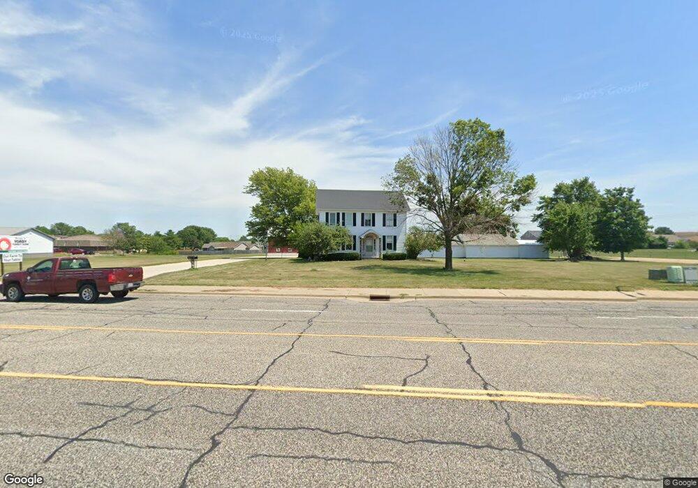
2002 S Main St Morton, IL 61550
Estimated Value: $292,000 - $349,000
5
Beds
2
Baths
1,758
Sq Ft
$177/Sq Ft
Est. Value
About This Home
This home is located at 2002 S Main St, Morton, IL 61550 and is currently estimated at $311,955, approximately $177 per square foot. 2002 S Main St is a home located in Tazewell County with nearby schools including Morton High School, Bethel Lutheran School, and Blessed Sacrament School.
Ownership History
Date
Name
Owned For
Owner Type
Purchase Details
Closed on
May 22, 2023
Sold by
Yordy Brent L and Yordy Sally A
Bought by
Brent L Yordy Trust and Sally A Yordy Trust
Current Estimated Value
Purchase Details
Closed on
Dec 30, 2005
Sold by
Ennis Steven J and Ennis Connie L
Bought by
Yordy Brent and Yordy Sally
Purchase Details
Closed on
Oct 31, 2005
Sold by
Anthonys Originals On Main Llc
Bought by
Ennis Steven J and Ennis Connie L
Create a Home Valuation Report for This Property
The Home Valuation Report is an in-depth analysis detailing your home's value as well as a comparison with similar homes in the area
Home Values in the Area
Average Home Value in this Area
Purchase History
| Date | Buyer | Sale Price | Title Company |
|---|---|---|---|
| Brent L Yordy Trust | -- | None Listed On Document | |
| Yordy Brent | $125,000 | First American Title | |
| Ennis Steven J | -- | -- |
Source: Public Records
Tax History Compared to Growth
Tax History
| Year | Tax Paid | Tax Assessment Tax Assessment Total Assessment is a certain percentage of the fair market value that is determined by local assessors to be the total taxable value of land and additions on the property. | Land | Improvement |
|---|---|---|---|---|
| 2024 | $6,159 | $90,150 | $46,980 | $43,170 |
| 2023 | $6,159 | $83,990 | $43,770 | $40,220 |
| 2022 | $5,957 | $77,140 | $40,200 | $36,940 |
| 2021 | $5,730 | $74,170 | $38,650 | $35,520 |
| 2020 | $5,555 | $73,440 | $38,270 | $35,170 |
| 2019 | $5,540 | $73,440 | $38,270 | $35,170 |
| 2018 | $5,438 | $73,440 | $38,270 | $35,170 |
| 2017 | $5,298 | $72,710 | $37,890 | $34,820 |
| 2016 | $5,196 | $72,710 | $37,890 | $34,820 |
| 2015 | $3,094 | $0 | $0 | $0 |
| 2013 | $3,063 | $43,200 | $4,030 | $39,170 |
Source: Public Records
Map
Nearby Homes
- 2100 S 2nd Ave Unit 2100
- 2020 S 2nd Ave Unit 2020
- 50 Brooke Cir Unit 50
- 1220 S Main St
- 384 E Maywood St
- 749 S Columbus Ave
- 600 S Columbus Ave
- 210 E Crestwood St
- 315 E Birchwood St
- 504 S Glen Ave
- 1156 Brentwood Rd
- 324 S Kansas Ave
- 329 S Nelson Ave
- 507 E Adams St
- 407 E Jefferson St
- 120 N Indiana Ave
- 118 S Liberty Ave
- 115 S Liberty Ave
- 328 N 3rd Ave
- 1209 Whippoorwill Dr