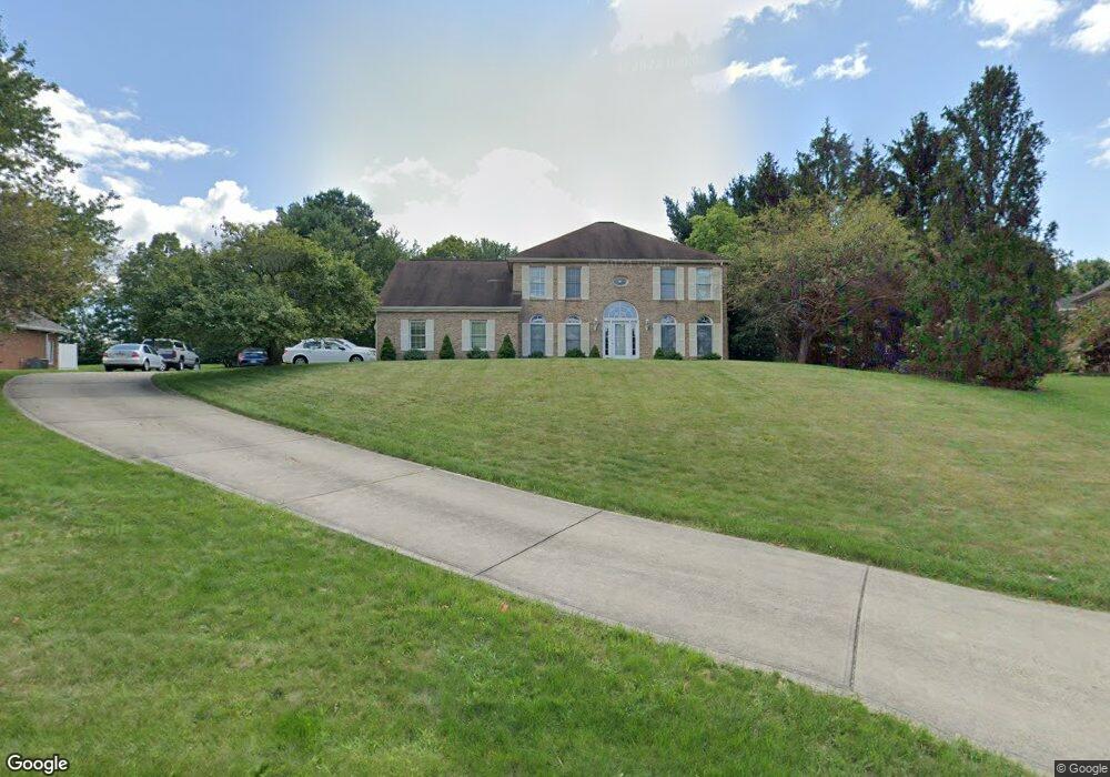
2003 High Pointe Ct Murrysville, PA 15668
Estimated Value: $202,220 - $604,000
--
Bed
--
Bath
--
Sq Ft
0.82
Acres
About This Home
This home is located at 2003 High Pointe Ct, Murrysville, PA 15668 and is currently estimated at $477,555. 2003 High Pointe Ct is a home located in Westmoreland County with nearby schools including Franklin Regional Senior High School, Mother of Sorrows School, and Greater Works Christian School.
Ownership History
Date
Name
Owned For
Owner Type
Purchase Details
Closed on
Aug 20, 2007
Sold by
Gattens Philip R and Gattens Darlene D
Bought by
Peterson Gerald L and Peterson Karen E
Current Estimated Value
Home Financials for this Owner
Home Financials are based on the most recent Mortgage that was taken out on this home.
Original Mortgage
$258,000
Outstanding Balance
$164,352
Interest Rate
6.78%
Mortgage Type
Purchase Money Mortgage
Estimated Equity
$313,203
Create a Home Valuation Report for This Property
The Home Valuation Report is an in-depth analysis detailing your home's value as well as a comparison with similar homes in the area
Home Values in the Area
Average Home Value in this Area
Purchase History
| Date | Buyer | Sale Price | Title Company |
|---|---|---|---|
| Peterson Gerald L | $335,000 | None Available |
Source: Public Records
Mortgage History
| Date | Status | Borrower | Loan Amount |
|---|---|---|---|
| Open | Peterson Gerald L | $258,000 |
Source: Public Records
Tax History Compared to Growth
Tax History
| Year | Tax Paid | Tax Assessment Tax Assessment Total Assessment is a certain percentage of the fair market value that is determined by local assessors to be the total taxable value of land and additions on the property. | Land | Improvement |
|---|---|---|---|---|
| 2025 | $8,729 | $57,280 | $11,760 | $45,520 |
| 2024 | $8,528 | $57,280 | $11,760 | $45,520 |
| 2023 | $8,013 | $57,280 | $11,760 | $45,520 |
| 2022 | $7,856 | $57,280 | $11,760 | $45,520 |
| 2021 | $7,684 | $57,280 | $11,760 | $45,520 |
| 2020 | $7,538 | $57,280 | $11,760 | $45,520 |
| 2019 | $7,383 | $57,280 | $11,760 | $45,520 |
| 2018 | $7,255 | $57,280 | $11,760 | $45,520 |
| 2017 | $7,104 | $57,280 | $11,760 | $45,520 |
| 2016 | $6,962 | $57,280 | $11,760 | $45,520 |
| 2015 | $6,962 | $57,280 | $11,760 | $45,520 |
| 2014 | $6,915 | $57,280 | $11,760 | $45,520 |
Source: Public Records
Map
Nearby Homes
- 3018 Settlers Ct
- 7 Sierra Dr
- 152 Black Hills Rd
- 8 Sierra Dr
- 3959 Sunflower Ct
- 120 Holiday Park Dr
- 5081 Harvest Dr
- 632 Tampico Ct
- 4204 Summervale Ct
- 5109 Hemlock Ln
- 5025 Impala Dr
- 425 Vista Ln
- 4902 Hialeah Dr
- 326 Glendale Dr
- 3017 Juniper Ct
- 360 Old Abers Creek Rd
- 4012 Cape Cod Dr
- 508 Presque Isle Dr
- 127 Mardi Gras Dr
- 5013 Hialeah Dr
- 2005 High Pointe Ct
- 1005 Summer Ridge Ct
- 1003 Summer Ridge Ct
- 1001 Summer Ridge Ct
- 2004 High Pointe Ct
- 2002 High Pointe Ct
- 2007 High Pointe Ct
- 2006 High Pointe Ct
- 2000 High Pointe Ct
- 4901 Logan Ferry Rd
- 2008 High Pointe Ct
- 1004 Summer Ridge Ct
- 1006 Summer Ridge Ct
- 2009 High Pointe Ct
- 1002 Summer Ridge Ct
- 1000 Summer Ridge Ct
- 1008 Summer Ridge Ct
- 3001 Wedgewood Ct
- 3005 Wedgewood Ct
- 3005 Wedgewood Ct