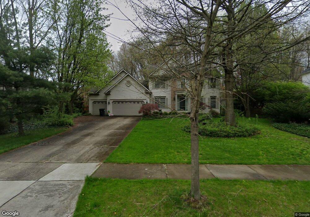
2004 Bent Creek Trail Cuyahoga Falls, OH 44223
High Hampton NeighborhoodEstimated Value: $486,000 - $635,000
4
Beds
4
Baths
3,132
Sq Ft
$180/Sq Ft
Est. Value
About This Home
This home is located at 2004 Bent Creek Trail, Cuyahoga Falls, OH 44223 and is currently estimated at $564,865, approximately $180 per square foot. 2004 Bent Creek Trail is a home located in Summit County with nearby schools including Woodridge Middle School, Woodridge High School, and Immaculate Heart Of Mary School.
Ownership History
Date
Name
Owned For
Owner Type
Purchase Details
Closed on
Jun 12, 1998
Sold by
Kurt Yoder Homes
Bought by
Maher Edward C
Current Estimated Value
Home Financials for this Owner
Home Financials are based on the most recent Mortgage that was taken out on this home.
Original Mortgage
$220,000
Interest Rate
7.32%
Mortgage Type
New Conventional
Purchase Details
Closed on
Jun 2, 1997
Sold by
High Hampton Dev
Bought by
Kurt Yoder Homes
Create a Home Valuation Report for This Property
The Home Valuation Report is an in-depth analysis detailing your home's value as well as a comparison with similar homes in the area
Home Values in the Area
Average Home Value in this Area
Purchase History
| Date | Buyer | Sale Price | Title Company |
|---|---|---|---|
| Maher Edward C | $275,000 | -- | |
| Kurt Yoder Homes | $63,600 | -- |
Source: Public Records
Mortgage History
| Date | Status | Borrower | Loan Amount |
|---|---|---|---|
| Previous Owner | Maher Edward C | $220,000 |
Source: Public Records
Tax History Compared to Growth
Tax History
| Year | Tax Paid | Tax Assessment Tax Assessment Total Assessment is a certain percentage of the fair market value that is determined by local assessors to be the total taxable value of land and additions on the property. | Land | Improvement |
|---|---|---|---|---|
| 2025 | $9,304 | $156,206 | $32,484 | $123,722 |
| 2024 | $9,304 | $156,206 | $32,484 | $123,722 |
| 2023 | $9,304 | $156,206 | $32,484 | $123,722 |
| 2022 | $8,252 | $122,997 | $25,578 | $97,419 |
| 2021 | $8,324 | $122,997 | $25,578 | $97,419 |
| 2020 | $8,224 | $123,000 | $25,580 | $97,420 |
| 2019 | $9,006 | $126,590 | $25,070 | $101,520 |
| 2018 | $9,166 | $126,590 | $25,070 | $101,520 |
| 2017 | $7,209 | $126,590 | $25,070 | $101,520 |
| 2016 | $7,177 | $104,120 | $25,070 | $79,050 |
| 2015 | $7,209 | $104,120 | $25,070 | $79,050 |
| 2014 | $6,790 | $104,120 | $25,070 | $79,050 |
| 2013 | $7,199 | $110,680 | $25,070 | $85,610 |
Source: Public Records
Map
Nearby Homes
- 1983 Fox Trace Trail
- 1977 Fox Trace Trail
- 2694 High Hampton Trail
- 2638 Deer Ridge Run
- 2064 Forest Edge Dr
- 163 Cedar Hill Cir
- 419 W Bath Rd
- 2180 Stone Creek Trail Unit 2180
- 1032 Foxglove Cir
- 2175 Pinebrook Trail
- 2133 Pinebrook Trail Unit 2133
- 595 Meredith Ln
- 2152 Pinebrook Trail Unit 2152
- 2885 Valley Rd
- 2125 Pinebrook Trail
- 594 Meredith Ln Unit J594
- 618 Meredith Ln
- 0 Graham Rd Unit 5100407
- 3168 Old Mill Dr
- 546 Meredith Ln Unit 546
- 2008 Bent Creek Trail
- 2000 Bent Creek Trail
- 2684 Timberline Trail
- 2680 Timberline Trail
- 2667 High Hampton Trail
- 2688 Timberline Trail
- 2007 Bent Creek Trail
- 2671 High Hampton Trail
- 2013 Bent Creek Trail
- 2676 Timberline Trail
- 2009 Bent Creek Trail
- 2690 Timberline Trail
- 1994 Fox Trace Trail
- 1992 Fox Trace Trail
- 1996 Fox Trace Trail
- 1998 Fox Trace Trail
- 1988 Fox Trace Trail
- 1986 Fox Trace Trail
- 2674 High Hampton Trail
- 2000 Fox Trace Trail